Shoshoni Peak via Pawnee Pass Hike
View Photos
Shoshoni Peak via Pawnee Pass Hike
Difficulty Rating:
The Shoshoni Peak via Pawnee Pass Hike is one for the books. Pass not one, but two shimmering alpine lakes before beginning your challenging trek up to the summit. This trail is not for the faint of heart. Navigate tightly wound switchbacks and find your way across the saddle before scrambling up to the peak. This trail is perfect for those seeking an adventure in the Indian Peaks Wilderness.
Getting there
The Shoshoni Peak via Pawnee Pass Hike begins at the Long Lake Trailhead at the end of Long Lake Road.

About
| Backcountry Campground | |
| When to do | June-October |
| Pets allowed | Yes - On Leash |
| Family friendly | No |
| Route Signage | Poor |
| Crowd Levels | Low |
| Route Type | Out and back |
Shoshoni Peak via Pawnee Pass Hike
Elevation Graph
Weather
Shoshoni Peak via Pawnee Pass Hike Description
You don’t have to ask us twice—sign us up for the Shoshoni Peak via Pawnee Pass Hike! Located in the Brainard Lake Recreational Area, hikers will have to purchase a parking pass. These can be reserved online or purchased on site. Starting at the Long Lake Trailhead, the initial section of the trail will be heavily trafficked before you branch off to Pawnee Pass. Scrambling is required to summit Shoshoni Peak, so make sure you are prepared and have adequate gear. Additionally, it will probably be very cold and windy as you summit the Continental Divide—bring layers! Not exhausting, but not easy, you should also bring plenty of water or a water filter on this excursion. We love this hike, and we are excited for you to try it!
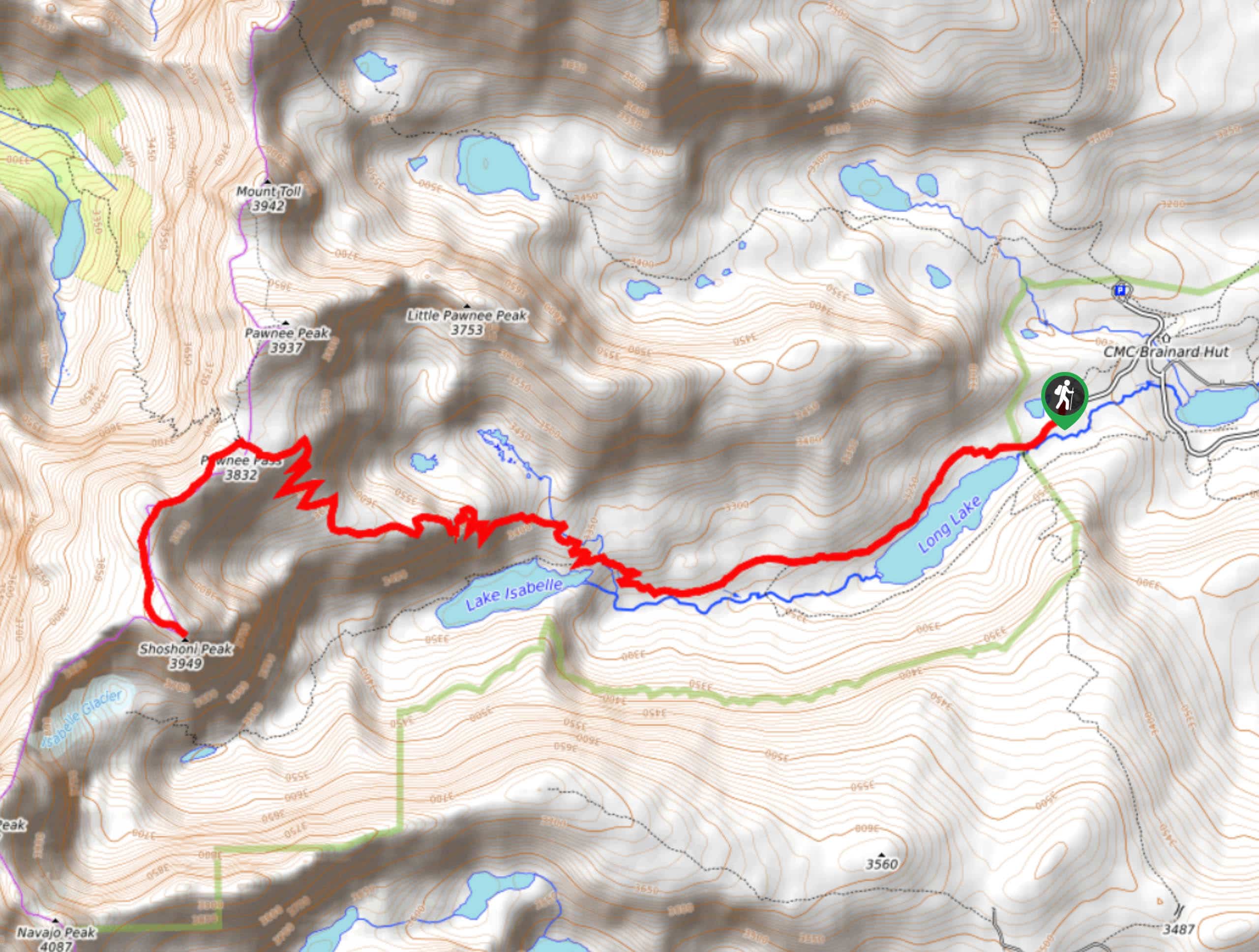
Starting your adventure from the Long Lake Trailhead and carpark, head southwest on Pawnee Pass Trail. This section of the trail is relaxed as it guides you through the lush aspen forests and along the shore of Long Lake. Continue along the Pawnee Pass Trail as you gain elevation heading towards Isabelle Lake. At the Isabelle Lake Junction, bear right to stay on the Pawnee Pass Trail. You will navigate a few switchbacks before ascending the timberline.
At this point, the trail becomes increasingly rocky and steep as you climb to the pass. Maneuver through more sets of tightly wound switchbacks before summiting the pass. It will be windy as you increase in altitude and climb across the ridge. From the pass, there is no defined path on the Shoshoni Summit Route. Head south over the ridge through the alpine tundra. Carefully scramble up the rocky scree to the summit. If it is a nice day, you will have amazing panoramic views of the Indian Peaks Wilderness from Shoshoni Peak.
Admire the scenery before beginning your descent. Exercise caution when desencfing the loose rock scree. Follow along the ridge back to Pawnee Pass and retrace your steps back to the parking lot.
Similar hikes to the Shoshoni Peak via Pawnee Pass Hike hike

Caribou Pass Hike
The Caribou Pass Trail scales the west side of the Continental Divide. This short but steep hike will get your…

Beaver Creek Trail
Beaver Creek Trail is a great wooded hike through the Colorado wilderness. With picturesque babbling brooks and past vast wildflower…
Beaver Reservoir to Monarch Lake Hike
Beaver Reservoir to Monarch Lake Hike is a one-way trail in the Indian Peaks Wilderness. We love this hike because…
Comments