Niwot Mountain via Left Hand Reservoir Road Hike
View Photos
Niwot Mountain via Left Hand Reservoir Road Hike
Difficulty Rating:
The Niwot Mountain via Left Hand Reservoir Road Hike is a great trail that can be hiked or snowshoed! This hike will guide you up the Niwot Mountain, through the alpine forest, and to the Left-Hand Reservoir. The trail is underdeveloped, so be prepared for some off-roading! Follow the GPS to ensure you are on the right route. Though a bit primitive, this trail is a perfect half day hike in the Indian Peaks.
Getting there
The Niwot Mountain via Left Hand Reservoir Road Hike Trailhead is off the Brainard Lake Road. Park in the Brainard Lake Winter Parking Lot.

About
| Backcountry Campground | Yes, permits required. |
| When to do | Year-round |
| Pets allowed | Yes - On Leash |
| Family friendly | Yes |
| Route Signage | Poor |
| Crowd Levels | Moderate |
| Route Type | Lollipop |
Niwot Mountain via Left Hand Reservoir Road Hike
Elevation Graph
Weather
Niwot Mountain via Left Hand Reservoir Road Hike Description
If you are looking for a moderate hike in the Indian Peaks Wilderness, the Niwot Mountain via Left Hand Reservoir Road Hike is perfect. Whether you are hiking or snowshoeing, just make sure you have a rough idea of the trail’s layout, or a GPS, as the west side of the trail is poorly marked. As you ascend the ridge toward Niwot Mountain, the trail is exposed, layer up and expect some wind!
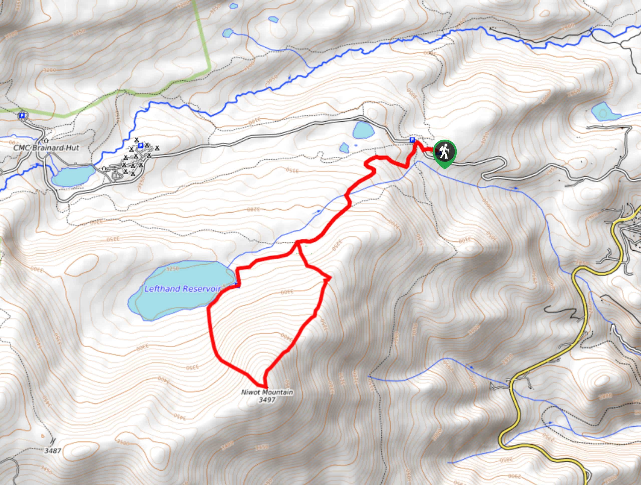
The Niwot Mountain via Left Hand Reservoir Road Hike begins from the Brainard Winter Parking Lot. From the parking lot, cross over the Brainard Lake Road and begin your hike along the Left Hand Reservoir Road. Continue along the road as it intersects with a creek before the junction. Here there are three paths. The trail can be completed in either direction, but we recommend going clockwise. Take the Niwot Mountain Trail, which is the path furthest to your left. Follow along this trail as you gain elevation and top the timberline. The terrain will be rockier as you hike the ridge and summit Niwot Mountain. From the top you will be rewarded with sights of Colorado’s snow dusted craggy peaks and alpine forests.
From the peak, head west down an unmarked path. This route will bring you down the mountain, through the lush forest, before delivering you to the shore of the Left Hand Reservoir. Follow the path as it follows the curves of the shore before guiding you back onto the Left Hand Reservoir Road. Continue along the road back to the carpark.
Similar hikes to the Niwot Mountain via Left Hand Reservoir Road Hike hike

Caribou Pass Hike
The Caribou Pass Trail scales the west side of the Continental Divide. This short but steep hike will get your…

Buchanan Pass Loop
The Buchanan Pass Loop is an awesome adventure trail. Adults and kids alike will enjoy this wildflower-speckled trail as it…

Beaver Creek Trail
Beaver Creek Trail is a great wooded hike through the Colorado wilderness. With picturesque babbling brooks and past vast wildflower…
Comments