
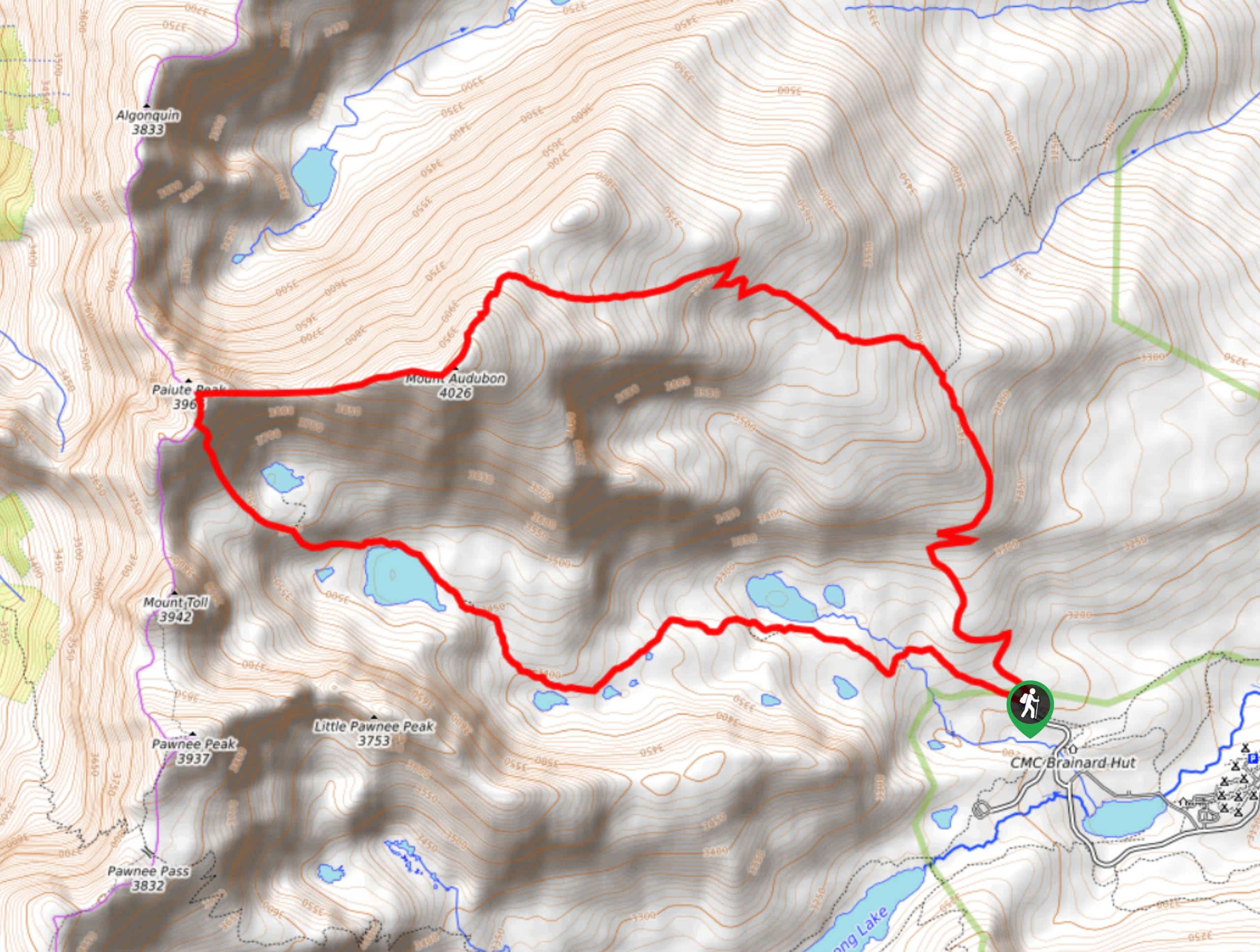
Mount Audubon and Paiute Peak Hike
View Photos
Mount Audubon and Paiute Peak Hike
Difficulty Rating:
Mount Audubon and Paiute Peak Hike is a demanding trail in the Colorado Peaks. The extreme elevation gain and technical terrain is packed into this short route. This hike is not for the faint of heart, but it is rewarding. You will pass three lakes and summit two peaks on this short circuit trail.
Getting there
This trail begins at the Mitchell Lake Trailhead in the Brainard Lake Recreational Area. Parking permits are required and can be reserved online or purchased at the kiosk on site.

About
| Backcountry Campground | |
| When to do | July-October |
| Pets allowed | Yes - On Leash |
| Family friendly | No |
| Route Signage | Average |
| Crowd Levels | Moderate |
| Route Type | Circuit |
Mount Audubon and Paiute Peak Hike
Elevation Graph
Weather
Mount Audubon and Paiute Peak Hike Description
Ready to conquer the Mount Audubon and Paiute Peak Trail? Make sure you pack plenty of water and snacks to refuel on this demanding hike. We would also recommend bringing microspikes and hiking poles, these will come in handy as you summit the craggy peaks! Good footwear and layers are also a good idea. Dogs are allowed on this trail if they remain on leash, but bear in mind the terrain is very rocky and steep. The Mount Audubon and Paiute Peak Hike is challenging, but with the correct gear and the right mindset, it is worthwhile. Note that the Brainard Lake Recreational Area closes in late-October until mid-June.
The Mount Audubon and Paiute Peak Loop can be completed in either direction, but we recommend going clockwise. Going clockwise means that hikers will ascend the steep, loose rocky talus to Paiute Peak, saving you from having to descend on your bum. From the Mitchell Trailhead hook onto the Mitchell Lake Trail. Continue along this trail as you intersect with a stream and pass Mitchell Lake. The path will curve southwest as you ascend the timberline. Now exposed, the terrain will become increasingly rocky. Follow along the path as it reaches Blue Lake and Little Blue Lake. After you pass the lakes, the terrain becomes technical and steep, exercise caution. This is the hardest part of the climb. Carefully scramble up the rocky talus field, be weary of loose boulders and ensure there is no one directly behind you. Once you summit Paiute Peak give yourself a pat on the back before navigating the ridge saddled between the peaks.
Continue along the ridge and ascend the rock field to Mount Audubon. Enjoy the 360-degree views from the top prior to your descent. The descent down Mount Audubon is more gradual and follows the clearly marked Mount Audubon Trail. Continue to mind your footing as you maneuver the scree. Follow the trail and navigate the switchbacks before the route returns you below the treeline. Continue hiking as the path merges onto Beaver Creek Trail before returning you to the parking lot.
Similar hikes to the Mount Audubon and Paiute Peak Hike hike

Caribou Pass Hike
The Caribou Pass Trail scales the west side of the Continental Divide. This short but steep hike will get your…

Beaver Creek Trail
Beaver Creek Trail is a great wooded hike through the Colorado wilderness. With picturesque babbling brooks and past vast wildflower…
Beaver Reservoir to Monarch Lake Hike
Beaver Reservoir to Monarch Lake Hike is a one-way trail in the Indian Peaks Wilderness. We love this hike because…
Comments