
Mount Stanley Trail
View Photos
Mount Stanley Trail
Difficulty Rating:
Cruise along the ridges of the Continental Divide up to Mount Stanley. The Mount Stanley Hike is undoubtedly one of the most scenic trails on the Pass. This trail is reserved for experienced hikers who are no stranger to high altitude weather and rocky terrain. We like to describe this route as challenging, but incredibly rewarding.
Getting there
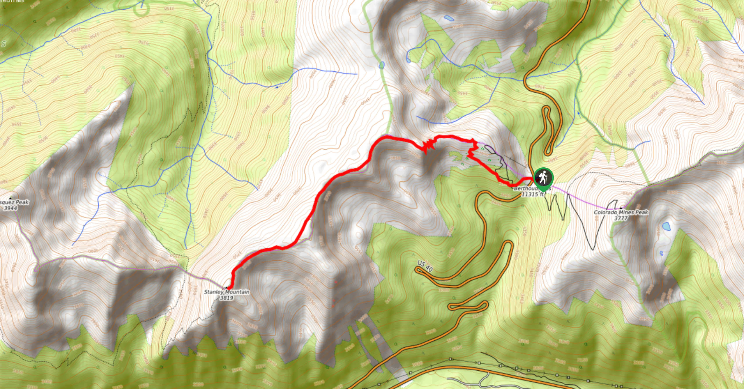
Embark on your adventure up the Mount Stanley Trail from the Berthoud Pass Parking Lot off W Park Avenue.

About
| Backcountry Campground | Dispersed Backcountry Camping, see rules and regulations. |
| When to do | March-October |
| Pets allowed | Yes - On Leash |
| Family friendly | No |
| Route Signage | Average |
| Crowd Levels | Moderate |
| Route Type | Out and back |
Mount Stanley Trail
Elevation Graph
Weather
Mount Stanley Hike Description
Add the Mount Stanley Trail to your Colorado itinerary right now, trust us. Hike up the Continental Divide and summit Stanley Mountain, where either the stunning views or the high altitude will take your breath away. The Mount Stanley Trail hikes up technical rocky terrain to summit the Pass, so make sure you are wearing sturdy shoes and consider bringing trekking poles. Because you will be ascending the Continental Divide and Stanley Mountain, you will need to check the weather prior to setting out. We recommend completing this hike in the morning to avoid getting caught in an afternoon lightning storm. Additionally, because of the extreme elevation, make sure you are acclimated to the area’s high elevation and bring plenty of water when attempting this feat. As always, wear layers to protect against the chilly wind.
Departing from the Berthoud Pass Parking lot, you will have to cross W Park Avenue to the Mount Stanley Trailhead. From here, take the Berthoud Pass West Trail. You will maintain this path for the entirety of the hike. Begin tracking through the wooded section of the trail-enjoy the tree coverage while you have it. As you climb, you will quickly ascend the timberline and the trail will become exposed. This section of the excursion is extremely steep and technical. Hike up the steep rocky trail and navigate the several sets of tightly wound switchbacks. Continue trekking up the path and you will summit the Divide. The trail will curve southwest as you hike along the ridge. Track across the ridge and admire the 360-degree views. Soon you will meet the base of Stanley Mountain.
Climb up the rocky terrain and summit Stanley Mountain. From here bask in the expansive views of the neighboring Front Range and the Continental Divide. Revel in the scenery before heading back. Retrace your steps along the ridge and down the Divide all the way back to the parking lot.
Similar hikes to the Mount Stanley Trail hike

Hankins Pass Hike
The Hankins Pass Hike is a quintessential adventure across the Lost Creek Wilderness. The hike demonstrates the diversity of the…

Miller Gulch Loop Trail
The Miller Gulch Loop Trail is a scenic meadowland adventure in the Pike National Forest. Hike through grassy meadows laden…

The Castle Hike
The Castle Hike is an exciting adventure up the steep, forested terrain to The Castle Rock. From atop the summit,…
Comments