
Gilpin Tramway Trail
View Photos
Gilpin Tramway Trail
Difficulty Rating:
The Gilpin Tramway Trail is a hike that will please outdoor enthusiasts and history buffs alike. Climb up the historical tramway path to the summit of Maryland Mountain. This path is a crowd favorite - hike it or bike it, this scenic and well-maintained adventure is sure to impress.
Getting there
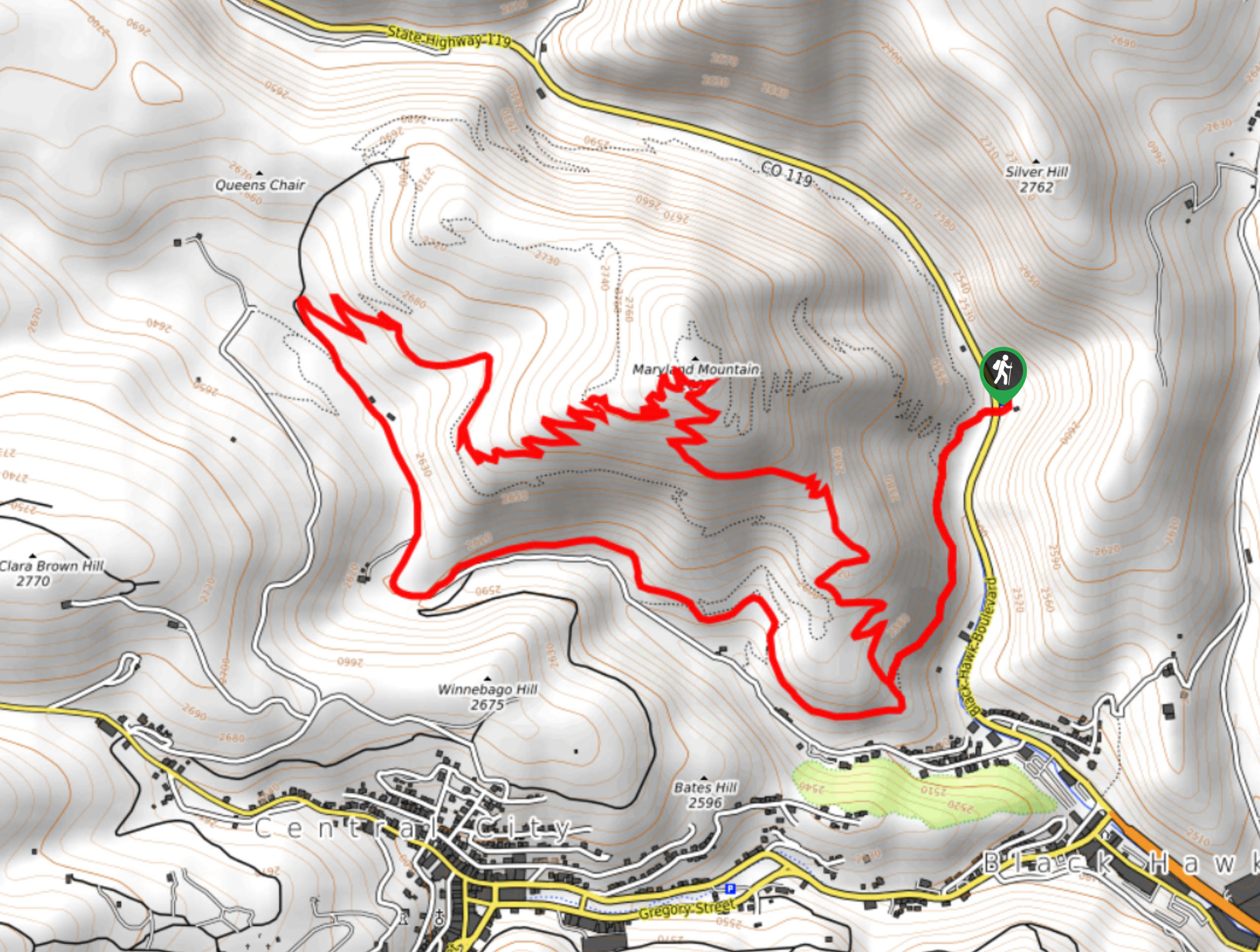
Find the Gilpin Tramway Trailhead off Black Hawk Boulevard.

About
| Backcountry Campground | No |
| When to do | April-October |
| Pets allowed | Yes - On Leash |
| Family friendly | Older Children only |
| Route Signage | Average |
| Crowd Levels | High |
| Route Type | Lollipop |
Gilpin Tramway Trail
Elevation Graph
Weather
Gilpin Tramway Trail Description
Immerse yourself in nature and travel back in time as you ascend the Gilpin Tramway Trail. The Gilpin Trailway operated from 1887 to 1917 to transport gold to and from remote regions. Now, a hiking trail has replaced the narrow trailway that outdoor enthusiasts can enjoy. Note there are steep segments of the trail and tightly wound switchbacks to the summit.
Begin your historical adventure up the Gilpin Tramway Trail from the parking lot. Note you will have to cross over Black Hawk Boulevard to access the trailhead. From the trailhead, track south along the Historic Gilpin Tramway Trail. Hike along the path, passing remnants from an old mine. This loop can be completed from either direction, but we prefer trekking clockwise. At the junction, keep left on the Historic Gilpin Tramway Trail. Maintain along this trail and keep left at the intersection with Paymaster Trail. At the next fork in the road, turn right onto Quartz Valley Trail.
At the next junction, veer right onto Paymaster Trail and navigate the switchbacks. Climb the route until you meet the next junction. Stay left on Claim Jumper Trail and navigate the steep set of switchbacks up to the summit of Maryland Mountain. Revel in the expansive views of the surrounding wilderness before tracking down the Summit Trail. Hike down the path and when you meet the intersection with the Historic Gilpin Tramway Trail, retrace your steps and head northeast back to the parking lot.
Similar hikes to the Gilpin Tramway Trail hike

Hankins Pass Hike
The Hankins Pass Hike is a quintessential adventure across the Lost Creek Wilderness. The hike demonstrates the diversity of the…

Miller Gulch Loop Trail
The Miller Gulch Loop Trail is a scenic meadowland adventure in the Pike National Forest. Hike through grassy meadows laden…

The Castle Hike
The Castle Hike is an exciting adventure up the steep, forested terrain to The Castle Rock. From atop the summit,…
Comments