
Fir Trail
View Photos
Fir Trail
Difficulty Rating:
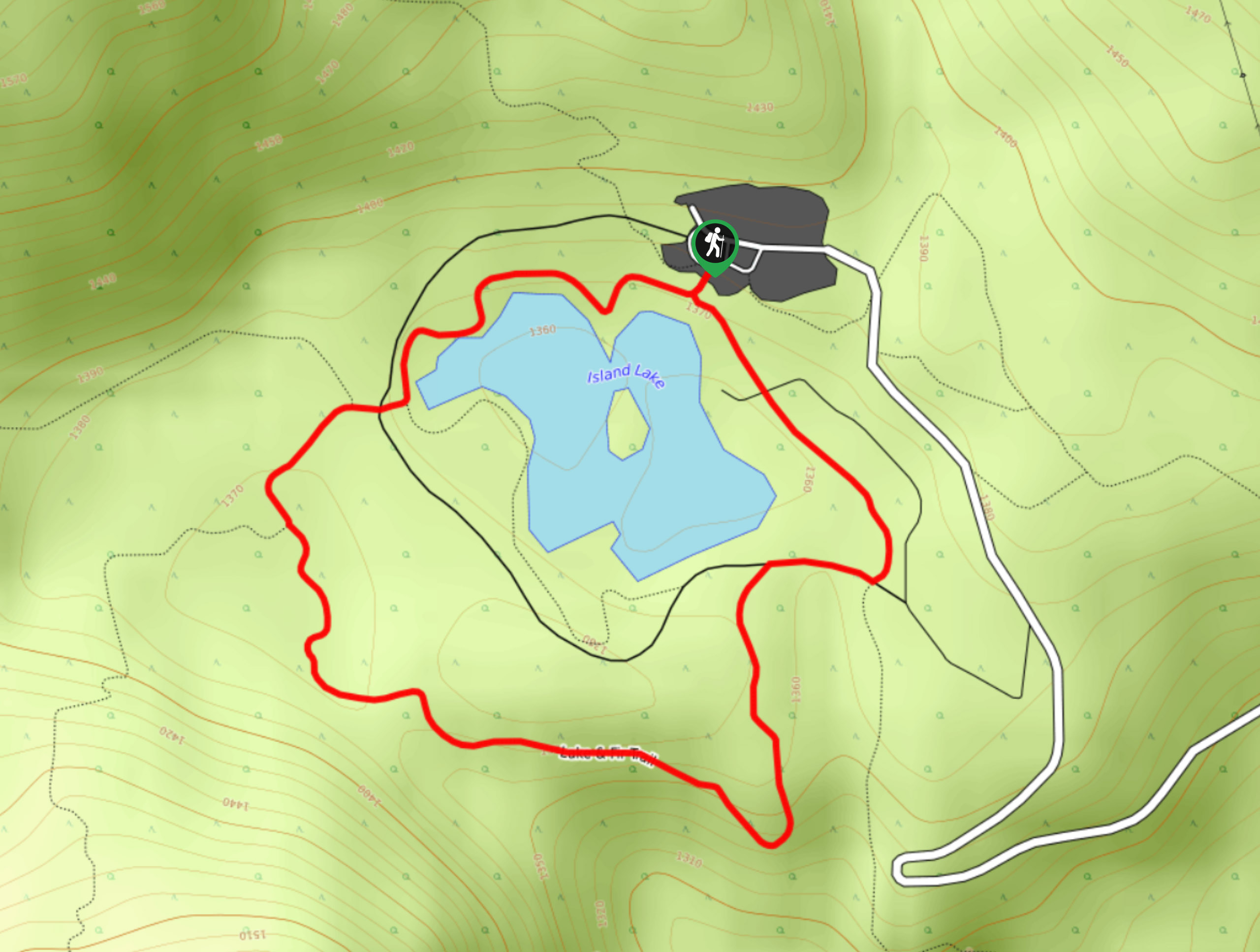
The Fir Trail is a 1.5mi circuit hiking route near Fernie, BC, that will take hikers on a scenic loop around the waters of Island Lake. With reasonably level terrain, beautiful views of the woodland landscape and surrounding mountains, and the chance to see wildlife, this is a great family-friendly hike that everyone can enjoy. Due to the frequency of bear sightings in the area, it is best to familiarize yourself with bear-safe hiking practices when setting out on this trail.
Getting there
To access the parking area for the Fir Trail from Fernie, make your way southwest on BC-3 for 1.5mi and make a right turn onto Mount Fernie Park Road. From here, continue for 5.8mi, and you will find the parking area on the right.

About
| When to do | June–October |
| Backcountry Campsites | No |
| Pets allowed | Yes - On Leash |
| Family friendly | Yes |
| Route Signage | Average |
| Crowd Levels | Moderate |
| Route Type | Circuit |
Fir Trail
Elevation Graph
Weather
Fir Trail Description
Hiking the Fir Trail is a fun, family-friendly activity in the Fernie area that will allow you to experience the natural beauty of the subalpine terrain around this beautiful lake. The trail traverses easy-to-navigate terrain and is accessible for hikers of all skill levels, including children and the elderly. Ensure to check the trail’s status before you head out on your hike, as access to the route is often restricted due to bear and moose activity in the area. Additionally, hikers should make sure to travel in groups, bring bear spray, and make lots of noise when out using this trail to avoid any potentially dangerous incidents.
From the parking area, the trail follows closely along the edge of the lake in a counterclockwise direction. A few side trails branch off from the Fir Trail Loop, so make sure to pay attention to trail signs and bring a map to stay on the correct course. Continue along the wooded shores of the lake and take in the glancing views of the nearby Lizard Mountain range before turning toward the east. When there are some breaks in the tree cover, you will have some spectacular views across the valley toward the majestic peak of Mount Fernie. As you wrap up the trail loop, you will pass through a beautiful stretch of old-growth forest before arriving back at the parking area.
Similar hikes to the Fir Trail hike
Montane Trail
The Montane Trail is a 3.1mi out-and-back trail used for several outdoor activities, including hiking, mountain biking, and…
Goldilocks Loop
The Goldilocks Loop is a 6.0mi lollipop hiking route near Fernie, BC, that sets out from the Island…
Gorby Trail Loop
The Gorby Trail Loop is a 3.4mi hiking route through Mount Fernie Provincial Park made up of several…
Comments