
Water Dog Reservoir via Crum Reservoir Trail
View Photos
Water Dog Reservoir via Crum Reservoir Trail
Difficulty Rating:
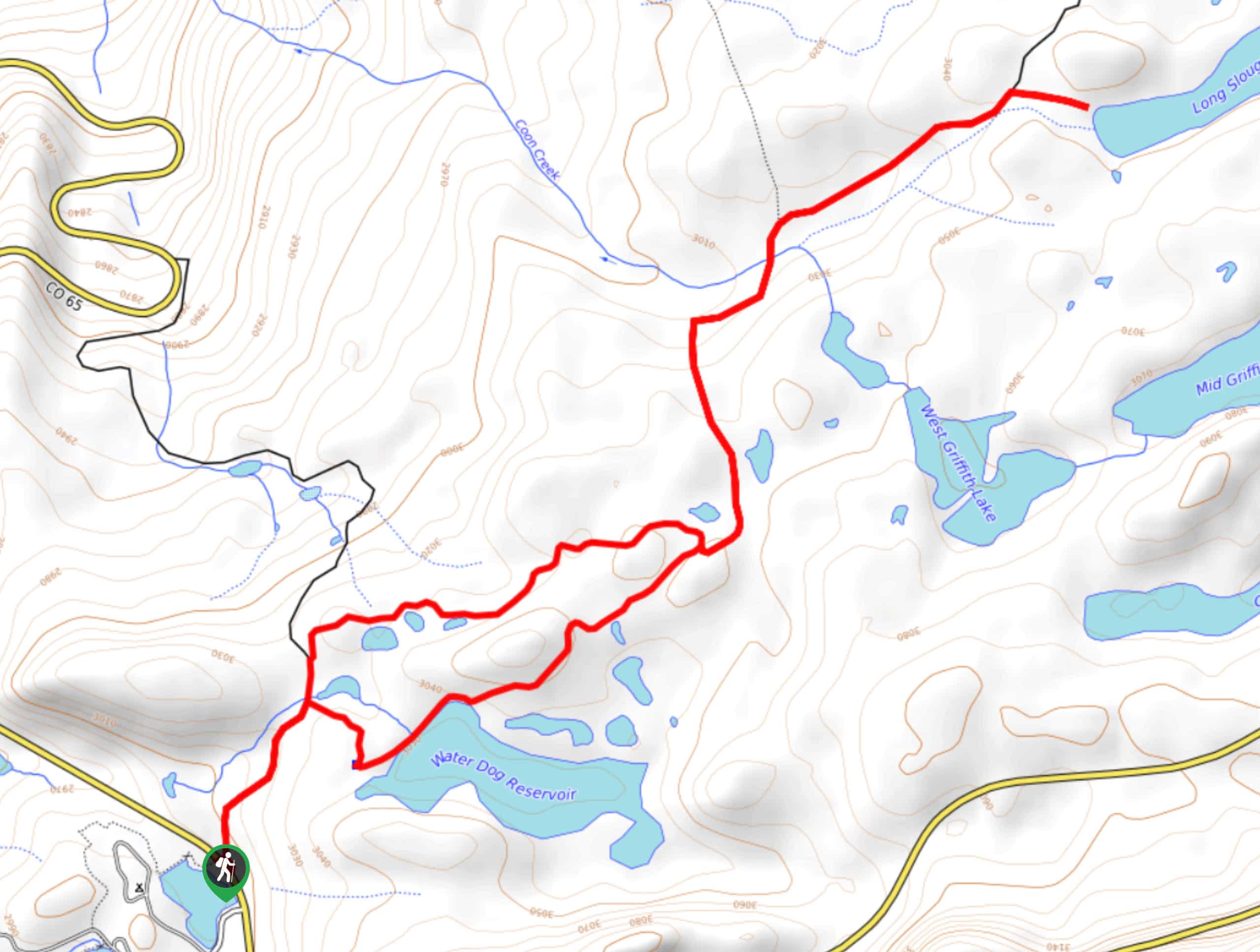
The Water Dog Reservoir via Crum Reservoir Trail is a pleasant hiking route near Mesa Lakes, Colorado that features several charming lakes and beautiful woodlands throughout. While out on the trail, you will follow along a forest service road that doesn’t offer much in the way of views, other than the odd view of a nearby lake through the tree cover. This trail is best suited for the fall season, when the changing colors of the foliage will create a beautiful backdrop for the hike.
Getting there
The starting point for the Water Dog Reservoir and Crum Reservoir Trail can be found at the car park next to Jumbo Reservoir along CR65.

About
| Backcountry Campground | No |
| When to do | April-October |
| Pets allowed | Yes - On Leash |
| Family friendly | Yes |
| Route Signage | Average |
| Crowd Levels | Moderate |
| Route Type | Lollipop |
Water Dog Reservoir via Crum Reservoir Trail
Elevation Graph
Weather
Water Dog Reservoir via Crum Reservoir Trail Description
If you aren’t concerned with hiking up to a breathtaking vista for incredible views, but would rather take a meandering stroll through a woodland landscape that offers little in the way of challenging terrain, then the Water Dog Reservoir via Crum Reservoir Trail might just be the perfect route for you.
Setting out from the car park next to Jumbo Reservoir, you will head across the highway and follow Fire Service Road 254 to the northeast. Keeping right at the first junction in the road, you skirt around the edge of Water Dog Reservoir and enjoy some nice views across the water, before continuing through the dense forest to the northeast.
Eventually, you will exit the tree cover and cross over Coon Creek, following the trail east through the meadow until you arrive at the edge of Long Slough Reservoir. After taking in the views, you will head back along the same route through the forest, keeping right at the fork just before Water Dog Reservoir in order to take an alternate route back to the car park where you began.
Similar hikes to the Water Dog Reservoir via Crum Reservoir Trail hike
Prospector Trail
The Prospector Trail is a fun hiking adventure near Crested Butte, Colorado that will take you uphill for beautiful views…
Lily Lake Trail #639
The Lily Lake Trail #639 is an easy-going hiking route in the Elk Mountains of Colorado that will lead you…
Green Lake via Carbon Trail
The Green Lake via Carbon Trail is an amazing experience in Crested Butte, Colorado that will take you to a…
Comments