
Mesa Creek #505 Trail
View Photos
Mesa Creek #505 Trail
Difficulty Rating:
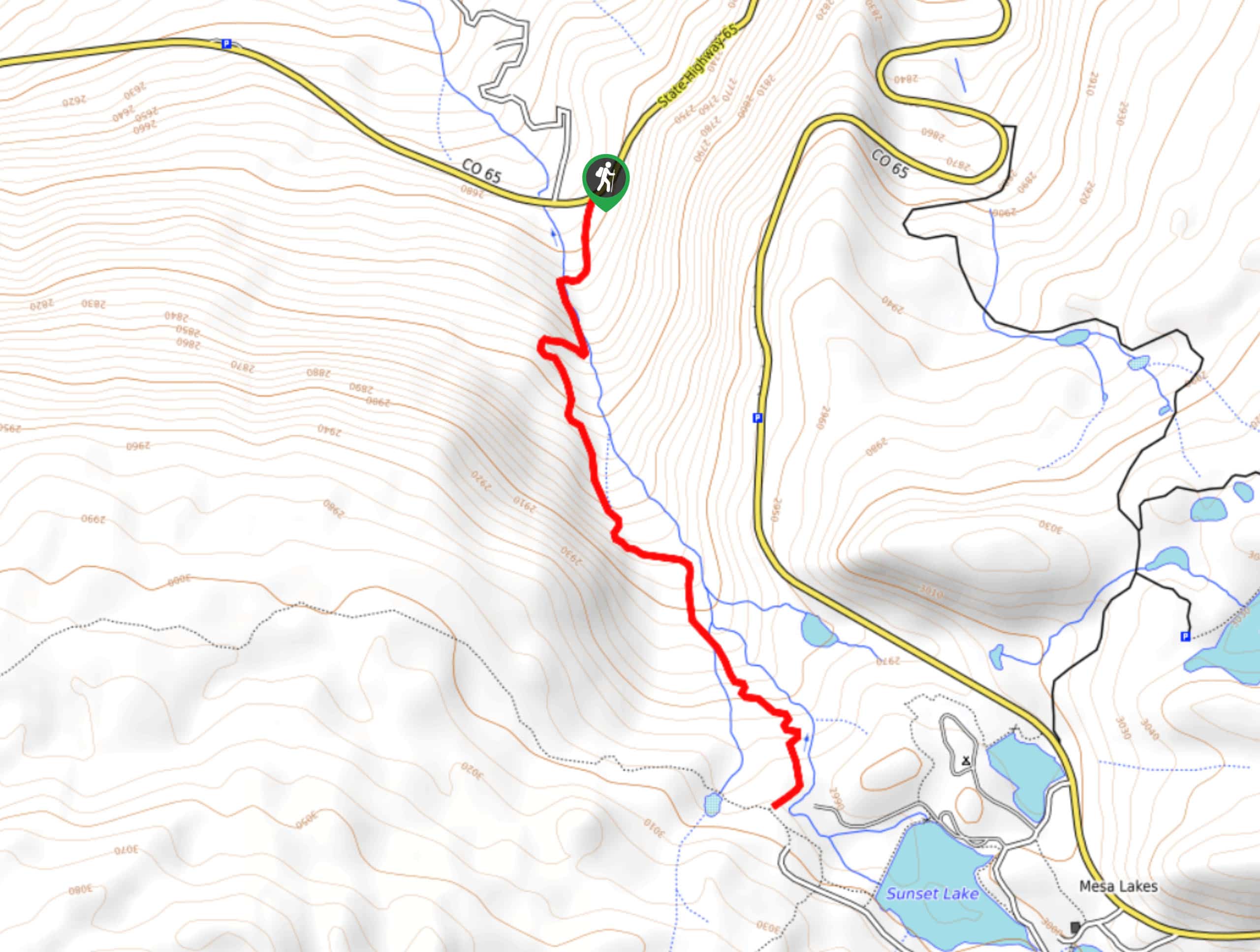
Hiking the Mesa Creek #505 Trail is a fantastic outdoor experience near Mesa Lakes, Colorado that will see you climb uphill through some steep terrain for lovely views of the aspen trees. While out on the trail, you will follow closely alongside the banks of Mesa Creek, enjoying the picturesque woodland surroundings before arriving at a junction with the West Bench Trail. There are several makeshift bridges to traverse, as well as a few light scrambles on the steeper portion of the trail, so be sure to wear proper hiking boots.
Getting there
The trailhead for the Mesa Creek #505 Trail can be found at a roadside parking area along CR65, 3.2mi northwest of Jumbo Campground.

About
| Backcountry Campground | No |
| When to do | April-October |
| Pets allowed | Yes - On Leash |
| Family friendly | Yes |
| Route Signage | Average |
| Crowd Levels | Moderate |
| Route Type | Out and back |
Mesa Creek #505 Trail
Elevation Graph
Weather
Mesa Creek #505 Trail Description
If you find yourself in the Mesa Lakes area and are looking for a challenging hiking route that isn’t overly long, the Mesa Creek #505 Trail is a great option. Featuring a lovely creekside setting, beautiful aspen trees, and some fairly steep terrain, this is a great trail for casual and seasoned hikers alike.
Setting out from the roadside trailhead, you will make your way past the information board in order to pick up the trail. Here, you will follow the path to the southwest and into the forest, where you will cross over to the opposite bank of Mesa Creek.
Following the creek to the southeast, you will begin climbing your way uphill through the streep terrain of the forest, enjoying the beautiful views of the surrounding aspen trees in the process. After the steep push along the final portion of the trail, you will pass by several small cabins and arrive at a junction with the West Bench Trail. From here, you will simply head back down the same route on the return leg through the forest to your vehicle.
Similar hikes to the Mesa Creek #505 Trail hike
Prospector Trail
The Prospector Trail is a fun hiking adventure near Crested Butte, Colorado that will take you uphill for beautiful views…
Lily Lake Trail #639
The Lily Lake Trail #639 is an easy-going hiking route in the Elk Mountains of Colorado that will lead you…
Green Lake via Carbon Trail
The Green Lake via Carbon Trail is an amazing experience in Crested Butte, Colorado that will take you to a…
Comments