
Rawhide Trail
View Photos
Rawhide Trail
Difficulty Rating:
The Rawhide Trail is an epic adventure through the White Ranch Open Space Park that attracts outdoor explorers of all types. Hike, bike, snowshoe, cross country ski or horse ride, this trail presents endless outdoor activities. The popularity of this hike is a testament to its incredible scenery and manageable terrain.
Getting there
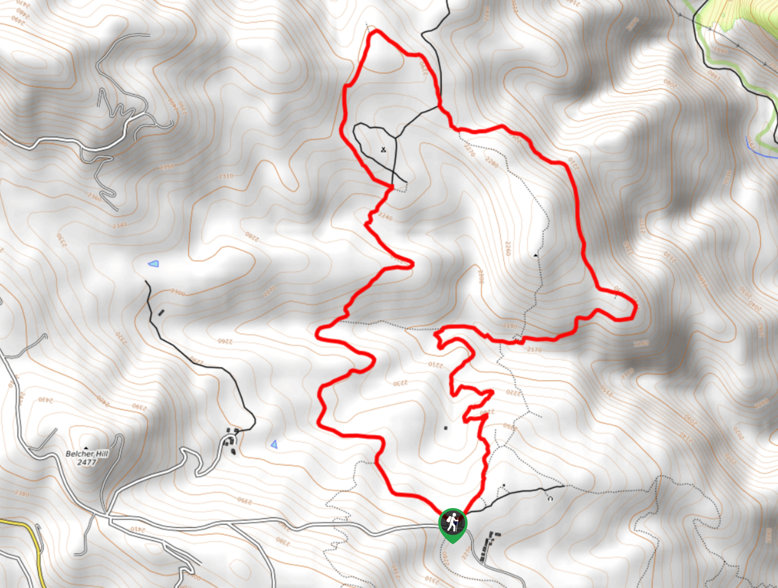
The Rawhide Trail is accessed via the trailhead off Belcher Hill Road.

About
| Backcountry Campground | Dispersed backcountry campsites |
| When to do | Reasonable start/end dates for route |
| Pets allowed | Yes - On Leash |
| Family friendly | Yes |
| Route Signage | Average |
| Crowd Levels | High |
| Route Type | Circuit |
Rawhide Trail
Elevation Graph
Weather
Rawhide Trail Description
The Rawhide Trail is a crowd favorite, and rightfully so. Enjoy the diversity of the terrain and the epic views of the Colorado wilderness along this superb trail. Socialize with like-minded adventurers as you trek along the route and enjoy the stunning scenery. With the perfect amount of elevation, this path will get your heart rate up without over-exhausting you! It is worth noting that there are rattlesnakes in the area, so if you choose to hike in the summer months make sure to keep an eye and ear out for them.
From the trailhead, keep left and track northwest along the Rawhide Trail. Hike along the undulating path through meadowlands and pine forests. Soon you will encounter an intersection, keep left along the Rawhide Trail. Pass the dispersed campsites and trek further into the wilderness. Eventually, you will encounter a bench that presents stunning views of the encompassing rolling hills. From this point, the route will begin to curve south as you begin your return to the trailhead. You will meet another intersection, keep left here, traveling through the woodlands.
Enjoy the scenery as you complete the last leg of your excursion. Follow the Rawhide Trail south all the way back to the trailhead, marking the end of your awesome adventure.
Similar hikes to the Rawhide Trail hike

Singletree and Mayhoffer Trail
The Singletree and Mayhoffer Trail is a scenic adventure that will guide adventurers through the lush meadowlands that reveal sights…
Hidden Fawn Loop Trail
The Hidden Fawn Loop Trail is a lovely meadowland adventure in the Alderfer/Three Sisters Open Space Park. Enjoy sights of…

Mount Galbraith via Cedar Gulch Trail
The Mount Galbraith via Cedar Gulch Trail is a charming adventure near Golden, Colorado that reveals the beauty and diversity…
Comments