
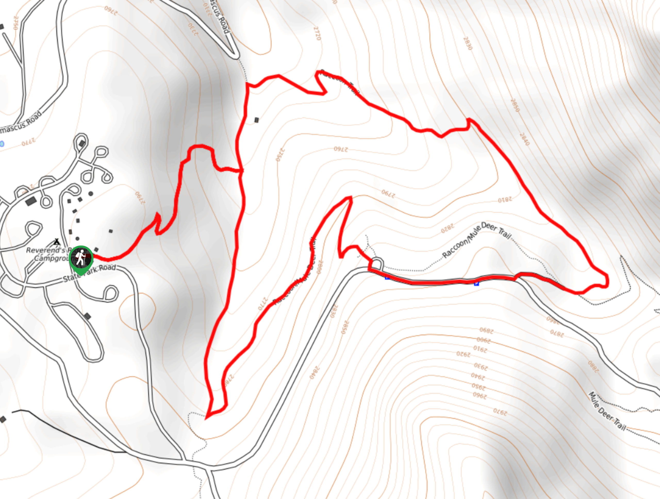
Racoon Trail
View Photos
Racoon Trail
Difficulty Rating:
Just minutes away from Denver, the Racoon Trail traverses through dense pine woodlands and aspen groves to a panoramic mountain overlook. Located within the Golden Gate Canyon State Park, the path is well-maintained, well-signposted, and is perfect for a family adventure into nature. Escape the hustle and bustle of the real world and escape into the Colorado wilderness.
Getting there
The Racoon Trail departs from Reverend Ridge Campground in the Golden Gate Canyon State Park.

About
| Backcountry Campground | |
| When to do | April-October |
| Pets allowed | Yes - On Leash |
| Family friendly | Yes |
| Route Signage | Good |
| Crowd Levels | Extreme |
| Route Type | Lollipop |
Racoon Trail
Elevation Graph
Weather
Racoon Trail Description
The Racoon Trail is a charming loop hike in the Golden Gate Canyon State Park that reveals stunning natural scenery so close to the state’s capital. The convenient proximity of the trail to Denver means that it is often highly trafficked. If you are in search of a secluded nature hike, then you may want to consider another route. If you are committed to hiking the scenic Racoon Trail, then consider an early morning weekday adventure to avoid the crowds! The crowds prove the awesomeness of the hike, but it also increases the annoyances of parking. The limited parking lot at the trailhead fills up fast, so arrive in the early morning to secure a spot. Note visitors are required to pay a $10USD entrance fee to get into the park. Additionally, there are park rangers that man the trailhead to regulate crowds in the area.
If you are lucky enough to secure a parking spot, then you are in for a treat. The Racoon Trail is a scenic adventure that exhibits the diversity of the Colorado wilderness. As you hike along the mildly undulating path, you will trek through dense woodlands, luxuriant meadows, and past scenic overlooks. Great for families and novice hikers, this trail reveals epic sights that are usually reserved for technical summits. Enjoy up close and personal views of Tremon Mountain and Denver, plus sights of the Front Range snow-capped peaks from the Panoramic Point overlook. Though this path is accessible year-round, we recommend hiking in the autumn to enjoy views of the vibrant golden aspens that line the path. Either way, whenever you venture this path, we know you will enjoy it just as much as we do.
Begin your excursion along the Racoon Trail from the Reverend Ridge Campground. From here, track east along the connector trail to the loop’s junction. At the intersection, you can choose to complete the circuit from either direction, but we usually trek counterclockwise. So, turn right and you will be diverted onto the Racoon Trail. Hike through the pine trees and aspen groves to the next intersection. From here, take a sharp left turn down the Racoon- Mule Deer Trail. This path will guide you along the base of Tremont Mountain.
Trek along the base of the summit to Panorama Point. From Panorama Point, you will be rewarded with views of the Front Range snow-dusted peaks, including Long Peak and Pikes Peak in the northwest and sights of Denver in the east. Revel in the grandeur of Colorado’s mountainous wilderness before continuing your venture. Follow the Racoon- Mule Deer Trail until the next junction. At this point, keep left, reconnecting with the Racoon Trail. Hike along this route that weaves through pine woodlands interspersed with vibrant aspens. The path will lead you northwest before curving south back to the loop’s junction. From here, retrace your steps along the connector route back to the campground, marking the end of your nature excursion!
Trail Highlights
Tremont Mountain
Tremont Mountain is the tallest summit in the Golden Gate Canyon State Park. Sitting at an elevation of 10388ft, the mountain ranks 2091st on the list of Colorado summits. Though not the tallest peak, Tremont Mountain rewards those who summit with expansive views of the Front Range peaks, including Longs Peak and Pikes Peak in the northwest. Located in the northeastern corner of Gilpin County, the peak also reveals views of Thorodin Mountain and Denver in the east. There is no explicit trail up to the summit of Tremont Mountain, but many scramble up the secluded ridge up to the granite outcroppings atop the summit.
Frequently Asked Questions
Are dogs allowed on the Racoon Trail?
Yes, dogs are allowed on the Racoon Trail if they remain on-leash.
Is there a fee to enter the Golden Gate Canyon State Park?
Yes, the Golden Gate Canyon State Park charges an entrance fee which typically costs around $10USD.
Insider Hints
Trade your hiking shoes for snowshoes in the winter months
This is a heavily trafficked route; thus, dogs must remain on leashes the entirety of your hike
If you are feeling adventurous, consider off-roading to ascend Tremont Mountain
Hike in the fall and revel in the vibrance of the golden aspen groves
Similar hikes to the Racoon Trail hike

Singletree and Mayhoffer Trail
The Singletree and Mayhoffer Trail is a scenic adventure that will guide adventurers through the lush meadowlands that reveal sights…
Hidden Fawn Loop Trail
The Hidden Fawn Loop Trail is a lovely meadowland adventure in the Alderfer/Three Sisters Open Space Park. Enjoy sights of…

Mount Galbraith via Cedar Gulch Trail
The Mount Galbraith via Cedar Gulch Trail is a charming adventure near Golden, Colorado that reveals the beauty and diversity…
Comments