
North Table Mountain and Rim Rock Loop
View Photos
North Table Mountain and Rim Rock Loop
Difficulty Rating:
North Table Mountain and Rim Rock Loop is a scenic adventure up to the summit of the mesa. North Table Mountain is a prominent feature protruding out of the Colorado landscape and the flat summit is truly intriguing. This geological piece presents endless activities for intrepid adventurers. Sitting on the eastern edge of the Front Range foothills, the summit provides expansive views of the rolling mountains and distant view of Denver. Whether you hike, climb, snowshoe, or bike the trails, you will be dumbfounded by the impressive summit views.
Getting there
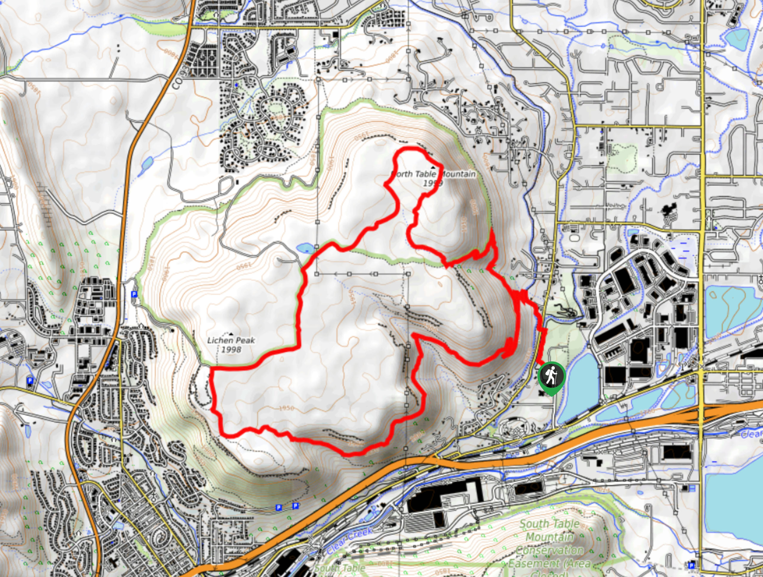
The North Table Mountain and Rim Rock Loop departs from the Golden Open Space Trailhead off Salvia Street in Golden, Colorado.

About
| Backcountry Campground | No |
| When to do | Year-round |
| Pets allowed | Yes - On Leash |
| Family friendly | Older Children only |
| Route Signage | Average |
| Crowd Levels | Extreme |
| Route Type | Lollipop |
North Table Mountain and Rim Rock Loop
Elevation Graph
Weather
North Table Mountain and Rim Rock Loop Description
The North Table Mountain and Rim Rock Loop is an unforgettable adventure. Hike up the craggy mountain side to the flattop summit that has an environment of its own. This trail is one of the most popular day hikes near Denver, and rightfully so – be prepared to share the trail with fellow adventurers! The arid and sunny terrain is inviting to rattlesnakes, so keep an eye and ear out for them as you hike.
Loose fitting pants may also be a good idea. It is also worth noting that the path can be muddy, so consider leaving your new white runners at home for this one! Additionally, the network of trails is almost entirely exposed to the elements, so expect sunny and windy conditions from atop the mesa. It is also important to check the bulletin at the trailhead as the area is subject to closure due to raptor nesting.
Not only does the summit hike bring windy weather, but it presents epic Colorado vistas. The North Table Mountain and Rim Rock Loop exhibits the diversity of the Colorado landscape. From the summit, revel in the views of grassy arid plains in the east, the Flatiron Mountains in the north, and the snow-dusted craggy peaks that flank verdant woodlands in the west. It is undeniable that this hike rewards unparalleled views, but it also presents plenty of opportunities to see wildlife. The hike around the summit is notorious for elk and deer sightings, so keep an eye out for them as you trek! Whether you hike it in the winter or summer, we know you will be just as impressed as we were by the North Table Mountain and Rim Rock Loop.
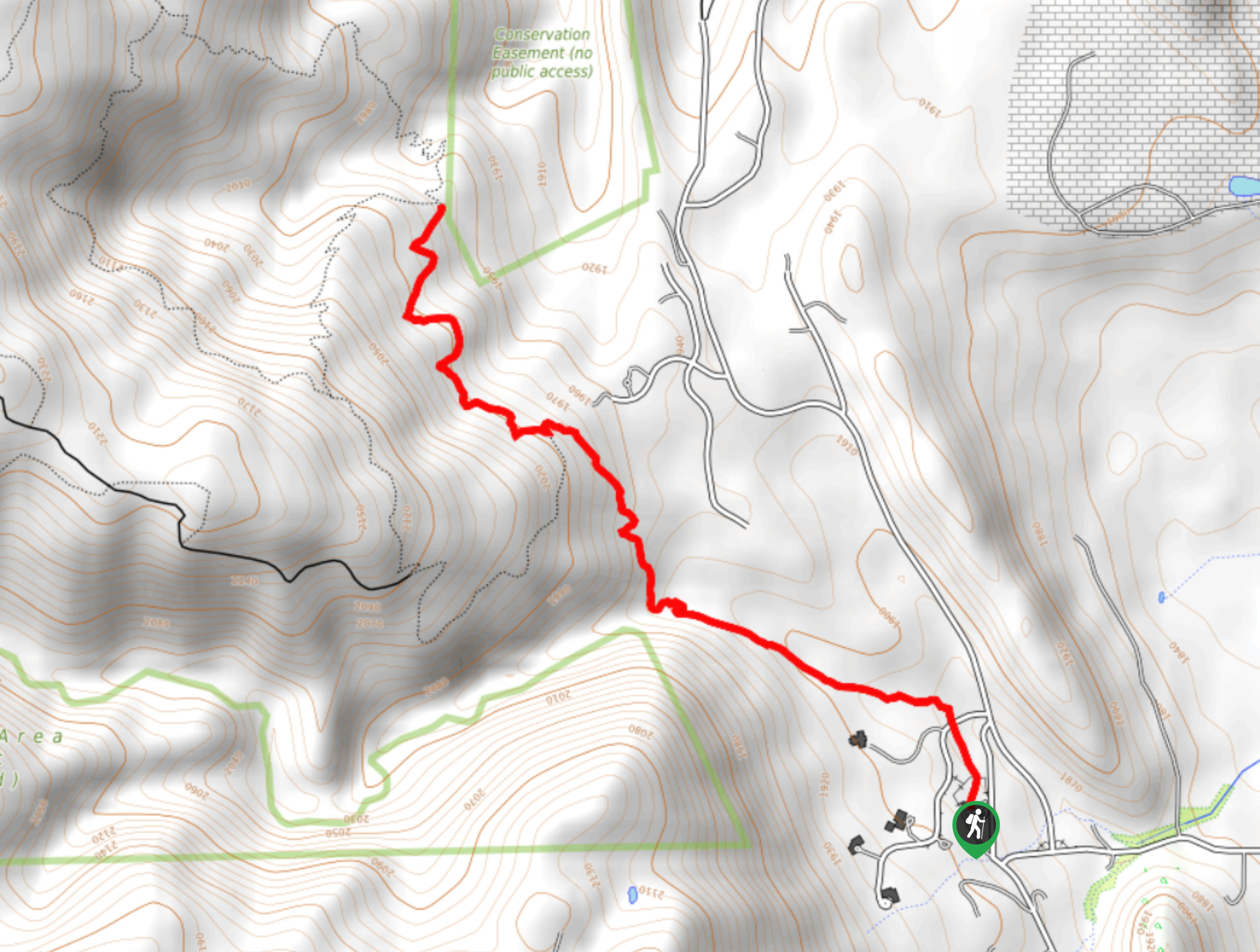
Your adventure around the North Table Mountain and Rim Rock Loop begins from the Golden Open Space Trailhead. From here, track north along the Golden Open Space Trail. Hike along Church Ditch before crossing Easley Road, where you will merge onto the Fairmont Canal Trail. Trek along the canal, and at the next intersection, turn left and ascend a set of switchbacks. After navigating the winding terrain, you will be confronted with another junction, turn right and you will be diverted onto the North Table Loop Trail. Notice rock climbers on the cliff face as you track north along the dirt path. After crossing a stream, you will meet another intersection, take a sharp left and ascend the steep terrain.
Hikers will encounter another junction after ridging the summit, stay right here and walk along the Rim Rock Trail. Hike north along the path to North Table Mountain. Enjoy the expansive vistas of the mountainous wilderness and distant views of Denver. From here the route will curve you southwest along the summit. At the next fork in the road, keep right on the Mesa Top Trail and before veering left along the Tilting Mesa Trail. Eventually you will encounter another intersection near Lichen Peak. At this point you are going to want to turn left, reconnecting with the North Table Loop Trail.
Hike the North Table Loop Trail along the western edge of the mesa. Here you may also spot daring rock climbers. Follow this path as it guides you southeast down the mesa. Hike along the ridge of the mountain, noticing the trains running below. The path will intersect with a few creeks and merging routes as you descend the ramp. Eventually, you will be delivered back to the initial intersection with the Fairmont Canal Trail. From here, turn right and carefully navigate the switchbacks down to the canal, and simply retrace your footing along the path back to the trailhead.
Trail Highlights
North Table Mountain
North Table Mountain is a mesa on the eastern edge of the Front Range. Sitting at approximately 6,555ft in elevation, the mesa’s prominence is nothing to write home about, but its unique geological formation is. The flattop mesa was formed by Palaeocene lava flows millions of years ago and there sits a South Table Mountain not too far away. These anomalies are now home to popular networks of trails and several varieties of wildlife. The North Table Mountain is worth adventuring when in the Denver area.
Frequently Asked Questions
Is the North Table Mountain and Rim Rock Loop challenging?
The answer is subjective, if you have hiking experience and are fit, you should be ok and able to summit the mountain.
Are dogs permitted on the North Table Mountain and Rim Rock Loop Hike?
Yes, dogs are permitted on the North Table Mountain and Rim Rock Loop Trails if they remain on leash.
Insider Hints
Rattlesnakes are abundant in this area, wear loose pants and keep an eye and ear out for them
The exposed terrain at the summit warrants overexposure, so wear a sunhat and sunscreen in the summer months
Though you can venture the trail year-round, the wildflowers in the spring and summer are incredible
Grab a beer at the New Terrain Brewing Company after your hike
Similar hikes to the North Table Mountain and Rim Rock Loop hike

Singletree and Mayhoffer Trail
The Singletree and Mayhoffer Trail is a scenic adventure that will guide adventurers through the lush meadowlands that reveal sights…

Mount Galbraith via Cedar Gulch Trail
The Mount Galbraith via Cedar Gulch Trail is a charming adventure near Golden, Colorado that reveals the beauty and diversity…
Belcher Hill and Whippletree Trail
The Belcher Hill and Whippletree Trail is an exciting adventure—how could it not be with a name like that? The…
Comments