
Mountain Lion Trail
View Photos
Mountain Lion Trail
Difficulty Rating:
Don’t worry, the Mountain Lion Trail is not nearly as frightening as the name depicts, though there is a possibility of encountering wildlife. Don’t let the name discourage you, the Mountain Lion Trail is one of the most scenic hikes near Denver in our opinion. This wonderful adventure guides hikers though diverse terrains and reveals epic mountain vistas. Trek the Mountain Lion Trail as a day-hike or an overnight backpacking expedition, either way you will be impressed,
Getting there
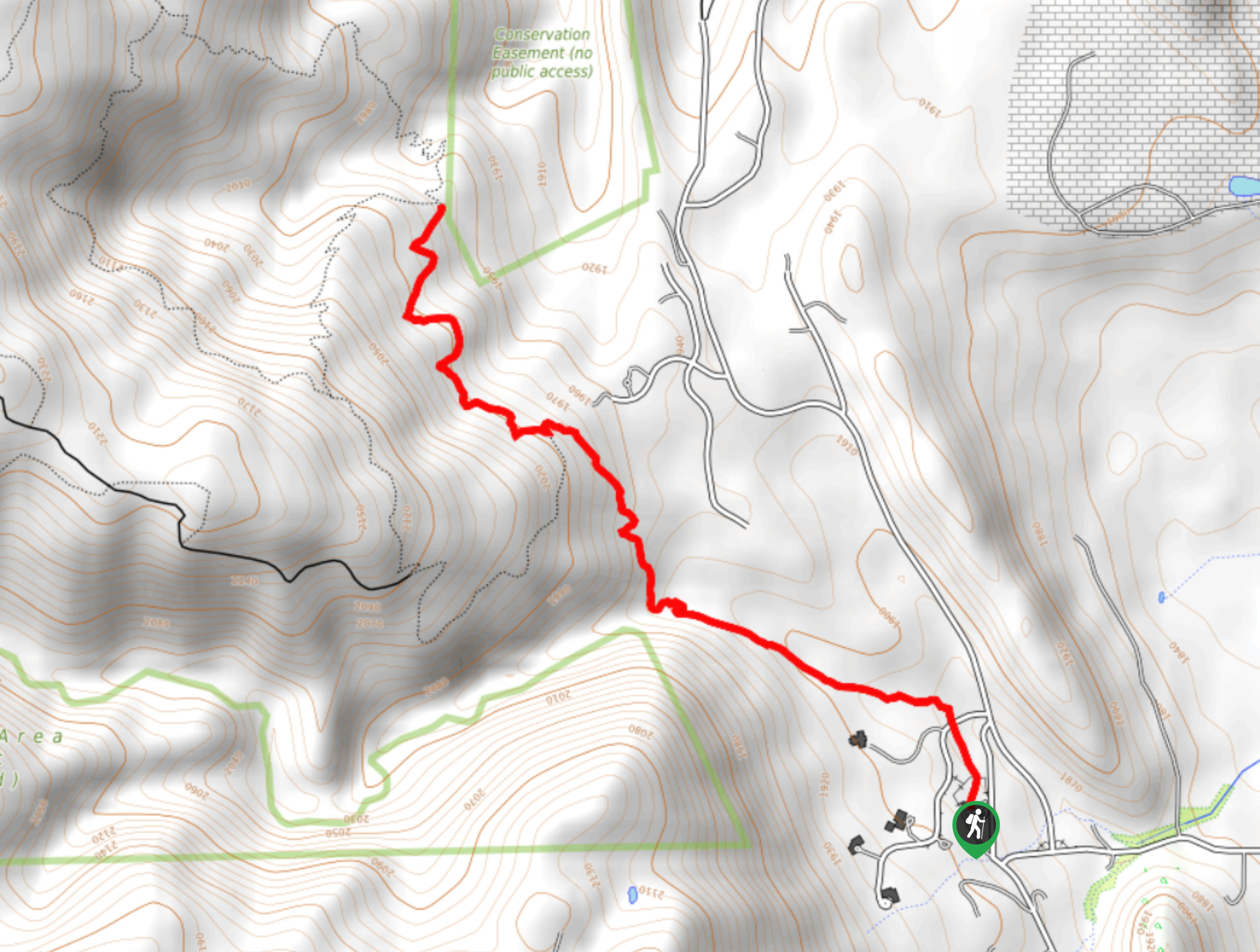
The Mountain Lion Hike departs from the trailhead off Drew Hill Road in the Golden Gate Canyon State Park.

About
| Backcountry Campground | Forgotten Valley Campground/Deer Creek Campground |
| When to do | Year-round |
| Pets allowed | Yes - On Leash |
| Family friendly | Older Children only |
| Route Signage | Average |
| Crowd Levels | High |
| Route Type | Circuit |
Mountain Lion Trail
Elevation Graph
Weather
Mountain Lion Trail Descritpion
The Mount Lion Trail is an unassumingly picturesque adventure in the Golden Gate Canyon State Park. Travel through various terrains that reveal the beauty of the Colorado wilderness. This epic excursion is popular, notably among Denverites who escape the city on the weekend and head out into nature. If you are seeking a secluded hike, we would recommend heading out in the early morning or on weekdays! This lovely walk travels through the wilds, so keep an eye out for wildlife including deer, elk, bear, and mountain lions. Consider wearing a bear bell and maintain a safe distance from the animals if you do cross paths! Traveling through different terrains warrants changing weather conditions, so wear layers as insurance against chilly weather! Though this path is accessible year-round, the terrain can be icy and rugged in the winter months, so we recommend summer or autumn hikes. If you adventure in the fall, you will also be rewarded with epic views of the vibrant aspen trees, which are our favorite! Located within the Golden Gate Canyon State Park, visitors are required to purchase a day pass which typically costs around $6USD.
The Mountain Lion Trail is all the quintessential Colorado Hikes wrapped into one. Cross creeks and travel through meadowlands, aspen groves, dense pine woodlands, and scenic mountainous overlooks. This excursion packs a punch, and we couldn’t recommend it enough! This charming nature walk is ideal for those easing into Front Range adventures; the elevation gain and various terrains will get your heart pumping but won’t over-exhaust you! Novice hikers and older children should be able to easily manage this hike as the well-maintained paths, and lack of technical ascents boasts a relaxing adventure. What better way is there to explore the Colorado wilderness than you hike the Mountain Lion Trail that exhibits the area’s diversity? We love this trail, and we know you will too, so what are you waiting for? Lace up those hiking shoes and head out!
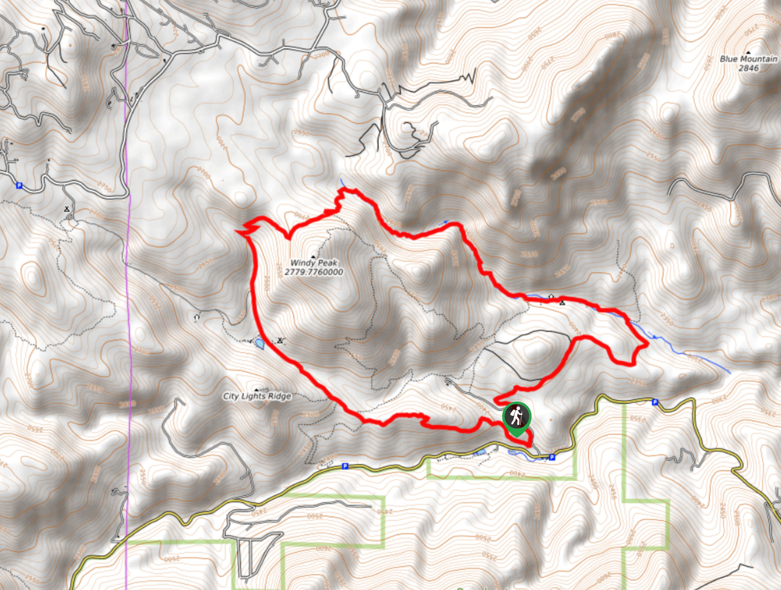
Embark on your journey along the Mountain Lion Trail from the trailhead off Drew Hill Road. You can complete the loop from either direction, but we headed counterclockwise on this one. Departing from the trailhead, track north along the Mountain Lion Trail. This segment of the excursion will guide you through the meadowlands, exposing awesome views of the snow-dusted Front Range peaks that line the horizon. As the path curves you east, continue along to an intersection with the Quarry Trail at Deer Creek. At this point, keep left, following the Mountain Lion Trail beneath the tree shade.
This section of the adventure travels along the beautiful, forested path, through cedar groves, and along the babbling waters of Deer Creek. Soon after leaving the junction, hikers will pass the Deer Creek Dispersed Campsites, nestled amongst the towering trees. Follow the path, staying right at the next intersection. As the trail gently ascends towards Windy Peak, the path will weave between meadows and tree shade. Enjoy the ambiance of the running waters as you hike and take your time, taking breaks as needed.
The trail will eventually guide you southwest and through a set of mild switchbacks along the ridge of Windy Peak. Follow the densely wooded path through pines interspersed with aspen groves. At the next junction, you can keep straight along the Mountain Lion Trail or take a quick detour up the Mountain Lion Spur Trail to the summit of Windy Peak, which reveals epic mountainous vistas. Either way, continue west along the Mountain Lion Trail. The terrain will be rocky as you descend the mountain ridge, so mind your footing. The path will become increasingly exposed with limited tree shade from this point forward.
Continue hiking along this route as it curves you south, down to Knott Creek and the Tallman Ranch Homestead. Explore the historical buildings and take a break before your final push back to the trailhead. Follow the Mountain Lion Trail through the Forgotten Valley and past the dispersed campsites. Now traveling southeast, the trail will weave you between tree coverage and exposed meadowlands. Ignore merging paths and revel in the views of the Front Range Foothills as you hike through the grassy plains. Eventually, the Mountain Lion Trail will guide you back to the trailhead, marking the end of your Golden Gate Canyon State Park adventure!
Trail Highlights
Windy Peak
Windy Peak is a small mountain that sits in the northeast corner of the Golden Gate Canyon State Park. Part of the Front Range, Windy Peak sits at an unimpressive elevation of 9141ft. Though not the grandest peak in the Front Range, the rocky outcropping reveals expansive views of the Continental Divide, Indian Peaks Wilderness, and distant views of Denver. Ranking as the 2,841st highest mountain in Colorado, the unassumingly scenic summit boasts epic vistas. Don’t get it confused with the other Windy Peak in the Front Range, though! The other Windy Peak sits in the Front Range in the Lost Creek Wilderness which peaks at an elevation of 11970ft, just a hair taller than the Golden Gate Canyon State Park’s!
Frequently Asked Questions
Is there a fee to hike the Mountain Lion Trail?
Yes, the Mountain Lion Trail is located within the Golden Gate Canyon State Park; thus, visitors must purchase a day pass which typically cost around $6USD
Are dogs permitted on the Mountain Lion Trail?
Yes, dogs are permitted in the Gold Gate Canyon State Park and along the Mountain Lion Trail.
Insider Hints
Consider attaching a bear bell to your pack to deter any unwanted encounters with wildlife
Microspikes or snowshoes are necessary when trekking this path in the winter months
Wear layers as the changing terrain warrants diverse weather conditions
Hike in the autumn to enjoy the aspens at peak vibrance
Similar hikes to the Mountain Lion Trail hike

Singletree and Mayhoffer Trail
The Singletree and Mayhoffer Trail is a scenic adventure that will guide adventurers through the lush meadowlands that reveal sights…

Mount Galbraith via Cedar Gulch Trail
The Mount Galbraith via Cedar Gulch Trail is a charming adventure near Golden, Colorado that reveals the beauty and diversity…
Belcher Hill and Whippletree Trail
The Belcher Hill and Whippletree Trail is an exciting adventure—how could it not be with a name like that? The…
Comments