
Mesa Top and Cottonwood Canyon Trail
View Photos
Mesa Top and Cottonwood Canyon Trail
Difficulty Rating:
Stunning overlooks, lush meadows, and gurgling streams, the Mesa Top and Cottonwood Canyon Trail is a great nature walk near the city. Get in your daily movement while hiking up a unique geological feature that reveals epic panoramic views. Revel in the scenery of the Front Range foothills and sights of the cityscape from atop the flattop summit.
Getting there
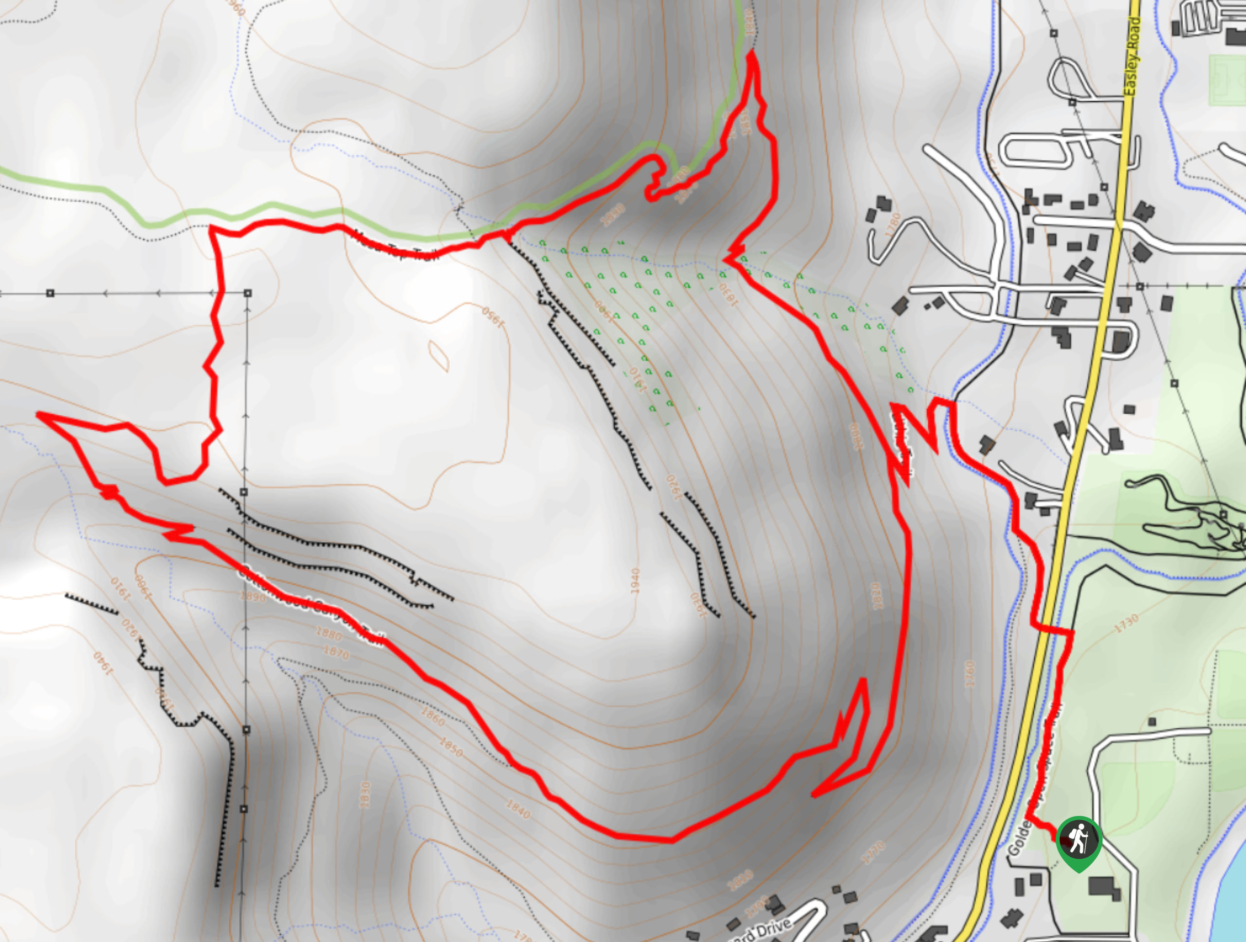
The Mesa Top and Cottonwood Canyon Trail departs from the Golden Open Space Trailhead off Salvia Street.

About
| Backcountry Campground | No |
| When to do | April-September |
| Pets allowed | Yes - On Leash |
| Family friendly | Yes |
| Route Signage | Poor |
| Crowd Levels | High |
| Route Type | Lollipop |
Mesa Top and Cottonwood Canyon Trail
Elevation Graph
Weather
Mesa Top and Cottonwood Canyon Trail Description
The Mesa Top and Cottonwood Canyon Trail is a crowd favorite, and there is no doubt as to why. The versatility of the trail, the stunning vistas, and the convenience of its location attracts outdoor enthusiasts of all sorts. Though this trail can be hiked or biked, it is worth noting that there are often more bikers, so keep an ear out for them as they pass by. This hike is also entirely exposed, so be prepared for incredibly warm conditions in the hot summer afternoons—if you can, head out in the early morning. Additionally, rattlesnakes are abundant in this area, so keep an eye and ear out for them as you hike.
Embark on your adventure along the Mesa Top and Cottonwood Canyon Hike from the trailhead. From here, track north along the Golden Open Space Trail before merging onto the Fairmont Canal Trail. This path will guide you over Church Ditch and Easley Road. Hike near the canal then cross the waters, turning onto the Lithic Trail. Navigate switchbacks up to the next intersection. From here, turn right onto the North Table Loop Trail. Enjoy sights of the towering cliffs and at the next junction, turn left onto the Mesa Top Trail.
Trek along this route, reveling in the sights of the rolling hills and snow-capped Front Range peaks that distantly line the horizon. At the intersection with Cottonwood Canyon Trail, turn left. This path will guide you down the Cottonwood Canyon and along the babbling creek. Revel in the grandeur of the encompassing towering walls. At the fork in the road, merge back onto the North Table Loop Trail. Hike this route all the way back to the junction with the Lithic Trail. From here, simply retrace your steps from the Lithic Trail all the way back to the trailhead.
Similar hikes to the Mesa Top and Cottonwood Canyon Trail hike

Singletree and Mayhoffer Trail
The Singletree and Mayhoffer Trail is a scenic adventure that will guide adventurers through the lush meadowlands that reveal sights…
Hidden Fawn Loop Trail
The Hidden Fawn Loop Trail is a lovely meadowland adventure in the Alderfer/Three Sisters Open Space Park. Enjoy sights of…

Mount Galbraith via Cedar Gulch Trail
The Mount Galbraith via Cedar Gulch Trail is a charming adventure near Golden, Colorado that reveals the beauty and diversity…
Comments