Longhorn and Shorthorn Hike
View Photos
Longhorn and Shorthorn Hike
Difficulty Rating:
Immerse yourself in the Colorado wilderness as you venture the Longhorn and Shorthorn Trail. Hike amongst like-minded outdoor enthusiasts as you trek this popular route. Whether you hike, bike, snowshoe, or run, you can enjoy this versatile trail year-round. Reconnect with nature and escape the stressors of city life on the Longhorn and Shorthorn Trail.
Getting there
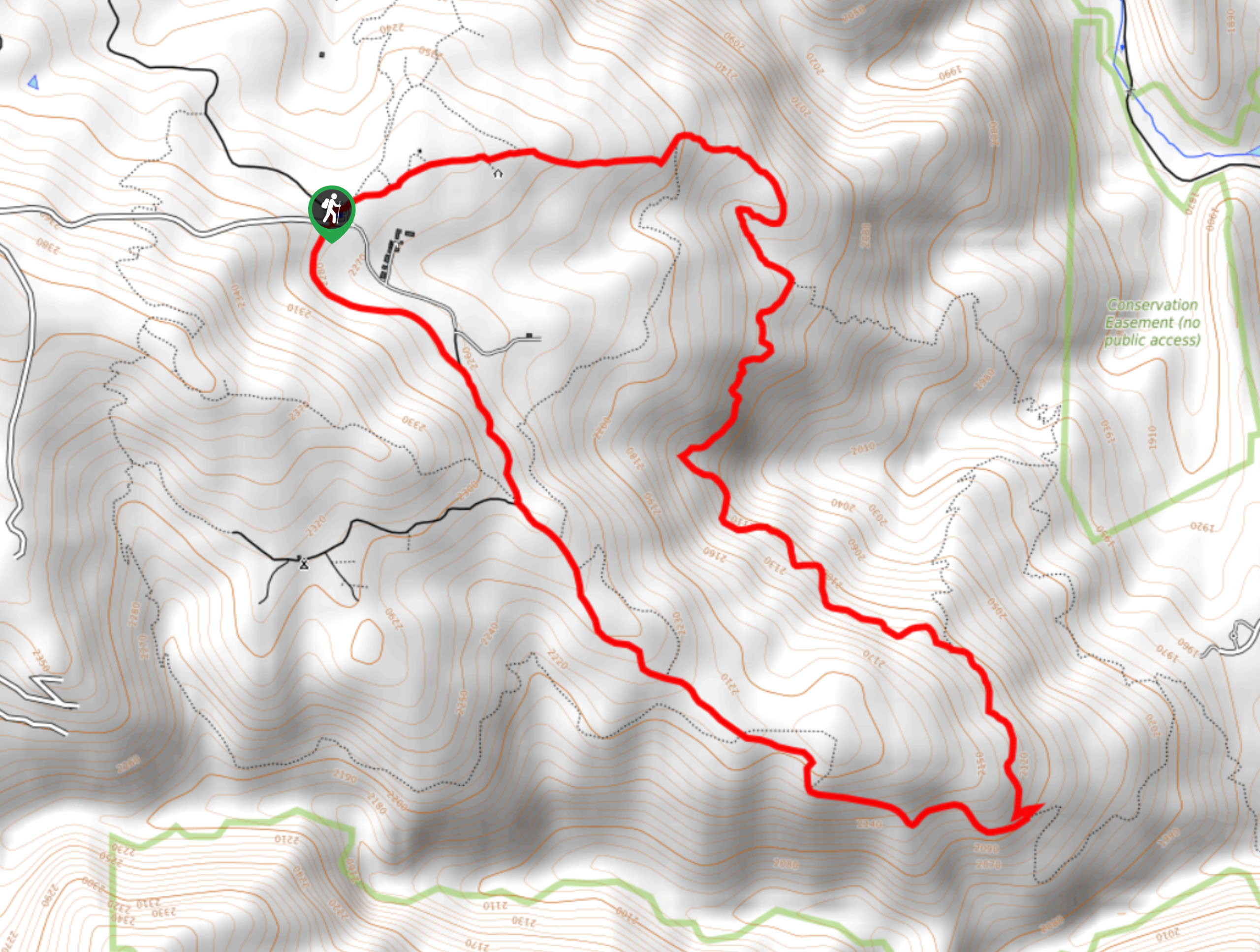
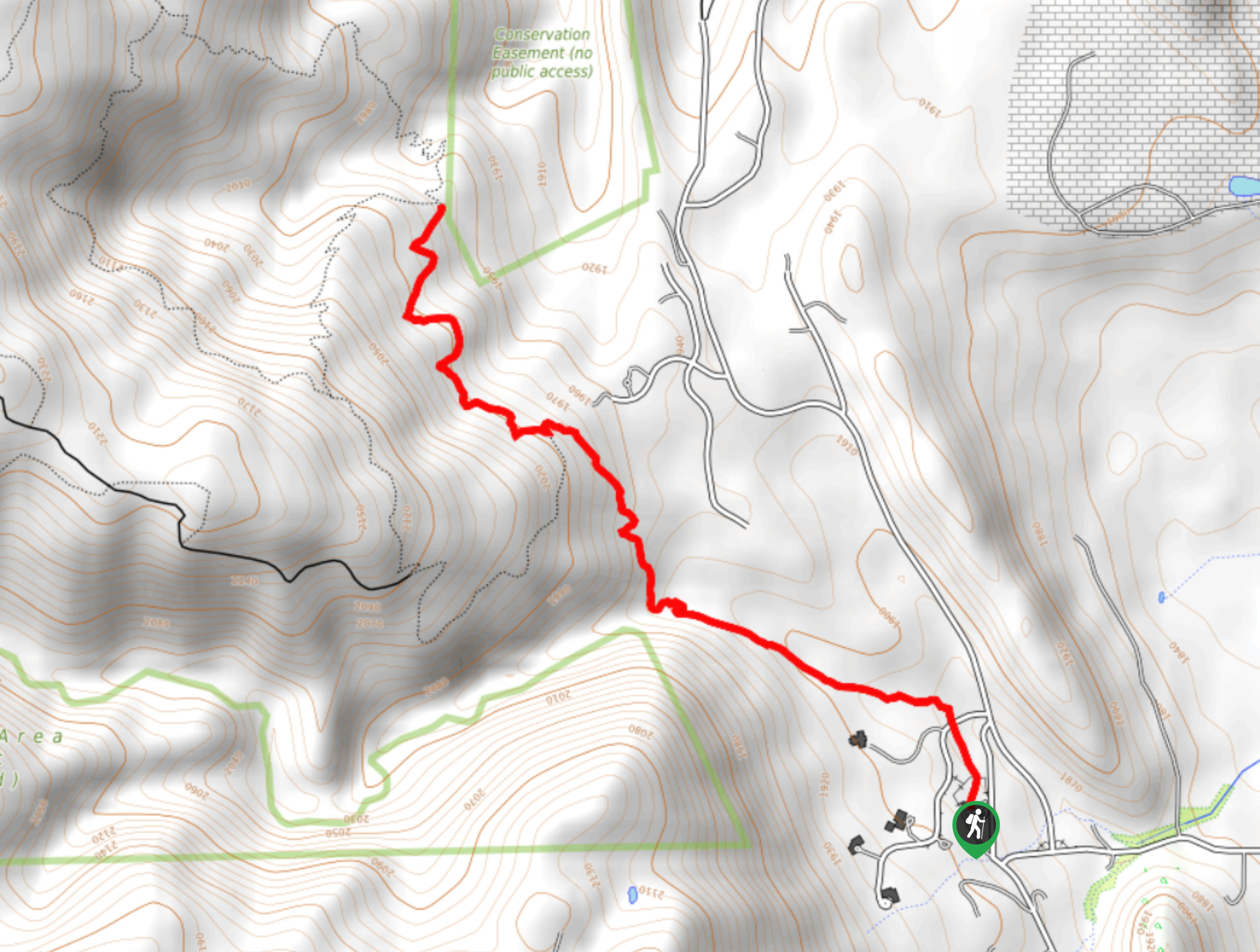
The Longhorn and Shorthorn Hike departs from the trailhead off Belcher Hill Road.

About
| Backcountry Campground | No |
| When to do | April-December |
| Pets allowed | Yes - On Leash |
| Family friendly | Older Children only |
| Route Signage | Average |
| Crowd Levels | Moderate |
| Route Type | Circuit |
Longhorn and Shorthorn Hike
Elevation Graph
Weather
Longhorn and Shorthorn Hike Description
Lace up those hiking shoes because we are going on an adventure. The Longhorn and Shorthorn Hike is a scenic route that guides explorers through the diverse terrains that Colorado has to offer. Travel through meadowlands, beneath the coverage of towering pines, and to epic overlooks of the mountainous landscape. Make sure to pack plenty of water and wear layers as the diversity of the wilderness warrants various weather conditions. If you are planning on hiking this trail in the summer months, we suggest heading out in the early morning to avoid the unbearable heat in the meadowlands.
Embark on your adventure along the Longhorn and Shorthorn Hike from the trailhead. From here, track the Upper Longhorn Trail northeast through a luxuriant meadow and beneath the sparse tree coverage. Enjoy the sights of the Front Range foothills and distant views of the city as you walk. Soon you will encounter a junction, keep left. Hike along the path and you will eventually meet another intersection, take the Shorthorn Trail here. Mostly forested, trek the shaded path until the next fork in the road. Here, merge onto the Sawmill Trail.
The Sawmill Trail will guide you northwest, weaving adventurers through the meadows and woodlands. Track this route all the way back to the trailhead, marking the end of your adventure.
Similar hikes to the Longhorn and Shorthorn Hike hike

Singletree and Mayhoffer Trail
The Singletree and Mayhoffer Trail is a scenic adventure that will guide adventurers through the lush meadowlands that reveal sights…

Mount Galbraith via Cedar Gulch Trail
The Mount Galbraith via Cedar Gulch Trail is a charming adventure near Golden, Colorado that reveals the beauty and diversity…
Belcher Hill and Whippletree Trail
The Belcher Hill and Whippletree Trail is an exciting adventure—how could it not be with a name like that? The…
Comments