Horseshoe Loop Trail
View Photos
Horseshoe Loop Trail
Difficulty Rating:
The Horseshoe Loop Trail is a stunning adventure through the Golden Gate Canyon State Park. There is nothing better than a circuit trail because the scenery is new every step of the way. Hike beneath the coverage of towering pines, through aspen groves, and up to a luxuriant meadow where visitors can often spot grazing deer and elk!
Getting there
The Horseshoe Loop Trail departs from the trailhead off Crawford Gulch Road.

About
| Backcountry Campground | Dispersed Backcountry Campsites |
| When to do | Year-round |
| Pets allowed | Yes - On Leash |
| Family friendly | Yes |
| Route Signage | Average |
| Crowd Levels | High |
| Route Type | Circuit |
Horseshoe Loop Trail
Elevation Graph
Weather
Horseshoe Loop Trail Description
The Horseshoe Loop Trail is a must-add to your Denver itinerary. Reconnect with nature and let go of the stressors of the real world as you adventure through the beautiful Colorado wilderness. This path also presents the perfect opportunity to spot wildlife, so keep an eye out! As this route weaves between tree shade and exposed terrain we recommend wearing layers as insurance against changing weather conditions. Note that because this trail is located within the bounds of the Golden Gate Canyon State Park, visitors are required to purchase a day pass which typically costs around $10USD.
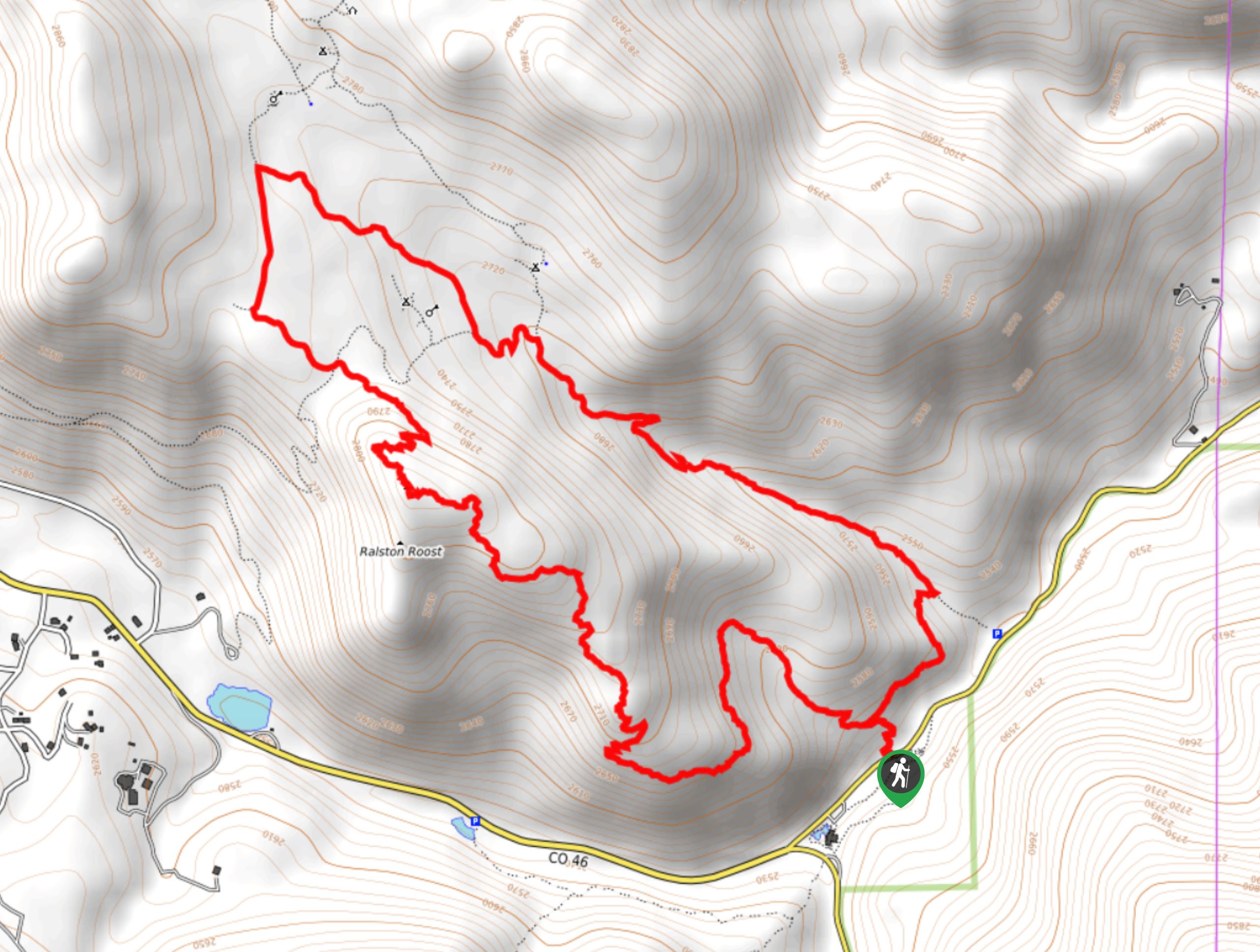
Begin your journey along the Horseshoe Loop Trail from the trailhead off Crawford Gulch Road. You can choose to complete this adventure from either direction, but we prefer to hike this one clockwise. From the trailhead, track the Black Bear Trail beneath the timberline. As you travel along this path, you will be rewarded with expansive views of the Front Range foothills and on a clear day, sights of the snow-capped Front Range peaks. Eventually, you will confront an intersection, stay straight and hike northeast along the Mule Deer Trail. Now passing through the meadows, keep an eye out for deer and elk.
At the next junction, turn right onto the Horseshoe Trail, passing several dispersed campsites. Keep left at the next two intersections, maintaining the same trail. The Horseshoe Trail will guide you southeast down a forested gulch. At the next junction, keep right onto the Black Bear/ Horseshoe Connector Trail, which will deliver you back to the trailhead.
Similar hikes to the Horseshoe Loop Trail hike

Singletree and Mayhoffer Trail
The Singletree and Mayhoffer Trail is a scenic adventure that will guide adventurers through the lush meadowlands that reveal sights…

Mount Galbraith via Cedar Gulch Trail
The Mount Galbraith via Cedar Gulch Trail is a charming adventure near Golden, Colorado that reveals the beauty and diversity…
Belcher Hill and Whippletree Trail
The Belcher Hill and Whippletree Trail is an exciting adventure—how could it not be with a name like that? The…
Comments