
Two Moors Way Section 4: Holne to Hameldown
View Photos
Two Moors Way Section 4: Holne to Hameldown
Difficulty Rating:
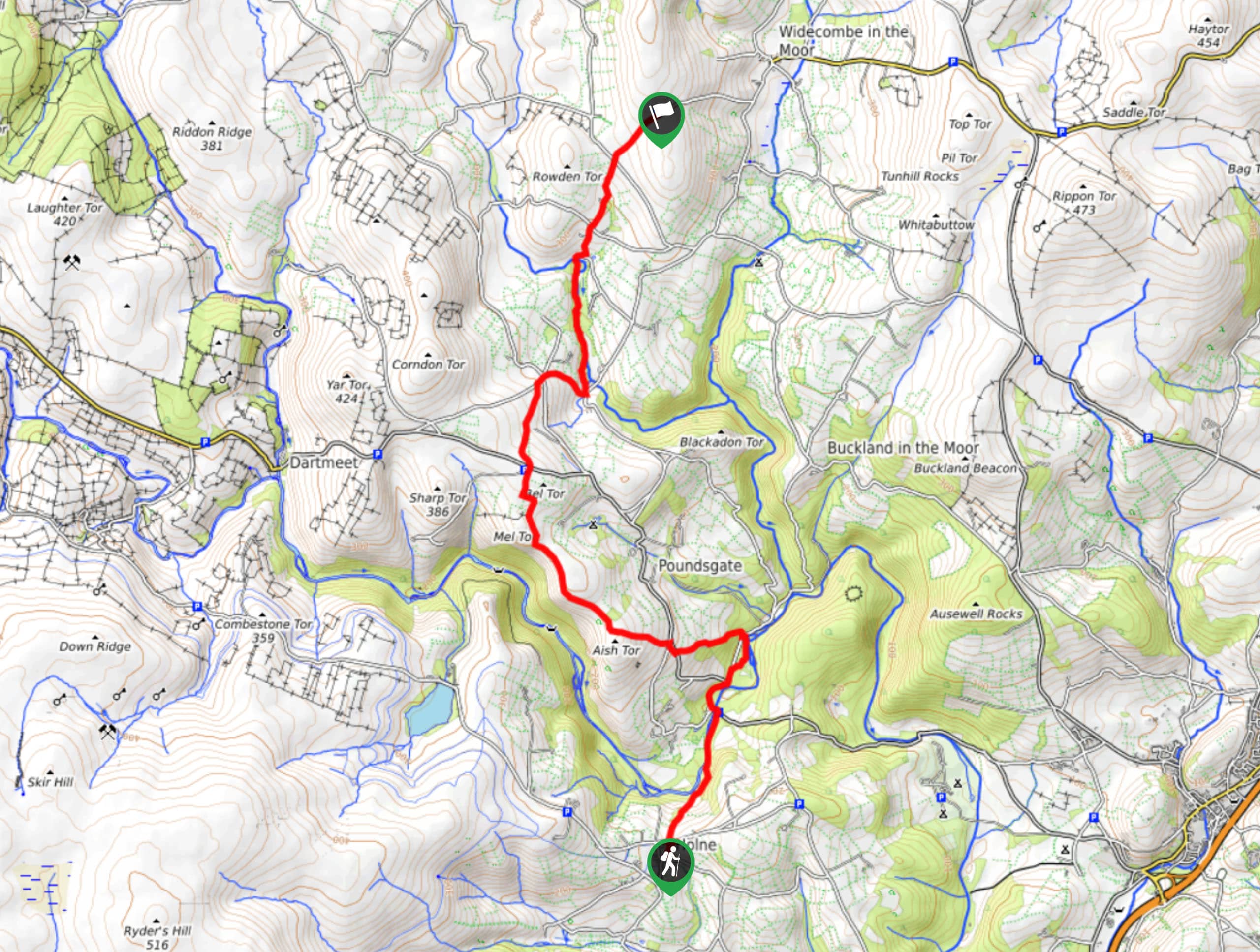
Walking the Two Moors Way Section 4: Holne to Hameldown is only a short snippet of a much longer journey across Dartmoor and Exmoor national parks; however, it offers a good amount of picturesque scenery that can be enjoyed along the way. Along the walk, you will make your way across an undulating stretch of terrain within Dartmoor, travelling along the River Dart and climbing uphill across several tors, before finishing the day off with a stroll along the West Webburn River and a final climb uphill. This is a one-way trail, so make sure to pre-arrange a pick-up at the endpoint of the walk unless you want to double the overall distance.
Getting there
To reach the Two Moors Way Section 4: Holne to Hameldown trailhead from Ashburton, drive southwest on West Street/B3352 for 2.8mi and make a slight left to continue on for 0.5mi. Turn right here and follow the road for 0.8mi before making a left. After 0.1mi, you will arrive at the starting point of the walk.

About
| When to do | March-November |
| Backcountry Campsites | No |
| Pets allowed | Yes - On Leash |
| Family friendly | Older Children only |
| Route Signage | Average |
| Crowd Levels | Moderate |
| Route Type | One Way |
Two Moors Way Section 4: Holne to Hameldown
Elevation Graph
Weather
Two Moors Way Section 4: Holne to Hameldown Description
Whether you are aiming to complete the entire walk through Dartmoor and Exmoor or simply this part of it, the Two Moors Way Section 4: Holne to Hameldown is a beautifully scenic adventure that will expose you to wonderful landscapes and memorable experiences. Setting out from the trailhead in Holne, you will head to the northeast and descend the hillside, working your way along the banks of the River Dart as it cuts through the Devon Countryside. Eventually, you will cross over the river and begin to climb uphill to the northwest, traversing the summits of Leigh Tor and Aish Tor in the process. Here, the trail will bend to the north and offer scenic views overlooking the picturesque expanse of Dart Gorge to the west before heading downhill to the village of Ponsworthy. After a stretch of walking along the West Webburn River, you will turn to the northeast and climb uphill on the final leg of the walk to the car park that marks the terminus.
Similar hikes to the Two Moors Way Section 4: Holne to Hameldown hike

Shipley Bridge and Avon Dam Reservoir Walk
Located in the southern part of Dartmoor National Park, the Shipley Bridge and Avon Dam Reservoir Walk is a lovely…

The Sherlock Holmes Track
The Sherlock Holmes Track is a fun adventure in the southeast corner of Dartmoor National Park that will take you…

Ryder’s Hill via Sandy Way Trail
The Ryder’s Hill via Sandy Way Trail is a beautiful walking route in Dartmoor National Park that will lead you…
Comments