
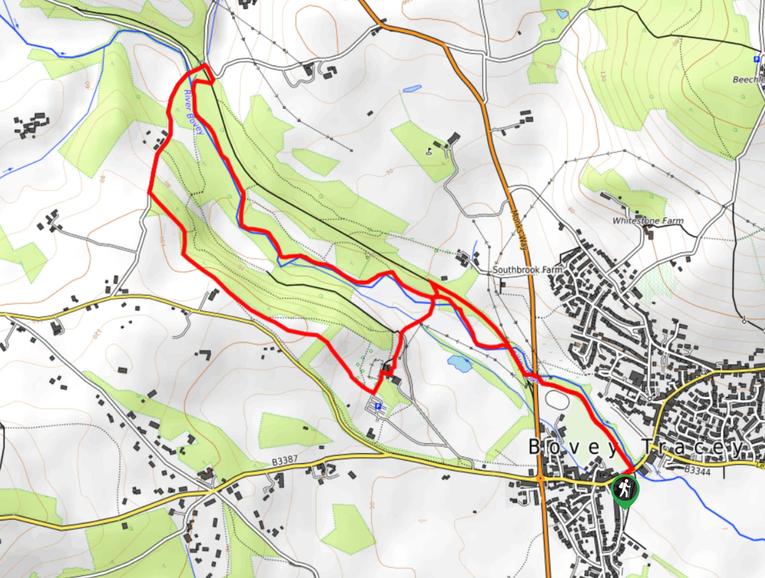
Bovey Tracey and Parke Estate Circular Walk
View Photos
Bovey Tracey and Parke Estate Circular Walk
Difficulty Rating:
The Bovey Tracey and Parke Estate Circular Walk is a fantastic excursion that will lead you through a good variety of terrain that borders the town of Bovey Tracey on the eastern edge of Dartmoor National Park. While out walking the trail, you will navigate through peaceful woodlands that run alongside the River Bovey before climbing uphill to loop back through the fields and meadows of the Parke Estate. This is a great route if you want a fairly relaxed walk that features a number of different terrain types.
Getting there
To reach the trailhead for the Bovey Tracey and Parke Estate Circular Walk from Chudleigh Knighton, head west on The Chapelry/B3344 for 2.1mi and turn left onto Bovey Bridge/Fore Street. After 500ft, turn left to enter the car park.

About
| When to do | Year-Round |
| Backcountry Campsites | No |
| Pets allowed | Yes - On Leash |
| Family friendly | Yes |
| Route Signage | Average |
| Crowd Levels | High |
| Route Type | Lollipop |
Bovey Tracey and Parke Estate Circular Walk
Elevation Graph
Weather
Bovey Tracey and Parke Estate Circular Walk Description
Walking the Bovey Tracey and Parke Estate Circular Trail is a laid back experience on the eastern edge of Dartmoor National Park, although it does have a variety of terrain and one long uphill climb near the midpoint of the walk. Be sure to wear comfortable walking shoes for this adventure. Additionally, this trail sees a high amount of foot traffic, particularly with dog walkers, so try to arrive early if your aim is to have a bit of peace and quiet in the serene forest setting.
Even though it may be busy, this walking route is a great way to reconnect with nature and explore the beautiful landscapes that can be found in Devon County. Setting out from the town of Bovey Tracey, you will make your way to the northwest along the winding banks of the River Bovey and pass through a peaceful stretch of woodland terrain before climbing uphill to the southwest. From here, you will make your way across the picturesque meadows and fields of the Parke Estate before descending the hillside for the final leg of the journey along the river back into town.
Similar hikes to the Bovey Tracey and Parke Estate Circular Walk hike

Shipley Bridge and Avon Dam Reservoir Walk
Located in the southern part of Dartmoor National Park, the Shipley Bridge and Avon Dam Reservoir Walk is a lovely…

The Sherlock Holmes Track
The Sherlock Holmes Track is a fun adventure in the southeast corner of Dartmoor National Park that will take you…

Ryder’s Hill via Sandy Way Trail
The Ryder’s Hill via Sandy Way Trail is a beautiful walking route in Dartmoor National Park that will lead you…
Comments