White Mounth Munros Walk
View Photos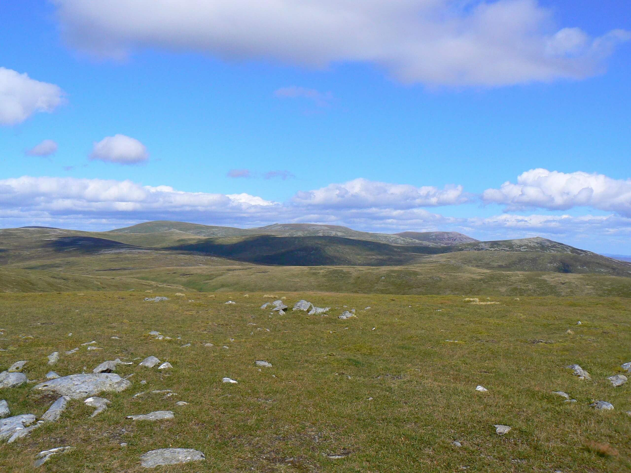
White Mounth Munros Walk
Difficulty Rating:
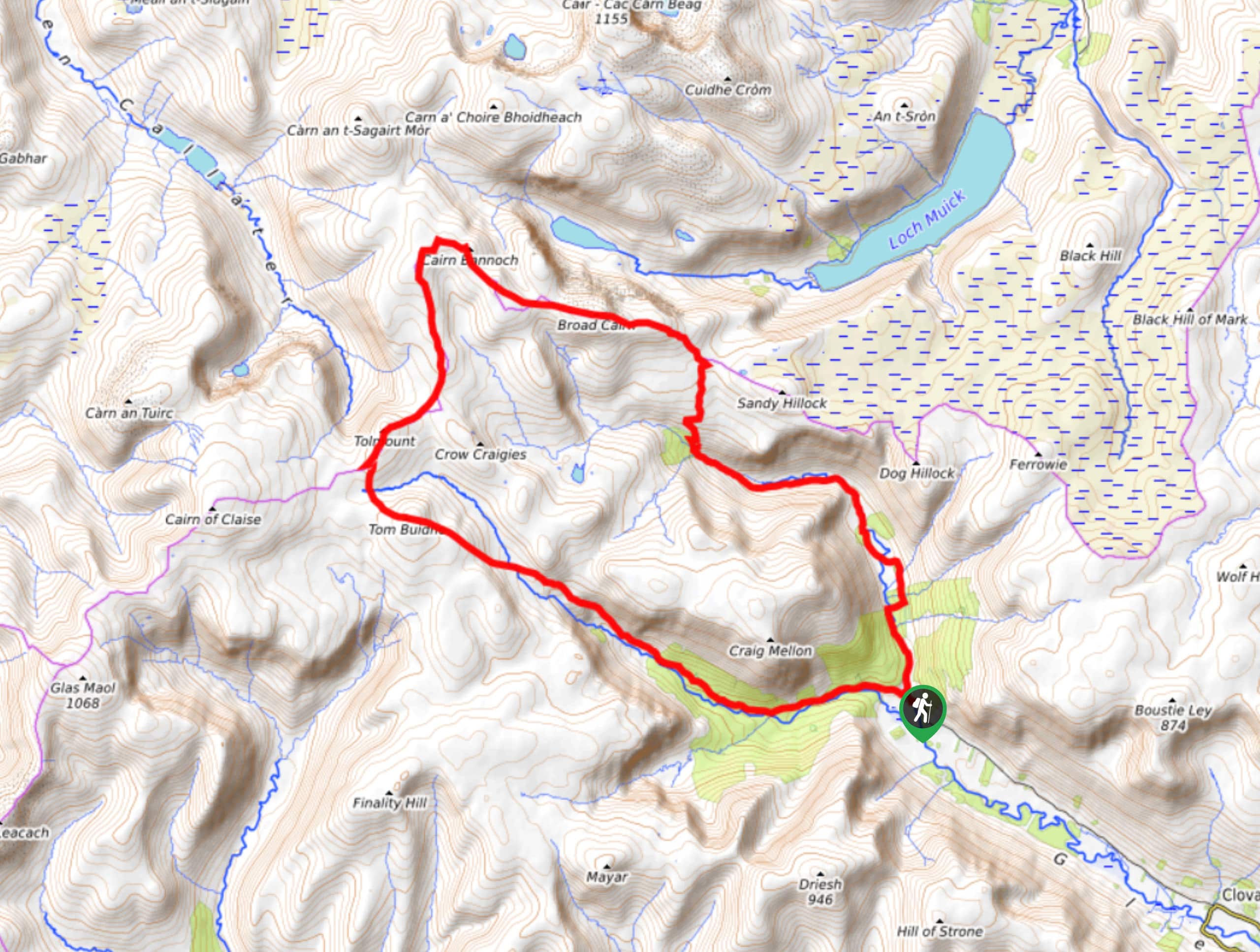
Just shy of 18.6mi long, the White Mounth Munros Walk isn’t for the faint of heart. This extensive 18.0mi hillwalk invites you to tackle the summit of 5 Scottish Munros, including Lochnagar (3789ft), Carn a' Choire Bhoidheach (3642ft), Carn an t-Sagairt Mor (3435ft), Cairn Bannoch(3320ft), and finally Broad Cairn (3274ft). And with a maximum ascent of 4029ft, you’ll no doubt have the opportunity to take in some of the most phenomenal views in the Cairngorms National Park. While the 9 to 11 hour walk can certainly be completed in one go, many choose to Wild Camp for a night or two along the route, breaking the lengthy voyage into shorter sections.
Getting there
To get to the White Mounth Munros Walk from nearby Ballater, head southeast on Hawthorn Cres toward Hawthorn Pl/Inchgeal Gardens. Then, turn right onto Hawthorn Pl/Inchgeal Gardens and continue to follow Hawthorn Pl for 0.1mi. Next, turn left onto Bridge St/A93 and continue 0.2mi before turning right onto B975. After 0.6mi, turn left and continue for 7.7mi to reach the Spittal of Glen Muick Car Park where the walk begins.

About
| Backcountry Campground | Wild Camping |
| When to do | Year-round access |
| Pets allowed | Yes |
| Family friendly | No |
| Route Signage | Average |
| Crowd Levels | Moderate |
| Route Type | Lollipop |
White Mounth Munros Walk
Elevation Graph
Weather
White Mounth Munros Trail Description
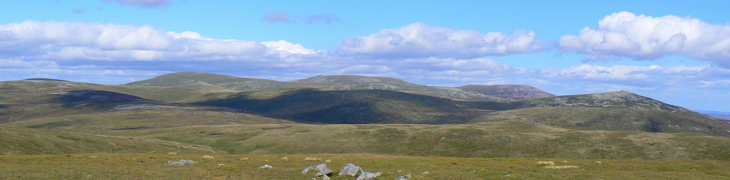
The White Mounth Munros Walk invites you to take in the highlights of the White Mounth plateau, including the phenomenally fine summit of Lochnagar (3789ft). The views are endless and the feeling of one’s smallness when exploring these Munros is guaranteed to make an impact. Before you venture out, it’s important to take note of Stalking information pertaining to this area. Call 01339 755532 and listen to the recorded message.
The White Mounth Munros Walk begins from the car park at the end of the public road that leads up Glen Muick. It’s a good idea to arrive early for this walk, as the car park is busy on weekends and at times full, rendering the access road closed. In this case, find an alternative parking spot and then continue to the Spittal of Glen Muick Car Park to begin the walk.
From the car park, set out along the track towards the Spittal of Glen Muick. Soon after passing the visitors centre you’ll spot your first opponent up ahead—mighty Lochnagar. Head up towards the peak via the track that leads to the right, setting out across the floor of the glen and later crossing the River Muick via a bridge. A path soon invites you to enter the woods and a little further on, join the track that unfolds along a stream. Up ahead you’ll then join the clear path that paves the way to Lochnagar, first up towards the bealach and then further up to the summit. Enjoy the views as you climb the section of slope known as “the ladder” to join a level plateau. Finally at the summit, drink in the views that include Deeside and the impressive Cairngorms massif.
Next after descending back down to the Cac Càrn Mòr, you’ll pick up the path that leads southwest across the expansive plateau. A little further on, you’ll take on The Stuic’s rocky prow, from where you’ll embark on a short detour south to reach the summit of Càrn a’Choire Bhòidheach.
Then, after heading northwest to join the old Stalker’s Path, you’ll then cross the Allt an Da Chraobh Bheath and spot Càrn an t-Sagairt Beag rising dome-shaped to the north. From Càrn an t-Sagairt Beag you’ll continue on the Stalker’s Path before heading up the path that unfolds northwest as you press on to summit number three, Càrn an t-Sagairt Mòr.
After enjoying the insurmountable views, proceed with your descent heading southeast from the cairn down to the bealach. If weather permits, you’ll spot your forth munro, Cairn Bannoch. Following the fourth summit, you’ll continue southeast, passing Carin of Gowal to join the path that leads to the fifth, triumphant peak, Broad Cairn.
From the summit of Broad Cairn, descend the rugged boulder field that makes way for a track leading across the plateau. You’ll find yourself curving southeast while enjoying views of the still, glass-like surface of Loch Muick below. Once the end of the plateau is reached, continue on the zig-zagging track that brings you further down still. Head across the bridge above the Black Burn and follow the track above Loch Muick. At the foot of the loch you’ll pass a boathouse just a short distance away, then proceed straight on the track that will eventually lead back to the Spittal of Glenmuick, where the walk began.
Similar hikes to the White Mounth Munros Walk hike

Glen Banvie Trail and Blair Castle Walk
The Glen Banvie Trail and Blair Castle Walk is a great adventure in Cairngorms National Park that takes in the…

Beinn Udlamain Munro and Sgairneach Mhòr Walk
The Beinn Udlamain Munro and Sgairneach Mhòr Walk is a rugged and exciting journey in Cairngorms National Park that will…
Cairn of Gowal Loop
The Cairn of Gowal Loop is a rough and rugged excursion in Cairngorms National Park that will take you over…
Comments