
Cairn of Gowal Loop
View Photos
Cairn of Gowal Loop
Difficulty Rating:
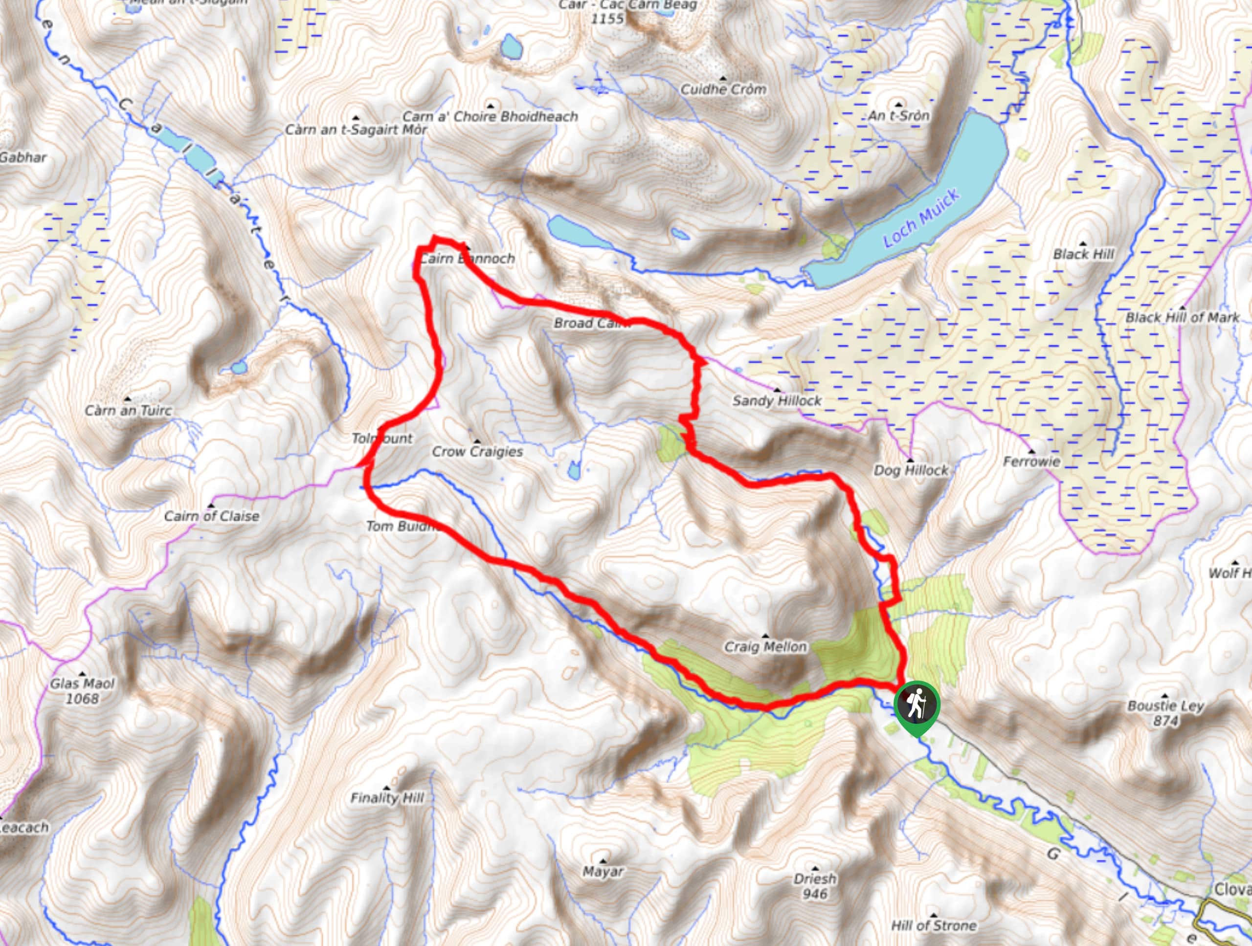
The Cairn of Gowal Loop is a rough and rugged excursion in Cairngorms National Park that will take you over a number of peaks for breathtaking views of the surrounding landscape. While out walking the trail, you will climb uphill through a glen along the River South Esk, before traversing a series of peaks overlooking Loch Muick and Dubh Loch. This is no doubt a challenging adventure, but the stunning mountain scenery and feeling of accomplishment will certainly be worth the effort.
Getting there
The trailhead for the Cairn of Gowal Loop can be found at the Glendoll car park, located 3.4mi northwest of Clova.

About
| Backcountry Campground | No |
| When to do | April-September |
| Pets allowed | Yes - On Leash |
| Family friendly | No |
| Route Signage | Poor |
| Crowd Levels | Low |
| Route Type | Circuit |
Cairn of Gowal Loop
Elevation Graph
Weather
Cairn of Gowal Loop Trail Description
While there are certainly shorter and easier walking routes in Cairngorms National Park, you will be hard-pressed to find a more scenic adventure than the Cairn of Gowal Loop. Featuring a lengthy overall distance, rugged mountain terrain, and views that sweep across the park, this route will certainly make for an action-packed day on the trails.
Setting out from the car park, you will make your way through the glen to the north, following along the banks of the River South Esk as it snakes through the valley and leads you uphill to the northwest. Here, you will continue further uphill to traverse the summits of Broad Cairn, Cairn of Gowal, and Cairn Bannoch, all while taking in the beautifully scenic views overlooking Loch Muick and Dubh Loch.
Reaching the northernmost point of the route, the trail will bend to the south across Fafernie, traversing the rugged mountain landscape to visit the Munros of Tolmount and Tom Buidhe. From the summit of this last hill, you will make your way into the glen to the southeast where you will meet the banks of White Water. Following the edge of the river, you will pass through the serene expanse of Glendoll Forest and eventually arrive back at the car park where you began your walk.
Similar hikes to the Cairn of Gowal Loop hike

Glen Banvie Trail and Blair Castle Walk
The Glen Banvie Trail and Blair Castle Walk is a great adventure in Cairngorms National Park that takes in the…

Beinn Udlamain Munro and Sgairneach Mhòr Walk
The Beinn Udlamain Munro and Sgairneach Mhòr Walk is a rugged and exciting journey in Cairngorms National Park that will…

Loch an Eilein, Loch Gamhna, Old Logging Way Loop
The Loch an Eilein, Loch Gamhna, Old Logging Way Loop is a wonderful walking trail in Cairngorms National Park that…
Comments