Cairn Toul Walk
View Photos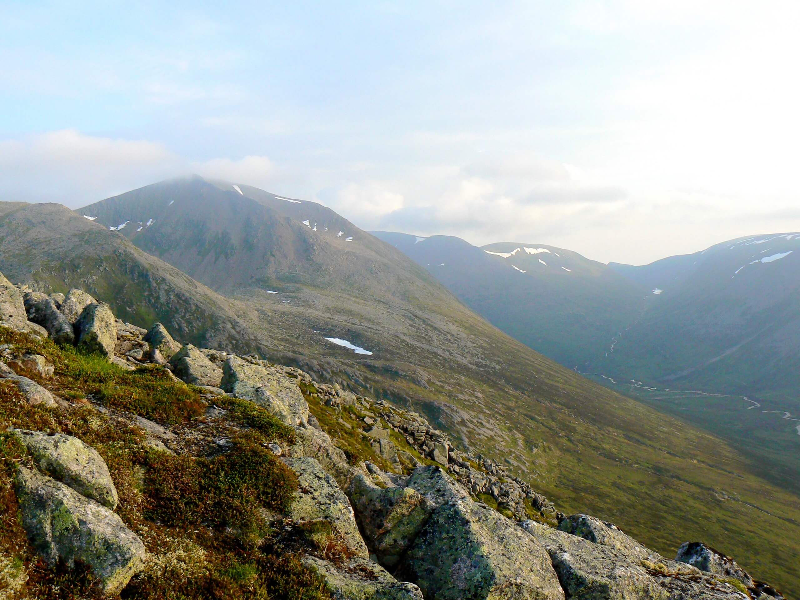
Cairn Toul Walk
Difficulty Rating:
Walk 22.2mi over 2 days from Cairn Toul to Braeriach on the magnificent Cairn Toul Walk. Experience an incredibly remote part of Scotland’s expansive Cairngorms and revel in the views afforded by a total ascent of 5971ft. The option to complete the route in a single day may appeal to extremely experienced hillwalkers, however, we recommend enjoying some wild camping along the way and enjoying this route over two remarkable days.
Getting there
To get to the Cairn Toul Walk from Aviemore follow Dalnabay and Dalfaber Dr to Grampian Rd/B9152 and continue 0.9mi. Then, follow Grampian Rd/B9152 and B970 for 3.0mi and continue straight for another 5.9mi to reach the Sugarbowl Car Park where the walk begins.

About
| Backcountry Campground | Wild Camping |
| When to do | Year-round access |
| Pets allowed | Yes |
| Family friendly | No |
| Route Signage | Average |
| Crowd Levels | Low |
| Route Type | Lollipop |
Cairn Toul Walk
Elevation Graph
Weather
Cairn Toul Walk Description
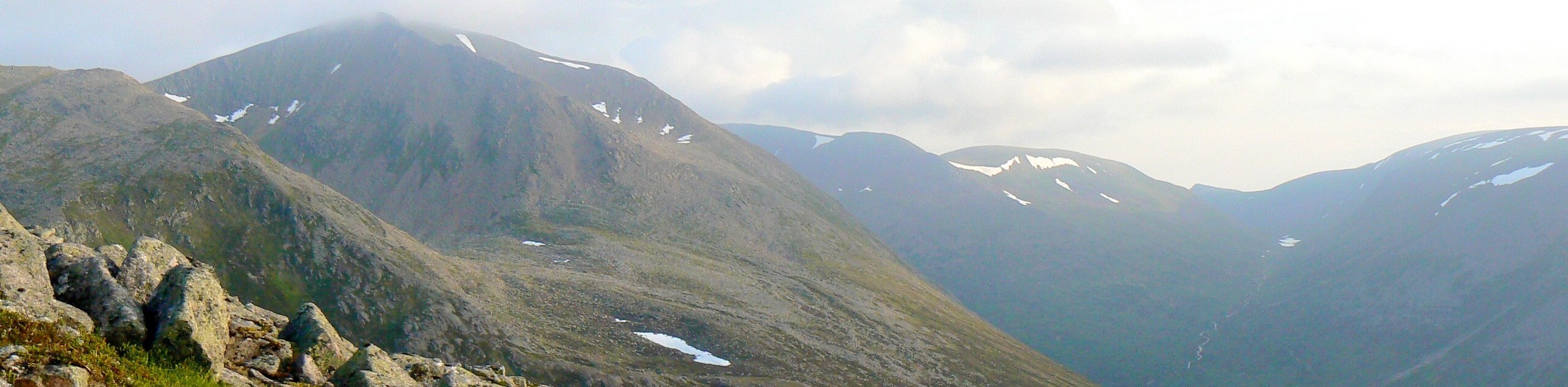
The Cairn Toul Walk invites hillwalkers to set out into a remote part of the Cairngorms on a thrilling two-day adventure. Rocky tundra paves much of the way and care should be taken when crossing the many boulder fields. Much of the route unfolds nearby cliff edges with extensive drops, so extreme caution should be taken as well as taking weather conditions into account.
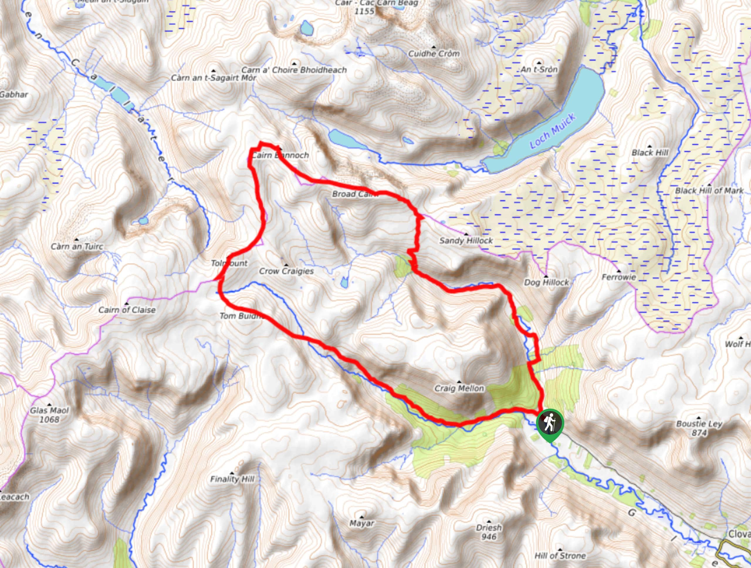
From the Sugarbowl Car Park, head across the road and pick up the path that descends to a footbridge above the Allt Mòr. After crossing, veer right as you head uphill and then left to join a paved road that leads you onwards. Up ahead you’ll reach a small pass known as Chalamain Gap, where you’ll squeeze through the obvious gap between the boulders.
Entering the next section of the walk, you’ll find yourself heading up the glen, flanked by the walls of a deep trench created by Lairig Ghru. Having reached Scotland’s most famous hill pass, you’ll make your way to the top of the pass where you’ll witness unparalleled views of Cairn Toul as well as the Devil’s point.
Continue, passing the Pools of Dee and later across the foothills of the magnificent Ben Macdui. Just under 2.5mi onwards beyond the pools, you’ll reach the Clach nan Taillear. Press on to cross the River Dee up ahead via the bridge and spot the Corrour bothy. Cozy down in the open shelter here or pick a grassy spot nearby for some R&R before continuing the second part of the walk after a good night’s rest beneath the stars.
Rise and shine ready to take on the remainder of the trail. From the bothy, you’ll spot Devil’s point rising formidably in the distance. Pick up the path that rises up near the Allt a ‘Choire Odhair, ushering you into the high corrie. Zig-zag your way up the headwall to reach the bealach. Ascend the Devil’s point before returning to the bealach to embark on the climb to the summit of Coire an t-Saighdeir.
Trace the rim of the corrie which sets you up for the momentous ascent of Cairn Toul. Upon reaching the summit of Cairn Toul, congratulate yourself on successfully climbing Britain’s fourth highest summit—and an extremely bouldery one at that! Your efforts will be well rewarded with views over Coire an Lochain, and Braeriach rising in the distance.
From the summit, head west and continue the route to reach another bealach. Continue across the expansive plateau to Braeriach. From the summit, stand in awe as the Speyside forests unfurl across the beyond as well as Cairn Toul rising triumphantly. Once you’ve drank your fill of phenomenal views, return to the bleach before heading up the Sròn na Lairig ridge.
The path of descent heads northwards along the ride and back down to the Lairig Ghru. Maintain the path heading north and the Lairig path is rejoined, then re-cross the stream and climb towards the Chalamain Gap. Retrace this initial section from the start of the walk to complete the route.
Similar hikes to the Cairn Toul Walk hike

Glen Banvie Trail and Blair Castle Walk
The Glen Banvie Trail and Blair Castle Walk is a great adventure in Cairngorms National Park that takes in the…

Beinn Udlamain Munro and Sgairneach Mhòr Walk
The Beinn Udlamain Munro and Sgairneach Mhòr Walk is a rugged and exciting journey in Cairngorms National Park that will…
Cairn of Gowal Loop
The Cairn of Gowal Loop is a rough and rugged excursion in Cairngorms National Park that will take you over…
Comments