
Walden Ponds Hike
View Photos
Walden Ponds Hike
Difficulty Rating:
The Walden Ponds Hike is a charming nature walk near Boulder’s city centre that is accessible to hikers of almost all skill levels and abilities. Wheelchair and stroller-friendly, this short and sweet nature walk is ideal for a lunch break nature escape and presents the perfect excuse to get the whole gang into the fresh air!
Getting there
The Walden Ponds Hike is accessed via the trailhead and parking lot off N 75th Street.

About
| Backcountry Campground | No |
| When to do | Year-round |
| Pets allowed | Yes - On Leash |
| Family friendly | Yes |
| Route Signage | Average |
| Crowd Levels | Moderate |
| Route Type | Lollipop |
Walden Ponds Hike
Elevation Graph
Weather
Walden Ponds Hike Description
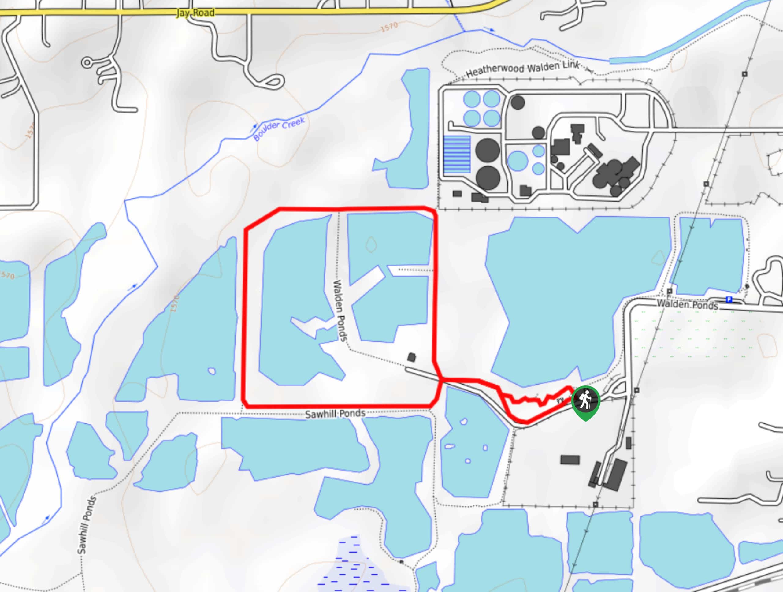
Immerse yourself in nature and keep an eye out for ducks, geese, and herons as you walk along the banks of the ponds. The Walden Ponds Hike is an awesome urban nature walk that exhibits sights of the mountainous landscape that lines the horizon and the Boulder cityscape in the foreground. Located near the water treatment centre, there are dozens of ponds in the area, so feel free to explore. Note that pups are permitted along the gravel trail, but not along the boardwalks. If you have your dogs with you, no worries, you can modify your hike using one of the other routes in the network of trails that litter the area.
Embark on your journey along the Walden Ponds Hike from the trailhead and parking lot. From here, track west along the Walden Ponds Trail. The initial segment of the hike will guide adventurers past the Sawhill Ponds in the south. Follow this path until you encounter an intersection. Here, keep left along the Walden Ponds Trail to hike clockwise. As you walk you will be surrounded by glittering water on either side. In the north, notice the Walden Ponds and, in the west, enjoy sights of the rolling foothills. Soon the path will divert you north, away from the Sawhill Ponds.
Continue hiking the route as it curves east along the ponds and past the water treatment centre. Eventually, the trail will deliver you back to the first intersection. At this point, turn left and retrace your footing along the path back to the trailhead.
Similar hikes to the Walden Ponds Hike hike

Crown Rock Trail
The Crown Rock Trail is a short but sweet nature walk that presents the perfect excuse to get the family…
Chautauqua, Bluebell and Baird Trail
Immerse yourself into nature and get some fresh air along the Chautauqua, Bluebell and Baird Trail. Conveniently located just outside…
Bluebell, Woods Quarry, and Enchanted Mesa Loop
The Bluebell, Woods Quarry and Enchanted Mesa Loop is a charming nature walk in the Boulder Open Space. Conveniently located…
Comments