
Mount Heinen Hike
View Photos
Mount Heinen Hike
Difficulty Rating:
The Mount Heinen Hike is a demanding and dynamic adventure in the Boise National Forest that beckons the exploration of experienced hikers and intrepid spirits. Ascend the precipitous slopes of the highest peak in the ‘Grand Slam’ and you will be rewarded with spellbinding panoramas of the mountainous landscape.
Getting there
The Mount Heinen Hike is accessed from the trailhead off N Fork Boise River Road.

About
| Backcountry Campground | No |
| When to do | April-October |
| Pets allowed | Yes - On Leash |
| Family friendly | No |
| Route Signage | Average |
| Crowd Levels | Moderate |
| Route Type | Out and back |
Mount Heinen Hike
Elevation Graph
Weather
Mount Heinen Hike Description
The Mount Heinen Hike is at the top of most adventurers’ bucket lists when visiting the Boise National, amongst the other ‘Grand Slam’ peaks. While this trek warrants a tireless climb, the payoff negates the sweat. The best tip we can give you is this—trekking poles. No matter your age or ability levels, trekking poles will take some of the pressure off your joints when the time comes to scale back down the mountainside. Additionally, as the terrain is almost entirely exposed, sun protection and a copious amount of water are needed. Our last piece of advice is to keep an eye on the skies, as thunderstorms are common at higher altitudes and are extremely dangerous when exploring the open moorlands.
There is nothing quite like the sense of achievement after tackling a taxing trek—and completing the Mount Heinen Hike offers that sentiment. The consistent climb will exhaust you, we admit it, but the views from atop the peak are simply breathtaking. Above the clouds, you will be granted awe-inspiring panoramas of the Boise Mountains, the rugged Rockies, the Arrowrock Reservoir, and the surrounding cities—so don’t forget your camera! While the stunning overlook is the piece de resistance, the ascent through lush grasslands flowering with Arrowleaf Balasmroot and an array of other vibrant wildflowers is truly enchanting, not to mention the abundance of elk and deer that usually adorn the slopes! Note that several false summits are waiting to trick you, so use the trail GPS to find the peak seamlessly.
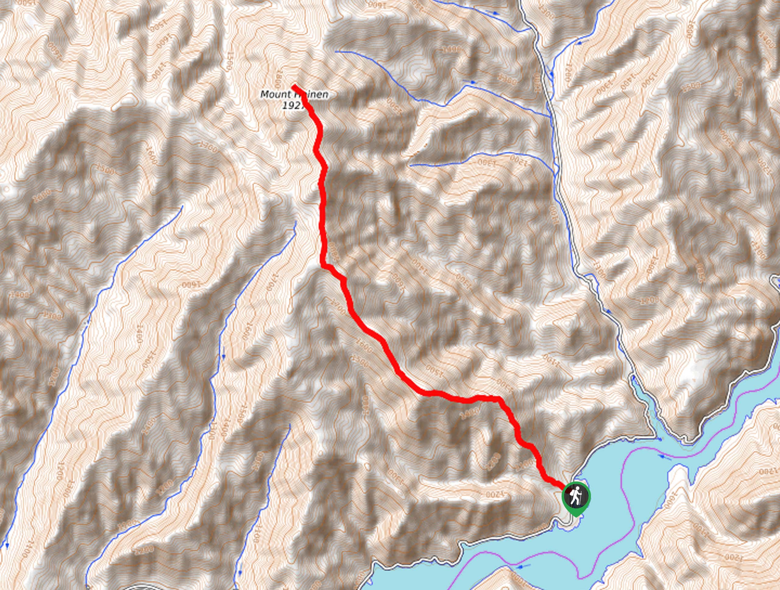
With your trekking poles and plenty of water in tow, your adventure up to the summit of Mount Heinen begins from the trailhead off N Fork Boise River Road. Your first step from the trailhead climbs, giving you a taste of what is to come. From here, you will begin your consistent ascent, wandering into the grasslands occupied with sagebrush and low-lying vegetation. Traveling northwest, the trail is well-worn, mapping the ridges above. As you wander, be sure to take a look behind you and appreciate the scene of the Boise River below. Marvel in the beauty of the wildflowers in the spring and the scene of the changing foliage that covers the foothills in the autumn.
After some hiking, the path will redirect more west, guiding you up to the first false summit. While it is not the destination, the panoramic views aren’t half bad. Take a few minutes here to rest and rehydrate before beginning your final push. Now meandering north, the terrain will become increasingly lush, and there will be the odd pine tree to take refuge under. Soon you will reach the summit of the highest peak in the ‘Grand Slam’. Notice Cervidae Peak and Shaw Mountain in the southwest, the Arrowrock Reservoir below, and Kepros Mountain across the river. Appreciate the grandeur of the Sawtooth Mountains in the northeast and the beauty of the encompassing Boise Mountains. When you are rested and through reveling in the scenery, carefully retrace your footing down the path and back to the trailhead.
Trail Highlights
Mount Heinen
Mount Heinen is a summit in the Boise Mountains that towers above Arrowrock Reservoir. Standing at an elevation of 6336ft, Mount Heinen is the highest summit in the collection of 4 peaks known as the ‘Grand Slam’—the others include Cervidae, Shaw, and Kepros.
Insider Hints
Bring lots and lots of water
There are many false summits that will try to trick you!
Trekking poles are a lifesaver—trust us
Be wary of thunderstorms as you explore the exposed ridges
Use the trail GPS to avoid false summits
Keep an eye out for elk
Similar hikes to the Mount Heinen Hike hike
Station Creek Trail
The Station Creek Trail is a hidden treasure in the Boise National Forest. This lovely path explores shaded pine forests…
Around the Mountain Hike
Enjoy a different perspective of Bogus Basin along the Around the Mountain Hike. What is a bustling ski resort in…

Kepros Mountain Trail
The Kepros Mountain Trail ascends one of Boise’s famed ‘Grand Slam Peaks’. Tempting experienced hikers and ambitious beginners, this demanding…
Comments