
Ute Trail
View Photos
Ute Trail
Difficulty Rating:
The Ute Trail is a scenic summertime adventure along the slopes of one of the Colorado’s favorite ski hills. Climbing up to Richmond Ridge, this trek reveals sweeping vistas of the Elk Mountains and extraordinary views of Aspen Highlands.
Getting there
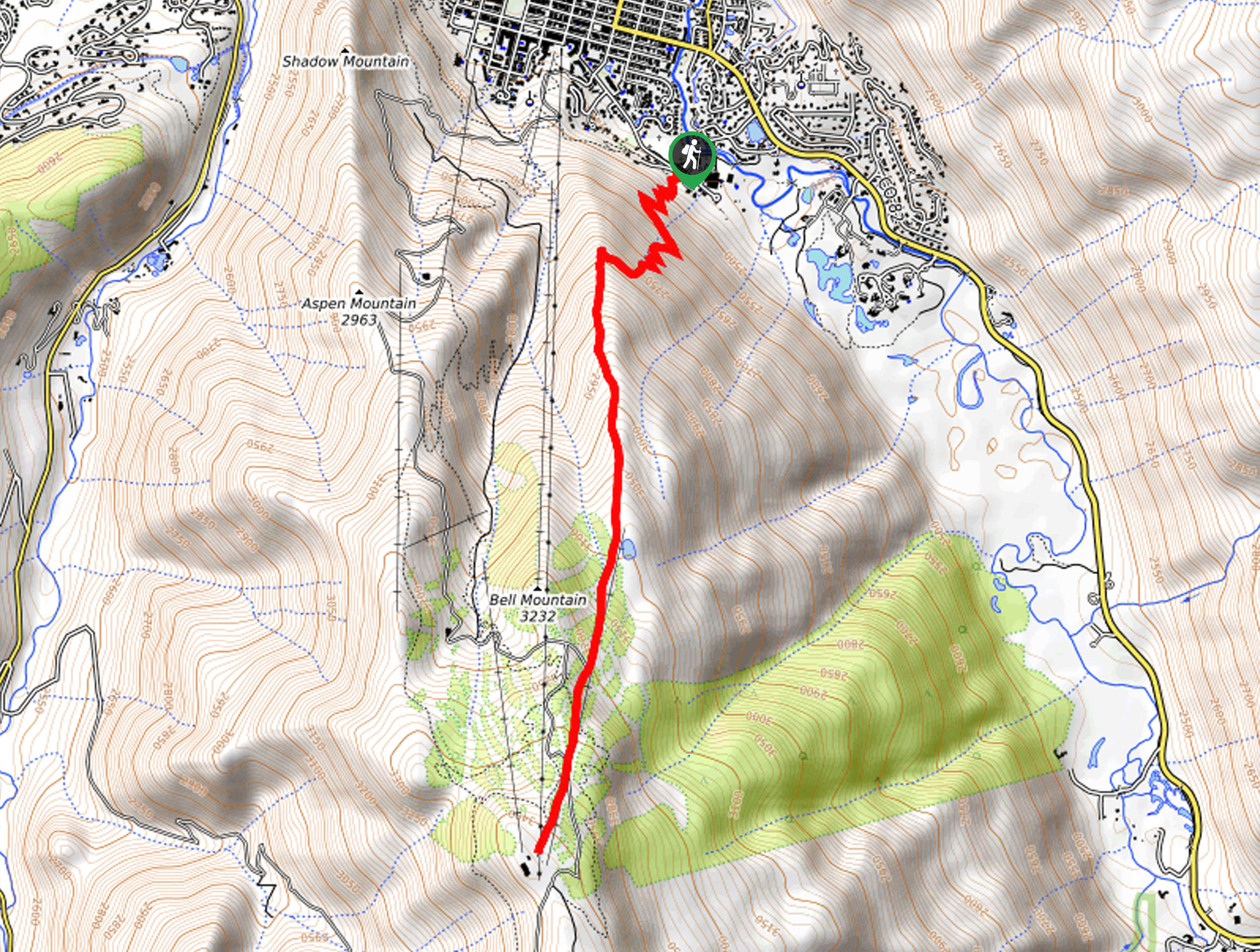
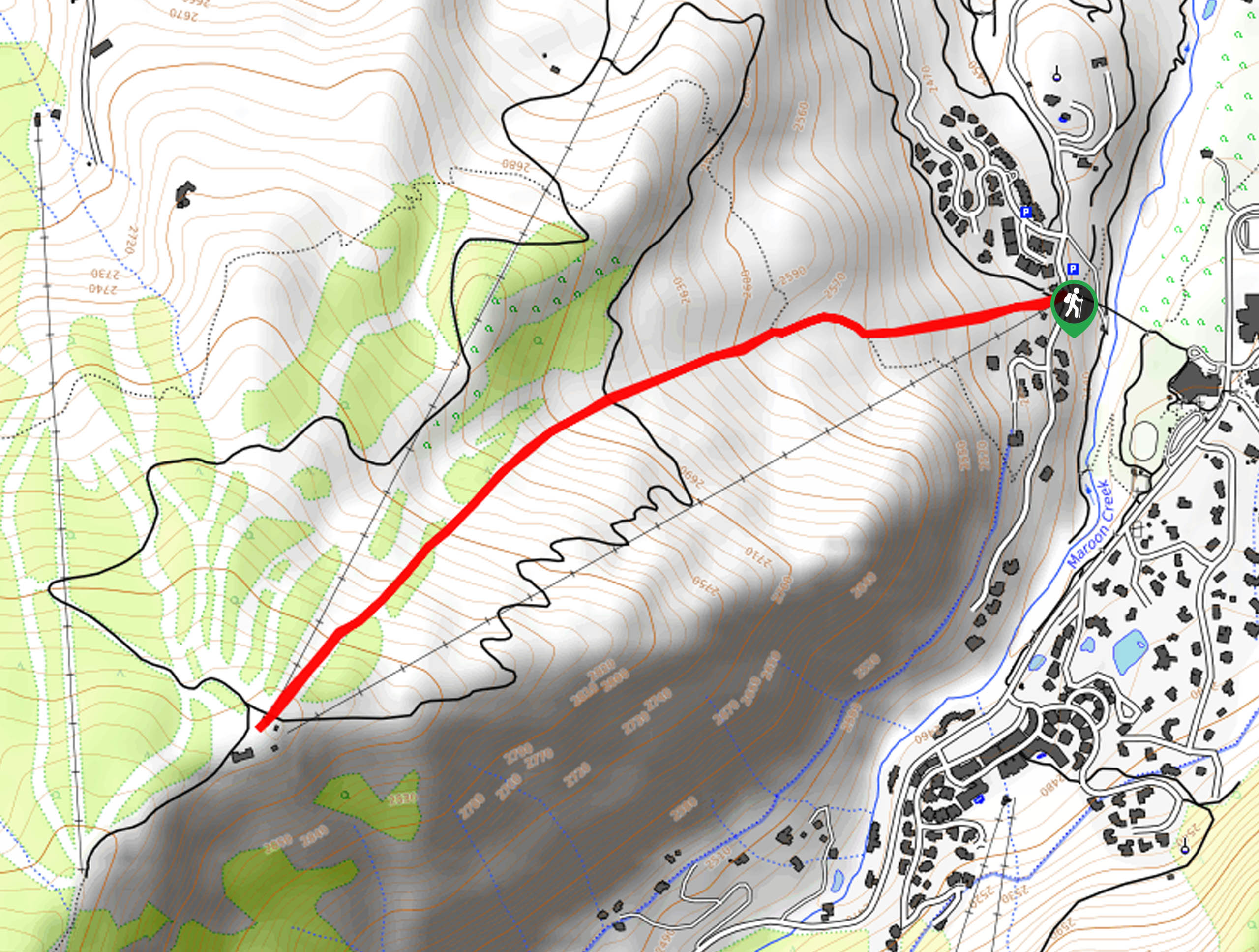
The Ute Trail is accessed via the trailhead off Ute Avenue.

About
| Backcountry Campground | No |
| When to do | May-October |
| Pets allowed | Yes - On Leash |
| Family friendly | No |
| Route Signage | Good |
| Crowd Levels | High |
| Route Type | Out and back |
Ute Trail
Elevation Graph
Weather
Ute Trail Description
Featuring a real wow-factor, the Ute Trail is a challenging, one-of-a-kind adventure. Steep and strenuous, this hike is reserved for experienced hikers as it demands stamina and preparation. Traveling through dense pine forests and up into meadowlands abundant with wildflowers, the scenery from the top is simply breathtaking. Ascending high elevations to epic overlooks, it is important that hikers are acclimatized to the area’s altitude prior to the hike. We also encourage you to bring plenty of water – way more than you anticipate needing. We also suggest layering up your clothing as an insurance against changing conditions, as this trek weaves between exposed meadows and tree shade up to the summit. The Ute Trail is also a popular mountain biking trail, so be mindful of passers-by.
Though taxing, the Ute Hike is well-worth the sweat in our opinion. Experience a different perspective of what would otherwise be a bustling ski and snowboarding destination in the winter months. More tranquil and transformed by lush vegetation, the ski hill attracts outdoor enthusiasts of all sorts in warmer weather. Hike, bike, or horse ride up the vertiginous terrain to awe-inspiring overlooks of Colorado’s dramatic peaks and the city below. The beauty of this technical climb is this: if you are exhausted from the climb to the summit, take the Silver Queen Gondola back down the slopes, saving the stress on your knees! We absolutely love this demanding trek, and once you venture it, you will understand why.
Embark on your journey along the Ute Trail from the trailhead off Ute Avenue in the Aspen Mountain Ski Resort. From here, hikers will be guided up several switchbacks traveling through forested terrain. Enjoy the sweet-smelling evergreens that tower above as you navigate the winding path. Soon, the route will open into a lush meadowland, revealing sights of the mountain looming above and the chairlifts that run parallel to the slopes. Follow the trail south, enjoy the diverse views along the way– including sights of Aspen below!
Weaving between woodlands and meadows, the change of scenery will hopefully distract you from the severity of the incline. Let the stunning landscapes and the anticipation of the vistas from the trail’s end motivate you to continue along your journey. Eventually, you will reach the summit of Bell Mountain— a smaller peak located just to the southeast of Aspen Mountain (Ajax). Once you reach this point you have almost made it to the route’s culmination, yay! Now hiking parallel to Gents Ridge Chairlift, you will finally meet your journey’s end at The Sundeck.
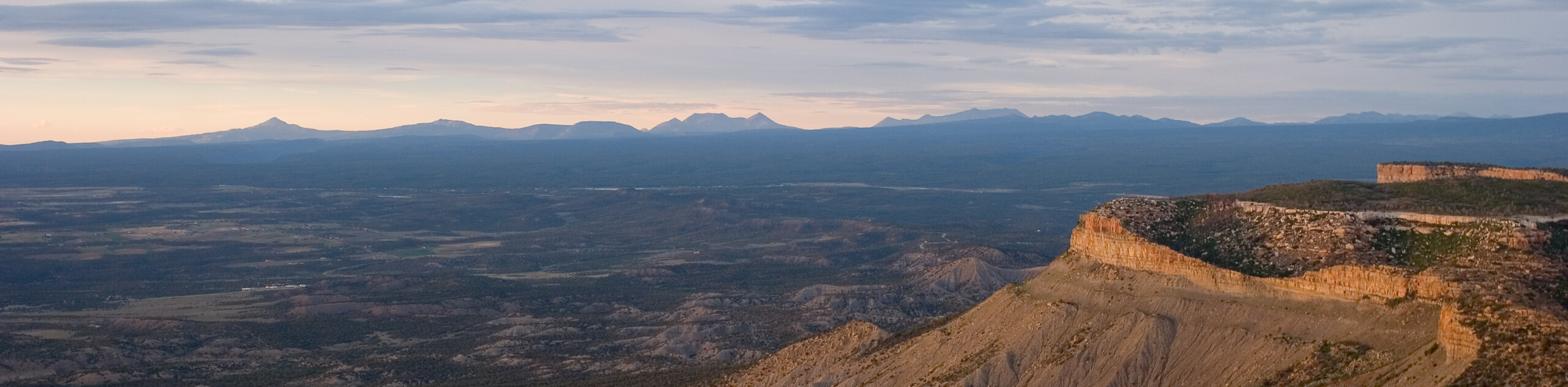
Rest, rehydrate and revel in the expansive alpine panoramas. Notice Aspen Mountain in the northwest, the Aspen Highlands Ski Resort in the west, the Collegiate Peaks in the southeast, and the dozens of other snow-capped summits that stretch for as far as the eye can see. Revel in the grandeur of Colorado’s high country and appreciate the beauty that surrounds you. Explore the mountain top and notice the ski resort’s system of trails and chair lifts that litter the slopes below. If you are seeking an exciting way to get down the mountain, then why not take the Silver Queen Gondola? If you are determined to get your steps in, then simply retrace your footing along the path all the way back to the trailhead, marking the end of your adventure.
Frequently Asked Questions
How long is the Ute Trail in Aspen?
The Ute Trail in Aspen travels about 6.2mi up to the summit of Bell Mountain.
Are dogs permitted on the Ute Trail?
Yes, dogs are permitted on the Ute Trail.
Is the Ute Trail hard?
The answer is subjective, but yes, due to the steepness of the terrain, the Ute Trail in the Aspen Mountain Ski Resort is challenging.
Insider Hints
Pack provisions and have a picnic at the summit overlooking the the stunning mountainous landscape
If the hike up to the peak exhausted you, then take the Silver Queen Gondola back down the mountain!
Charge your camera, the picturesque scenery warrants countless photo-ops
Pack plenty of water, more than you anticipate needing—trust us
Enjoy a well-deserved beer at The Sundeck on top of the mountain
Similar hikes to the Ute Trail hike
New York Creek Trail
The New York Creek Hike is a stunning adventure through Colorado’s high country. Featuring lush woodlands, expansive meadows, and mountain…
Montezuma Basin Trail
The Montezuma Basin Trail is an epic hike that attracts outdoor enthusiasts of all sorts. Hike, bike, or drive the…
Tiehack Hike
Seeking a killer workout? The Tiehack Hike is a butt-burner of a trek in the Buttermilk Ski Resort, a bustling…
Comments