
Long Lake Trail
View Photos
Long Lake Trail
Difficulty Rating:
The Long Lake Trail is a hidden gem in the Wind River Range. Beckoning the exploration of intermediate hikers and families with older children, this adventure will tempt you with an easy way down before demanding a challenging ascent back up to the trailhead. Yielding breathtaking views of the mountains mirrored in the beautiful lake, this trek is hard to beat.
Getting there
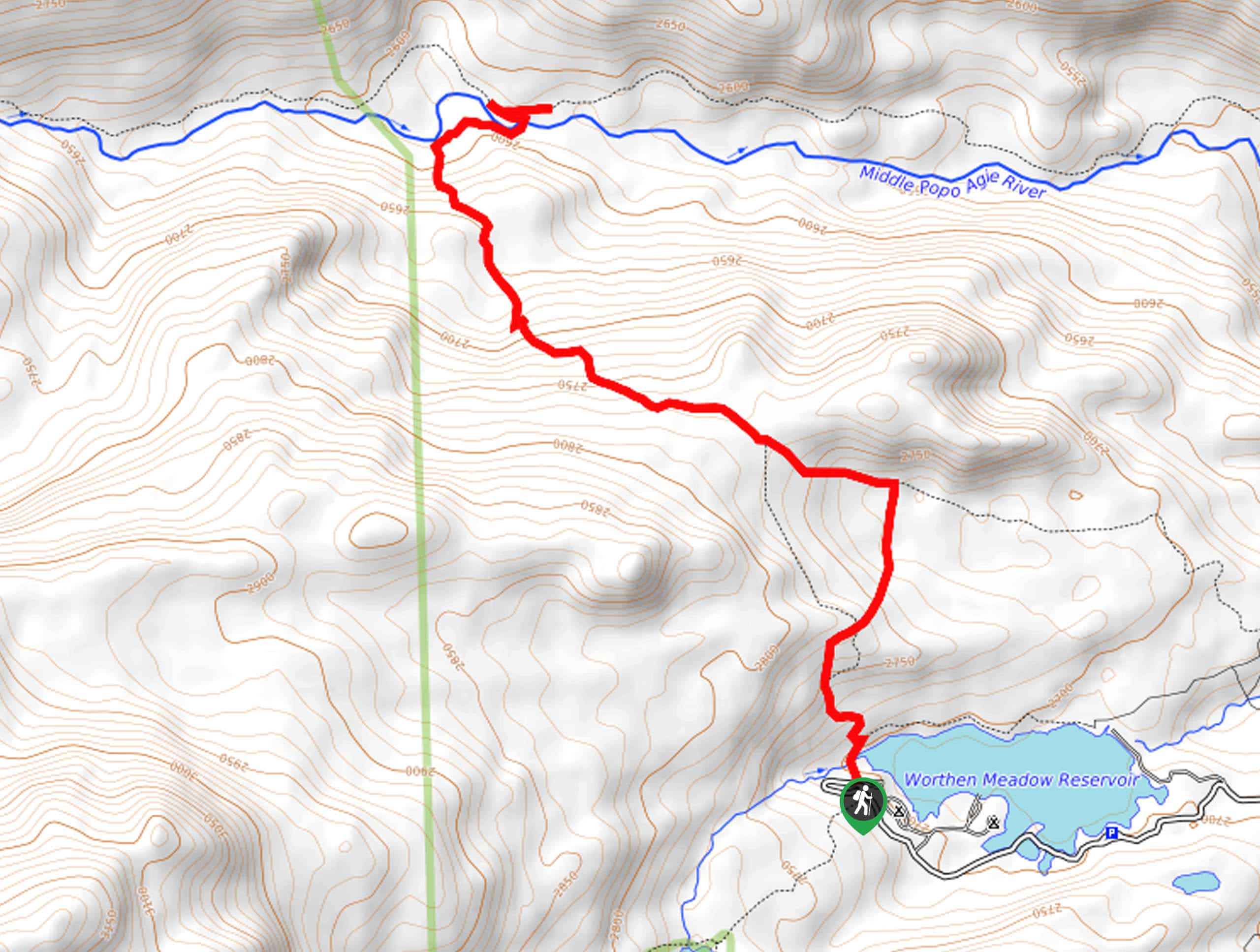
The Long Lake Trail is accessed via the trailhead off Skyline Drive.

About
| Backcountry Campground | Backcountry Camping |
| When to do | May-September |
| Pets allowed | Yes - On Leash |
| Family friendly | Older Children only |
| Route Signage | Good |
| Crowd Levels | Low |
| Route Type | Out and back |
Long Lake Trail
Elevation Graph
Weather
Long Lake Trail Description
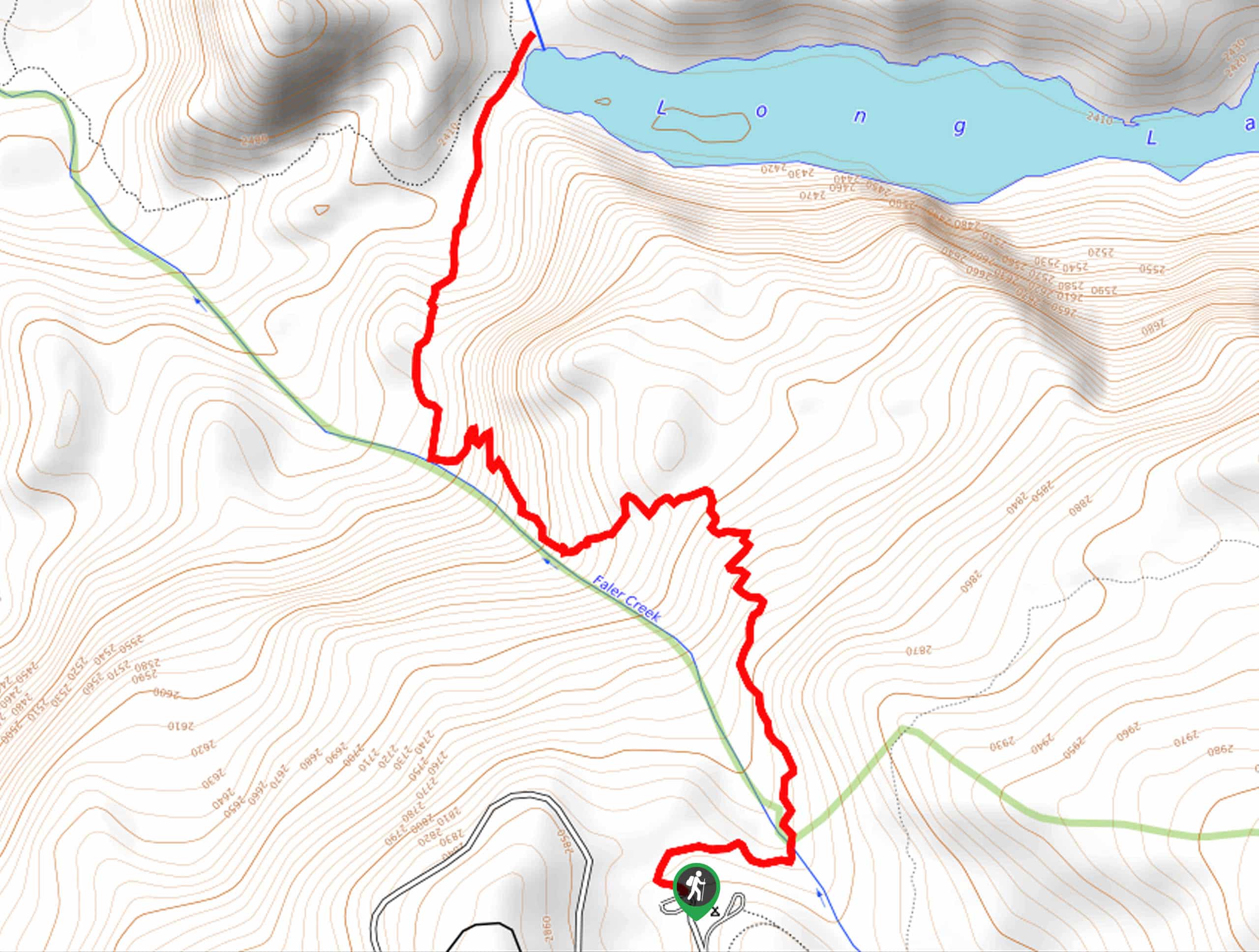
The Long Lake Trail grants striking views of the Wind River Range from the base of the Freemont Creek canyon. Deceiving due to its short length, this trek demands the navigation of steep, rocky terrain, so come prepared to break a sweat—notably on the climb back up! While the terrain is quite vertiginous, the trail is explicitly marked, and there is no scrambling required, though we encourage you to wear a sturdy pair of footwear to mitigate the chances of a rolled ankle! Note that while unlikely, bear encounters are possible, so we suggest at least one person in your party carry a canister of bear spray—just to be safe.
Those seeking a short but heart-pumping hike in the Wind River Range will likely enjoy the Long Lake Hike. Get a great workout in while reveling in the magnificence of the unspoiled wilderness. Compared to most excursions in the area, especially the nearby Seneca Lake Trail, this route sees little traffic. Relish in the tranquility and delight in the sounds of the wind whistling through the mixed-pine woodlands. While not the best place for wildlife viewing, birding and fishing opportunist are abundant! We love this short but scenic expedition amongst the Winds, and we think you will too.
Embark on your adventure along the Long Lake Hike from the trailhead off Skyline Drive. You will find the trailhead at the end of the road, hidden behind the Trail’s End Campground. Setting out from here, the Long Lake Trail will escape into the wilderness, guiding you beneath a lush tree canopy of mixed pines. Gradually descending, the path will soon intersect with Faler Creek before rerouting south. Take your time and be mindful of your knees as you head down towards the lake. Offering peeks of the surrounding mountainscape through the tree breaks, you will catch glimpses of Pine Mountain in the northwest and Guiterrez in the northeast as you wander.
After some hiking, the path will again near Faler Creek, demanding the navigation of switchbacks. Though monotonous, the zigzagging route helps in lessening the intensity of the decline. Beyond this point, the terrain will become increasingly rocky and the tree coverage– thinner. Scenes of the lake below and the bounding bluffs will begin you unfold before your eyes. Soon the path will curve northeast, ultimately delivering you to the shoreline of Long Lake. Marvel in the scene of the long, thin lake mirroring the corridor of mountains that surround the valley, including Photographer’s Point in the east rising above the valley. Admire the beautiful setting, then head back up to the trailhead the way you came, or head west and explore Fremont Lake.
Frequently Asked Questions
How long is the Long Lake Hike?
The Long Lake Trail is a 4.7mi out-and-back hike.
Where is the access to the Long Lake Trail?
The Long Lake Hike is accessed via the trailhead at the end of Skyline Drive.
Insider Hints
Practice No Trace principles
At least one person in your group should carry bear spray
Wear a sturdy pair of footwear, the terrain is rocky and steep
The bugs are relentless, so bring bug spray
Charge your camera, the scenery is picture-perfect
After rainfall the path is slippery, exercise careful footing
Similar hikes to the Long Lake Trail hike
Glacier Trail
The Glacier Trail is a demanding day hike in the Winds that boasts a scenic and secluded experience. Wander through…
Upper Brewers Trail
The charm of a one-way trek is unrivaled. Enjoy new scenery every step of the way as you hike the…
Sheep Bridge Trail
The Sheep Bridge Trail checks all the boxes—short, scenic, and secluded. What more could you ask for? Mountain views? It…
Comments