
The Smith and Morehouse Reservoir Trail
View Photos
The Smith and Morehouse Reservoir Trail
Difficulty Rating:
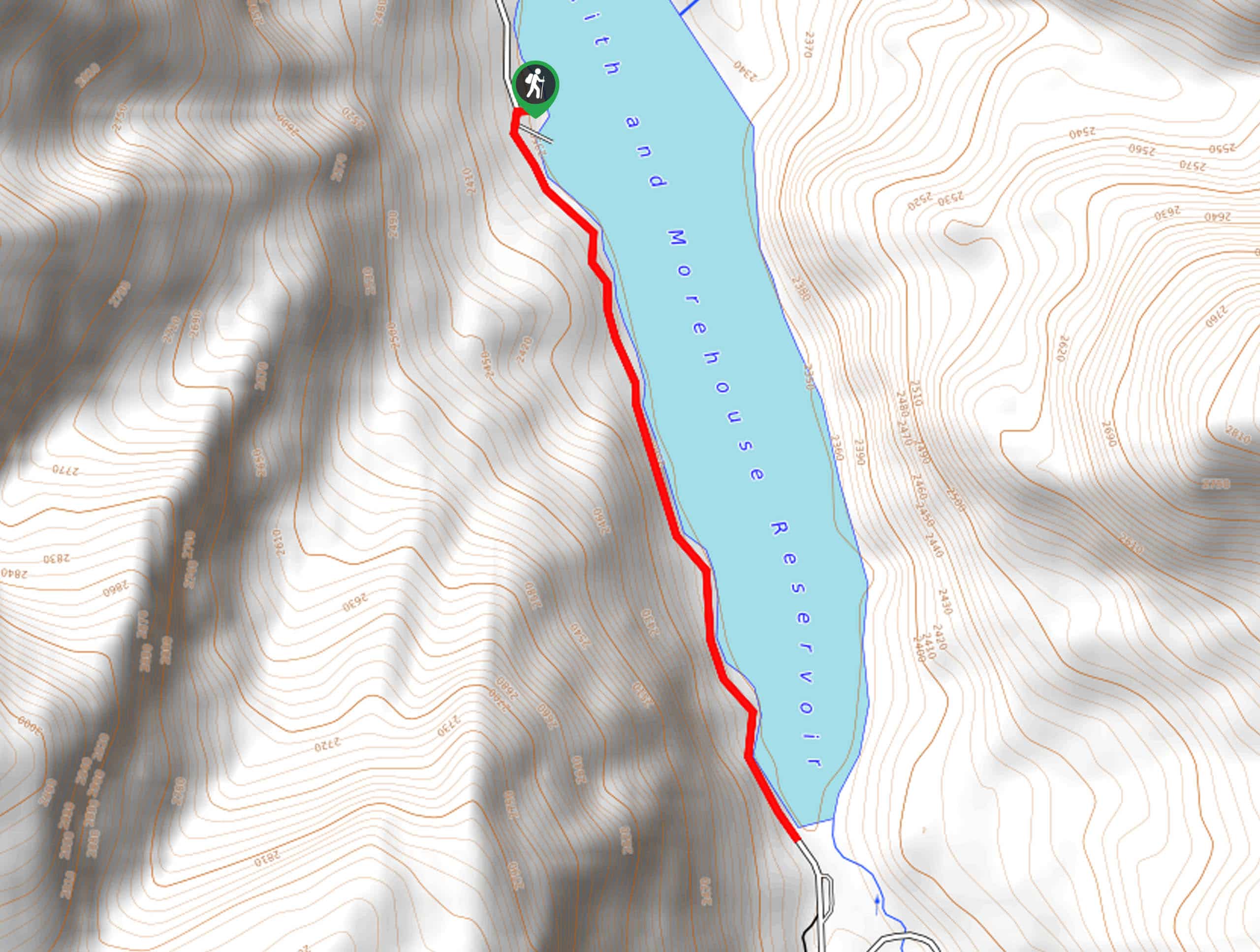
The Smith and Morehouse Reservoir Trail is a short hike along a makeshift path on the western shore of the Smith and Morehouse Reservoir. This trail is family-friendly and a great hike for kids of all ages. Dogs are welcome to join you on the Smith and Morehouse Reservoir Trail, but must be kept on a leash at all times.
Getting there
From Oakley, Utah, follow Weber Canyon Road east for 11.7mi then take a right onto Smith and Morehouse Road. Follow Smith and Morehouse Road south to the Ledgefork Campground. The Smith and Morehouse Reservoir Trail begins here.

About
| Backcountry Campground | Smith and Morehouse Campground, Ledgefork Campground |
| When to do | July to October |
| Pets allowed | Yes - On Leash |
| Family friendly | Yes |
| Route Signage | None |
| Crowd Levels | Moderate |
| Route Type | Out and back |
The Smith and Morehouse Reservoir Trail
Elevation Graph
Weather
The Smith and Morehouse Reservoir Trail Description
The Smith and Morehouse Reservoir Trail is a gorgeous hike in the Western Uintas. This trail follows a makeshift path on the western shore of the reservoir. Due to rocky and uneven terrain, this is not a stroller-friendly or wheelchair-friendly trail. We suggest wearing proper, supportive hiking shoes on this route and leaving the flip-flops at home.
With incredible views the whole way, the Smith and Morehouse Reservoir Trail is a great place to enjoy the beauty of the Utah wilderness. The reservoir itself is a fantastic spot for fishing, camping, and paddling. The Reservoir Trail is a great way to spend an evening exploring the area before settling down for a night under the stars at one of the nearby campgrounds.
To hike the Smith and Morehouse Reservoir Trail, begin at the Ledgefork Campground on the south side of the Smith and Morehouse Reservoir. From the campground, follow the trail going north along the west shore of the reservoir. At the boat launch, turn around and retrace your steps back to the campground where you began.
If you are looking for a longer hike in the area, check out the Smith and Morehouse Trail that begins at the Ledgefork Campground and travels south into the Uinta Wilderness.
Trail Highlights
Smith and Morehouse Reservoir
The Smith and Morehouse Reservoir is a 44-acre lake in Western Uintas. This reservoir is a popular spot for fishing, camping, paddle boarding and kayaking. There are two campgrounds on the shores of the Smith and Morehouse Reservoir: The aptly named Smith and Morehouse Campground located on the north shore and the Ledgefork Campground on the south shore.
Frequently Asked Questions
What kind of fish are in the Smith and Morehouse Reservoir?
Rainbow Trout, Tiger Trout, Cutthroat Trout, Arctic Grayling, Brown Trout, and Kokanee Salmon can all be found in the Smith and Morehouse Reservoir. Statewide fishing regulations apply.
Insider Hints
This trail can be buggy in the early summer. If you are hiking in June or early July, bring along some bug spray
Bring a fishing rod on your hike to see if you can catch dinner from the shore.
Similar hikes to the The Smith and Morehouse Reservoir Trail hike

Skull Crack Trail
Despite the foreboding name, the Skull Crack Trail is a fantastic hike in the Uinta-Wasatch-Cache National Forest. This trail follows…
Pine Valley Trail
The Pine Valley Trail is a wonderful route just southeast of Kamas, Utah. This trail is a lovely hike in…
Oakley Ridge Trail
The Oakley Ridge Trail is a gorgeous route just east of Oakley, Utah. This trail is moderately challenging with steep…
Comments