
Nobletts Creek Trail
View Photos
Nobletts Creek Trail
Difficulty Rating:
The Nobletts Creek Trail is a lovely hike in the western Uintas. This trail is family-friendly and a great route for kids of all ages and hikers of all abilities. Dogs are welcome to join you on this trail as well but must be kept on leash at all times.
Getting there
From Kamas, Utah, head south out of town on highway 32 then turn left onto highway 35. Follow highway 35 southeast for 12.0mi to the Nobletts Creek Trailhead on the east side of the highway just past the Aspencrest Campground. The Nobletts Creek Trail begins here.

About
| Backcountry Campground | No |
| When to do | June to October |
| Pets allowed | Yes - On Leash |
| Family friendly | Yes |
| Route Signage | Average |
| Crowd Levels | High |
| Route Type | Out and back |
Nobletts Creek Trail
Elevation Graph
Weather
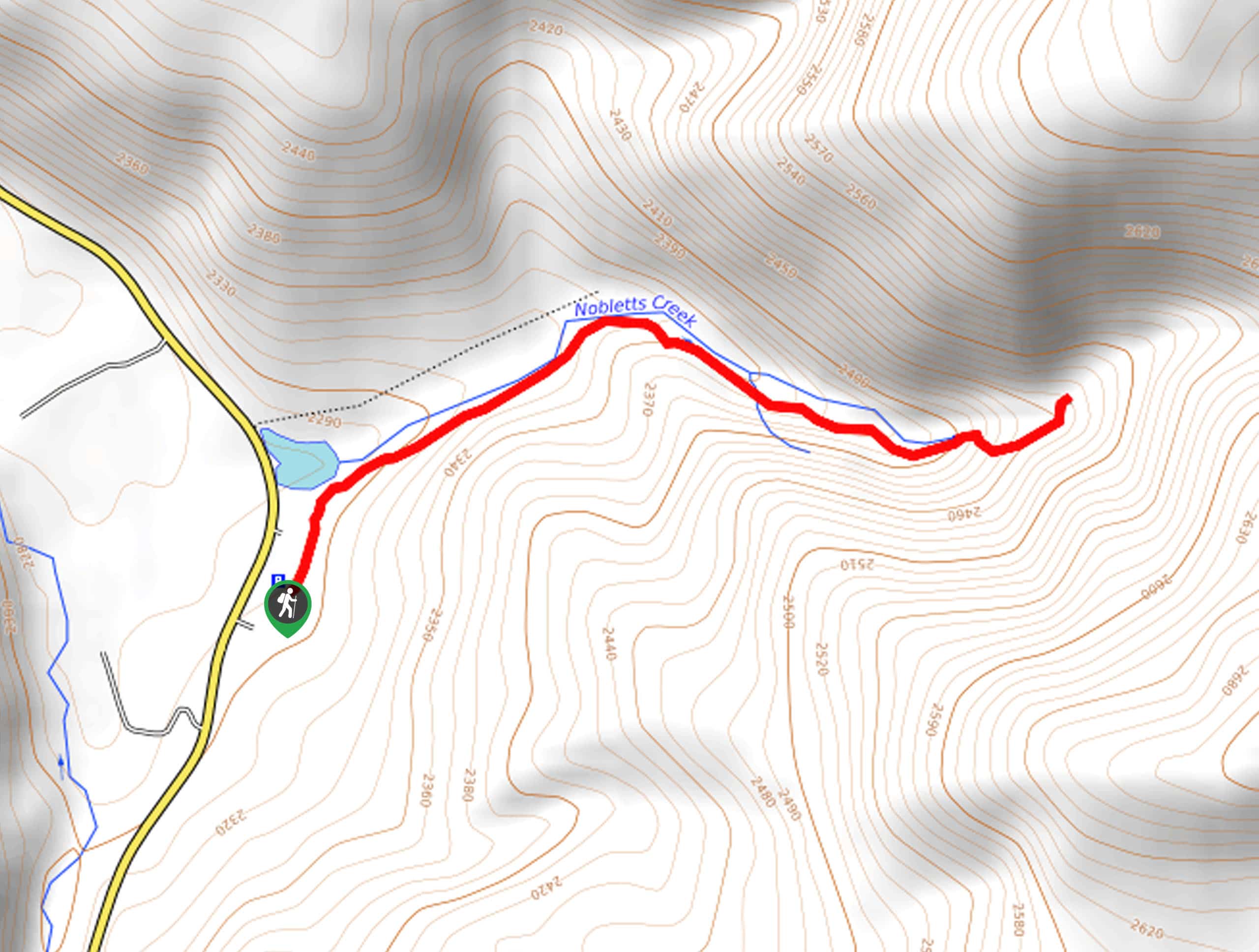
Nobletts Creek Trail Description
The Nobletts Creek Trail is a wonderful hike east of Park City, Utah. This trail can get buggy in the early summer, especially around dusk, so we recommend bringing along some bug repellent or long layers if you are heading out at that time of year. This trail makes a fantastic snowshoeing route in the winter, with incredible views of the surrounding forest blanketed in freshly fallen snow. A great route for kids of all ages and hikers of all abilities, The Nobletts Creek Trail is sure to become a family favorite.
From the Nobletts Creek Trailhead, follow the well-marked path along Nobletts Creek for 1.2mi.
Once you reach the Creek’s end, simply turn around and retrace your steps back to the trailhead where you began.
Similar hikes to the Nobletts Creek Trail hike

Skull Crack Trail
Despite the foreboding name, the Skull Crack Trail is a fantastic hike in the Uinta-Wasatch-Cache National Forest. This trail follows…
Pine Valley Trail
The Pine Valley Trail is a wonderful route just southeast of Kamas, Utah. This trail is a lovely hike in…
Oakley Ridge Trail
The Oakley Ridge Trail is a gorgeous route just east of Oakley, Utah. This trail is moderately challenging with steep…
Comments