Cedar Hollow Loop
View Photos
Cedar Hollow Loop
Difficulty Rating:
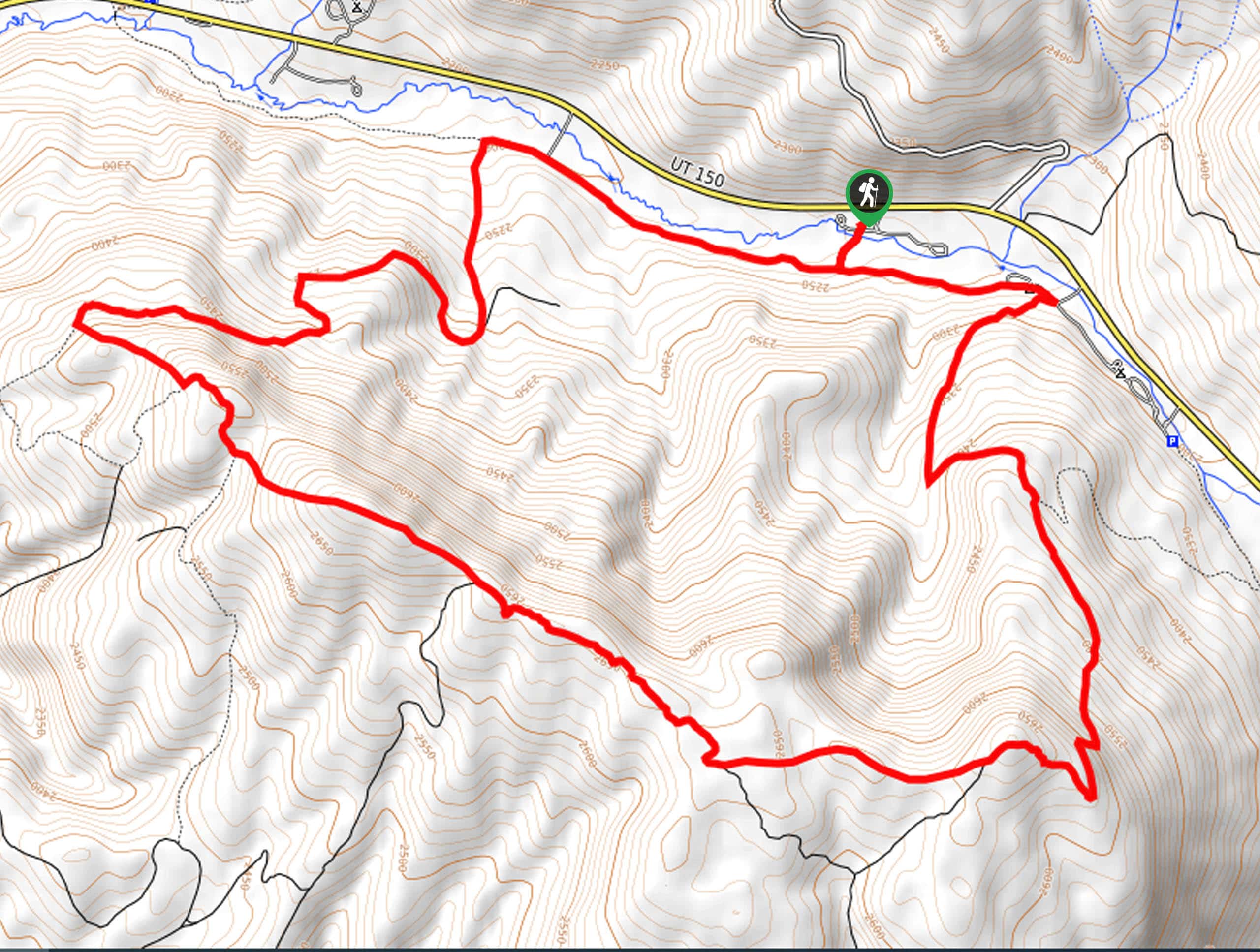
The Cedar Hollow Trail is a great 10.0mi loop east of Kamas, Utah. This trail is great for hiking and trail running in the summer months and snowshoeing in the winter. No matter what time of year you visit, the Cedar Hollow Loop is a lovely place to unwind and enjoy the beauty of the Utah wilderness.
Getting there
This hike begins at the Taylors Fork Campground on the south side of highway 150, 9.0mi east of Kamas, Utah.

About
| Backcountry Campground | Beaver Creek Campground, Taylor Fork Campground, Shingle Creek Campground |
| When to do | Year-round |
| Pets allowed | Yes |
| Family friendly | No |
| Route Signage | Poor |
| Crowd Levels | Low |
| Route Type | Circuit |
Cedar Hollow Loop
Elevation Graph
Weather
Cedar Hollow Loop Description
The Cedar Hollow Trail is a gorgeous loop located just east of Kamas, Utah. This trail can be tricky to find and is overgrown in some sections. We recommend printing or downloading a map of the loop beforehand and bringing along a GPS unit if you have it. In the summertime, the Cedar Hollow Loop is a great place to unwind and enjoy the lush Uinta forest alongside family, friends, or your adventure pup. In the winter, the Cedar Hollow Loop is transformed into a fantastic snowshoeing circuit with incredible views and the peace and quiet of winter in the mountains.
To hike the Cedar Hollow Loop, begin at the Taylors Fork Campground on the south side of Highway 150. From the campground, head south to follow the loop clockwise. Stick to your right at the many divides along the trail to make your way back around to the campground where you began.
If you are looking for more to explore in the area, check out the Slate Creek Loop nearby.
Similar hikes to the Cedar Hollow Loop hike

Willard Creek Waterfall Trail
The Willard Creek Trail is an adventurous yet beautiful hike on the eastern edge of Willard, Utah. This trail is…

Skull Crack Trail
Despite the foreboding name, the Skull Crack Trail is a fantastic hike in the Uinta-Wasatch-Cache National Forest. This trail follows…

Box Elder Creek Trail
The Box Elder Creek Trail is a lovely hike northeast of Salt Lake City. This trail is used by both…
Comments