Sweetwater Wetlands Loop
View Photos
Sweetwater Wetlands Loop
Difficulty Rating:
The Sweetwater Wetlands Loop leads you a short distance around one of the most important functional, environmental, and educational sites of the City of Tucson’s reclaimed water system. The Sweetwater Wetlands were constructed in 1996 to handle backwash water from the reclaimed water plant. Now, the site is a wetland that exclusively uses reclaimed water. The entire wetland has 2.5mi of trails, but this loop covers a quick 1.0mi section. Around 1000ft of the wetland pathways are paved and ADA-approved for wheelchair users.
This quick little nature walk is suitable for all ages and all skill levels. It’s flat, either paved or on 3.4-inch gravel, and easy to navigate. Note that dogs, horses, and bikes are not allowed in this area.
Getting there
The trailhead for the Sweetwater Wetlands Loop is off W Sweetwater Drive.

About
| Backcountry Campground | No |
| When to do | October-May |
| Pets allowed | No |
| Family friendly | Yes |
| Route Signage | Average |
| Crowd Levels | Moderate |
| Route Type | Loop |
Sweetwater Wetlands Loop
Elevation Graph
Weather
Sweetwater Wetlands Loop Description
The Sweetwater Wetlands Loop is a one-mile stroll around a wetland supported entirely by reclaimed water. This site was developed by the City of Tucson in 1996 to handle backlash filter water from the city’s water reclamation system. These days, it hosts a wetland ecosystem.
There are 2.5mi of trails to enjoy in the vicinity of the wetlands, but this route covers a shorter 1.0mi loop around the pools. It’s a perfect pick for a weekend walk, and thanks to its flat trail, this route is suitable for all ages and skill levels. Some of the pathways in this area are paved and ADA-approved for wheelchair users.
A water fountain and hand wash station are available on the trail, but we still recommend bringing a water bottle with you. It can get very hot in the Tucson area during the summer months, so having hydration on hand is important even for short walks like this one.
Bikes, horses, and dogs are not allowed on this path. Please take care on the clay-rich soil in the area, which can become quite slippery if it’s rained recently.
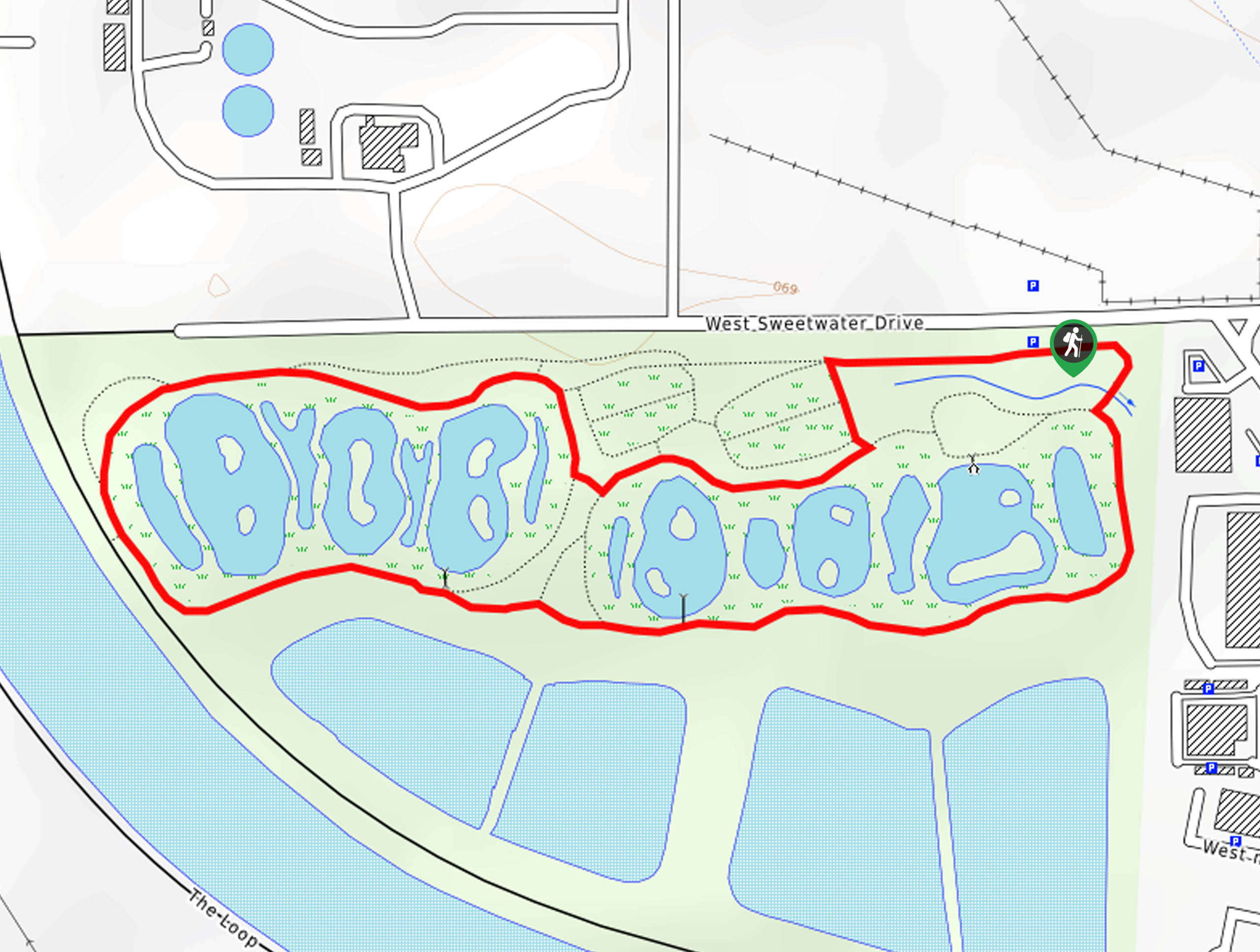
This loop can be completed either way, but we’ll describe it counterclockwise. From the trailhead, go right. At the first junction, take a left, keeping left through one junction and then turning right at the next. Follow this path as it skirts a pond, then continue around the next.
Approaching the Santa Cruz River, curve to your left for a few steps along the water. Continue on this path to two viewpoints over the wetlands. Stick to this trail until it rounds to your left, bringing you back to the trailhead.
Should you want a longer walk, there’s a trail that follows the Santa Cruz River that can be hiked as far as you like before turning back.
Hiking Route Highlights
Sweetwater Wetlands
The Sweetwater Wetlands were created in 1996 by the City of Tucson to handle backwash filter water from the city’s water reclamation system. The wetlands support a variety of plant and animal species and walking trails around the ponds offer visitors the opportunity to enjoy this pleasant space. With a flat elevation profile and great footing, the trails around the wetlands are suitable for all.
Frequently Asked Questions
Are dogs allowed at the Sweetwater Wetlands?
Dogs are not allowed at the wetlands.
Can you fish in the Sweetwater Wetlands?
No, fishing is not permitted here.
How do the Sweetwater Wetlands use reclaimed water?
Water is naturally filtered as it moves through the wetlands. It’s then recharged in basins and reclaimed for use in golf courses, parks, and schools.
Insider Hints
This is a stroller-friendly trail.
Similar hikes to the Sweetwater Wetlands Loop hike

Shantz, Cholla, and Cactus Forest Loop
The Shantz, Cholla, and Cactus Forest Loop is an easy trail in Tucson’s Saguaro National Park East. The star of…

Cactus Forest, Squeeze Pen, and Pink Hill Loop
The Cactus Forest, Squeeze Pen, and Pink Hill Loop is an easy trail in Tucson’s Saguaro National Park East. This…
Dripping Spring via Sutherland Trail
Starting off in Tucson’s lovely Catalina State Park, the hike to Dripping Springs on Sutherland Trail is a charming easy…
Comments