Sentinel Peak Hike
View Photos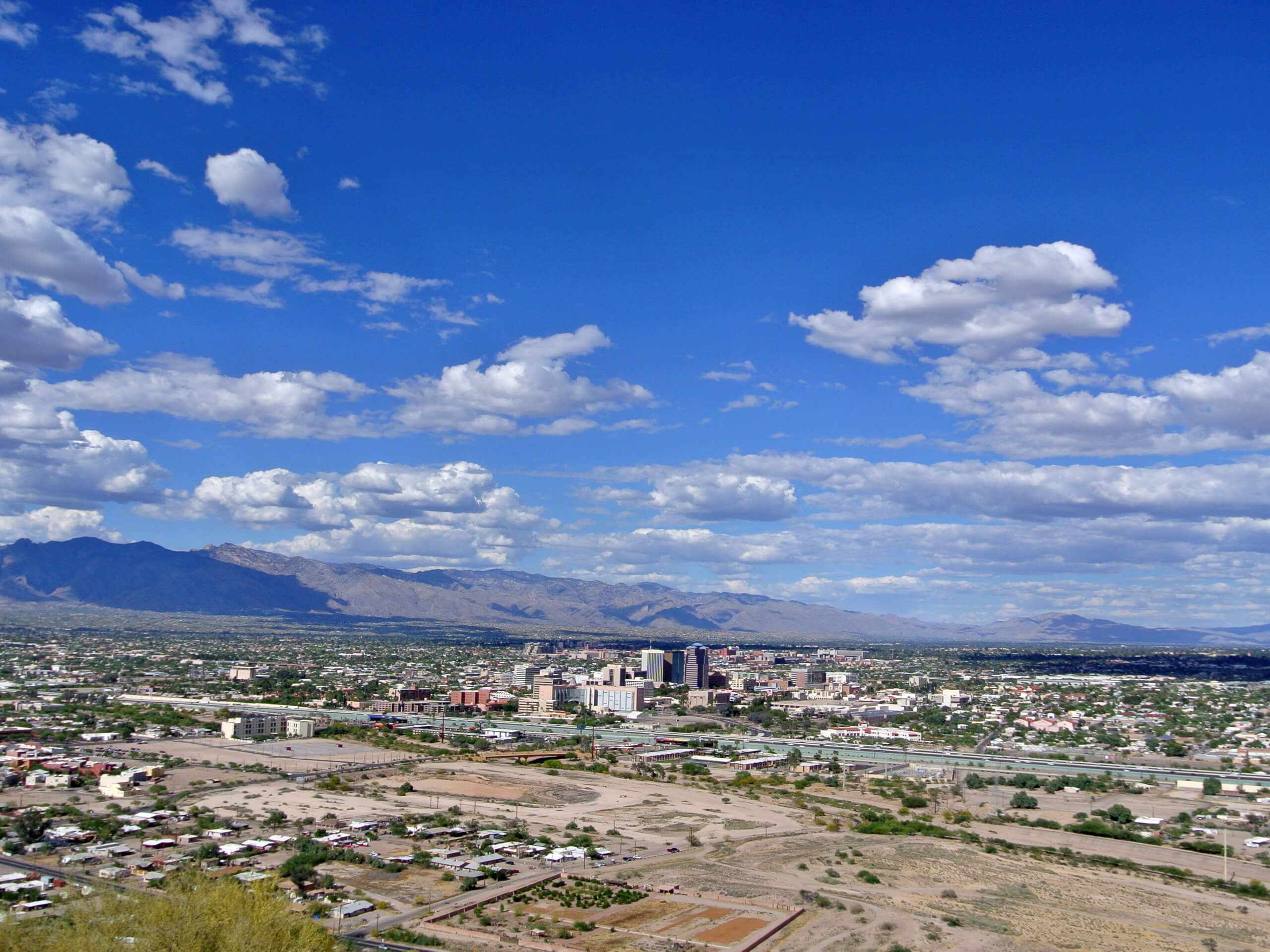
Sentinel Peak Hike
Difficulty Rating:
The Sentinel Peak hike near Tucson is a quick win, offering panoramic views of Tucson and the surrounding mountains on an easy 1.7mi loop. This hike is ideal if you want a quick leg-stretcher, are taking the kids out, or if you want some time outside but can’t go far or be gone for too long. The elevation gain is mostly gentle and the route is paved and easy to follow.
Sentinel Peak is a prominent landmark. It’s also known as “A” Mountain for its University of Arizona logo on the mountain, which was built by students in 1916. Most days, the mountain sees hundreds of hikers and bikers making their way up the road that encircles the mountain’s peak.
Getting there
The trailhead for the Sentinel Peak hike is off S Sentinel Peak Road.

About
| Backcountry Campground | No |
| When to do | October-May |
| Pets allowed | Yes - On Leash |
| Family friendly | Yes |
| Route Signage | Average |
| Crowd Levels | High |
| Route Type | Loop |
Sentinel Peak Hike
Elevation Graph
Weather
Sentinel Peak Hike Description
The Sentinel Peak hike is a very popular easy trail in Tucson. This route climbs around the top of Sentinel Peak, also known as “A” Mountain for the University of Arizona logo on its slopes. The logo was created by students in 1916, and each year’s homecoming is started with a lighting of the A.
Before it was claimed by the university, Sentinel Peak was used for signal fires by Native American inhabitants. Crops were grown along its base and it was later used in the Civil War.
Sentinel Peak is a 2897ft mountain made of up of layers of igneous rock from volcanic activity in years past. The mountain is a small part of the rich archeological history of the Santa Cruz Valley, which dates back over 4,000 years.
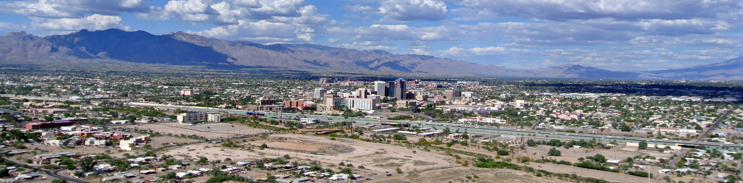
The hike up Sentinel Peak is quick and easy. With gentle elevation gain and a paved path, we recommend it for all ages and skill levels. The views of Tucson and the surrounding mountains are great, spanning in all directions.
This route has no shade and the temperatures in Tucson can soar. You’ll want to make sure you get out early enough to finish before the heat of the day sets in. Bring water and wear sunscreen.
While dogs are allowed on this trail on leash, we recommend either leaving them at home or putting boots on them due to the broken glass commonly found on this trail. Unfortunately, the mountain occasionally attracts partiers who don’t clean up after themselves. Watch your step.
From the trailhead, head up S Sentinel Peak Road to where it splits. Stay right to wrap around the southern face of the mountain, which has a view of the Santa Cruz River and South Tucson.
Round the peak, stopping at the viewpoint that looks out over the city and the Pusch Ridge Wilderness. Continue around the north end of the peak, looking over at Tumamoc Hill on your return route. Where the trail reconnects, retrace your route back to the parking lot.
Hiking Route Highlights
Tucson
On Sentinel Peak, your view of Tucson is unimpeded and wide. Home to the University of Arizona, Tucson is the second-largest city in Arizona after Phoenix. Tucson was founded as a military fort by the Spanish in 1775, became part of Mexican Sonora in 1821, and then was acquired by the United States in 1853. The name Tucson comes from the Spanish Tucsón, which means “at the base of the black hill.” This is in reference to the basalt-covered Sentinel Peak. Tucson is surrounded by five mountain ranges.
Frequently Asked Questions
Was Sentinel Peak in Tucson hit by a meteor?
There is a crater on the north side of Sentinel Peak that’s long been the source of local legend. The crater was not created by a meteor, though. It’s the site of an old quarry.
Can you drive around Sentinel Peak?
Yes, the road loops all the way around the mountain.
What time is A Mountain open?
The gate hours for this trail are 9 AM to 8 PM Monday to Saturday and 9 AM to 6 PM Sunday. Hours are subject to change.
Insider Hints
We recommend wearing sneakers or boots on this hike to protect your feet from broken glass.
Similar hikes to the Sentinel Peak Hike hike

Shantz, Cholla, and Cactus Forest Loop
The Shantz, Cholla, and Cactus Forest Loop is an easy trail in Tucson’s Saguaro National Park East. The star of…

Cactus Forest, Squeeze Pen, and Pink Hill Loop
The Cactus Forest, Squeeze Pen, and Pink Hill Loop is an easy trail in Tucson’s Saguaro National Park East. This…

Hugh Norris, Sendero Esperanza, and Dobbie Wash Loop
The Hugh Norris, Sendero Esperanza, and Dobbie Wash Loop is a bit of a mouthful, but it’s a great hike…
Comments