
Rock Wren and Starr Pass Hike
View Photos
Rock Wren and Starr Pass Hike
Difficulty Rating:
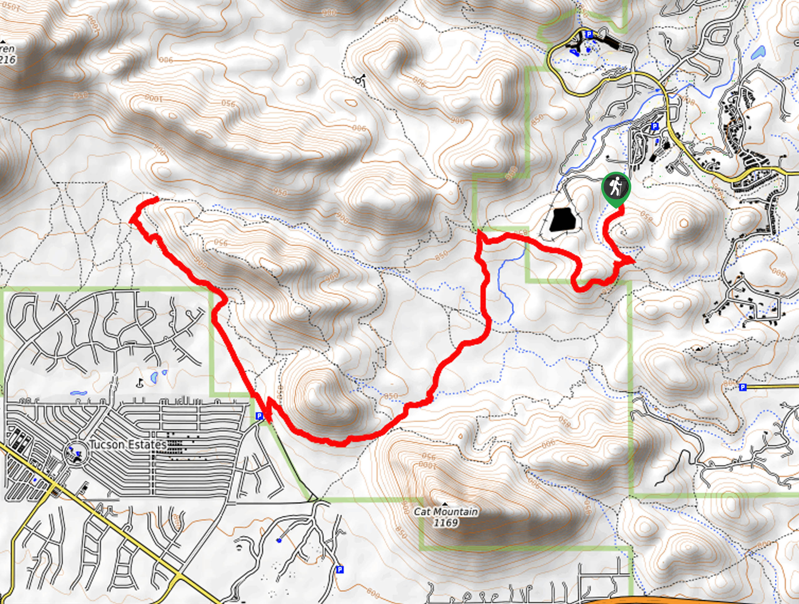
The Rock Wren and Starr Pass Hike is an enjoyable jaunt from one side of Tucson Mountain Park to the other, offering a 9.6mi journey through nature. This trail is rated as moderately difficult. This hike is well marked and offers the chance to see some local wildlife (including coyotes, so remember that dogs are not permitted on this trail). The route also connects to a wider range of trails, so you could easily extend to personalize your adventure if you wanted to. Note that this is a longer out and back hike that is similar to but different from the Starr Pass and Rock Wren Loop. Wear sturdy boots for this rocky trail.
Getting there
The trailhead for the Rock Wren and Starr Pass Hike is at the end of Clearwell Road.

About
| Backcountry Campground | No |
| When to do | October-May |
| Pets allowed | No |
| Family friendly | Yes |
| Route Signage | Good |
| Crowd Levels | Moderate |
| Route Type | Out and back |
Rock Wren and Starr Pass Hike
Elevation Graph
Weather
Rock Wren and Starr Pass Hike Description
Tucson Mountain Park has lots of trails that can make for memorable active outings, and the Starr Pass and Rock Wren Trail is a route known for its awesome Sonoran Desert scenery and moderate challenge. This 9.6mi trail is well marked, never very steep, and allows you to appreciate the plants and animals that call this park home. This route is quite rocky, so we recommend sturdy boots. Bring plenty of water and avoid hiking in the heat of the day if you can. Additionally, remember that dogs are not permitted in the park, which is important to adhere to due to coyote sightings on this trail.
From the trailhead at the end of the street, you’ll take Rock Wren Trail down into the park. There are two junctions early on in the hike; go straight through the first and stay right at the second. At the 5-way junction, take the route on your left, which is David Yetman Trail. Stay left at the split to hike between Cat Mountain and its sister mountain to the northwest. Hike alongside the neighborhood and the ridge to the trail’s end at a T-junction. Turn back here and retrace your steps.
Similar hikes to the Rock Wren and Starr Pass Hike hike

Shantz, Cholla, and Cactus Forest Loop
The Shantz, Cholla, and Cactus Forest Loop is an easy trail in Tucson’s Saguaro National Park East. The star of…

Cactus Forest, Squeeze Pen, and Pink Hill Loop
The Cactus Forest, Squeeze Pen, and Pink Hill Loop is an easy trail in Tucson’s Saguaro National Park East. This…

Hugh Norris, Sendero Esperanza, and Dobbie Wash Loop
The Hugh Norris, Sendero Esperanza, and Dobbie Wash Loop is a bit of a mouthful, but it’s a great hike…
Comments