Pima Canyon Trail
View Photos
Pima Canyon Trail
Difficulty Rating:
The Pima Canyon Trail is a 10.1mi hike in the Coronado National Forest near Tucson that is rated as moderate. This route leads you through a canyon with impressive riparian habitats and rich biodiversity. Hiking in a canyon underneath the Pusch Ridge, the views get better and better as you climb. Since this hike sees so much traffic through such a sensitive natural area, please remember to leave no trace. Stay on the marked trails, take your trash with you, leave dogs at home, and appreciate wildlife from afar.
While this route is rated as moderate for its dispersed elevation gain, it is a long hike. Come prepared with water, food, sun protection, and GPS navigation.
Getting there
The trailhead for the Pima Canyon Trail is at the end of E Magee Road.

About
| Backcountry Campground | No |
| When to do | October-May |
| Pets allowed | No |
| Family friendly | Older Children only |
| Route Signage | Average |
| Crowd Levels | High |
| Route Type | Out and back |
Pima Canyon Trail
Elevation Graph
Weather
Pima Canyon Trail Description
The Pima Canyon Trail is a gorgeous 10.0mi trek in the Pusch Ridge Wilderness near northeastern Tucson. This hike climbs along a canyon underneath Pusch Ridge where a river flowing along the canyon floor supports a rich riparian habitat. The biodiversity in the canyon is a draw for many.
Because this hike travels through sensitive natural habitats, it’s extremely important that you hike in a way that leaves a minimal impact on the ecosystem. Stay on the trail and don’t veer off, take your trash with you, and leave lots of room between yourself and wildlife. Dogs are not allowed on this trail.
The canyon can get quite hot, so we recommend avoiding this hike in the summertime. No matter what time of year you visit in, bring lots of water, bring snacks, and wear sun protection. While this route is moderate in its elevation profile, it might be a bit too long for younger children, but you can enjoy the views for as long as you like before turning back.
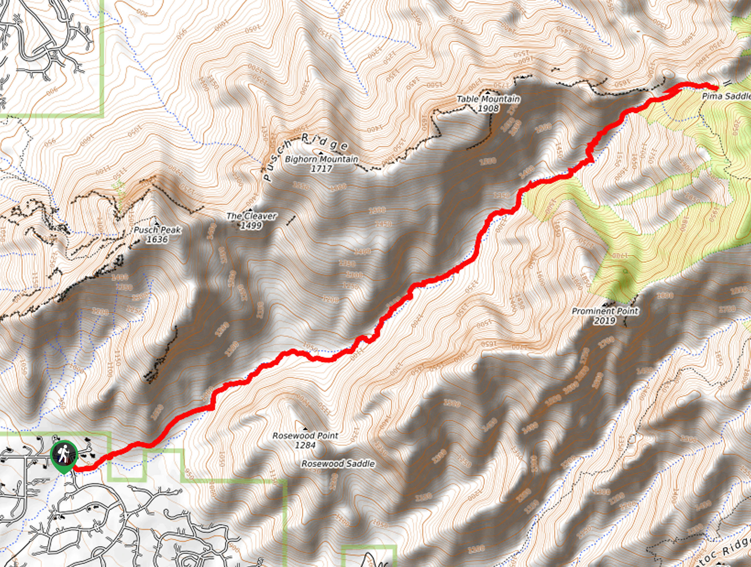
From the trailhead, take Pima Canyon Trail across E Barrel Cactus Court. Follow the route into the mouth of the canyon. It’s a straightforward trip from here.
As you hike, look for the many resident and migratory birds. Look for javelina and jackrabbits as well. If you’re lucky, you’ll spot surefooted bighorn sheep up on the hills. This area used to be a haven for the sheep, who were early wiped out by human use. Eventually, bighorn sheep were reintroduced and numbers are slowly on the rise.
The view into the canyon improves the further you go, but the route gets harder to follow the further you get into the canyon. You’ll pass Pusch Peak, Bighorn Mountain, and Table Mountain on your left before approaching Mount Kimball on your right.
As you approach Mount Kimball, you’ll have a great view of Window Rock and Cathedral Rock. The route ends where another trail turns to climb up Mount Kimball. From here, turn back and retrace your steps through the canyon to the trailhead.
Hiking Route Highlights
Pima Canyon
Pima Canyon is a V-shaped canyon that runs from the southeastern base of Pusch Peak to Mount Kimball in the Pusch Ridge Wilderness of the Coronado National Forest. Because of the canyon’s proximity to Tucson, it’s become a popular place for hikers to explore. With resident bighorn sheep, javelina, and many species of birds, this canyon is an excellent example of the unique ecosystems that can thrive where the desert finds water.
Frequently Asked Questions
Are dogs allowed in Pima Canyon?
No, dogs are not allowed on this trail.
Are there mountain lions in Pima Canyon?
The canyon has been closed in the past to protect the health and safety of humans and resident mountain lions, who have interacted with humans in the past. Mountain lion sightings in the canyon are not especially common.
Is there water in Pima Canyon?
There is a river that runs through the canyon, but it may be dry depending on recent rainfall and the time of year.
Insider Hints
This area is subject to closure to protect bighorn sheep during lambing season. Closures usually run from January 1 through April 30.
Similar hikes to the Pima Canyon Trail hike

Shantz, Cholla, and Cactus Forest Loop
The Shantz, Cholla, and Cactus Forest Loop is an easy trail in Tucson’s Saguaro National Park East. The star of…

Cactus Forest, Squeeze Pen, and Pink Hill Loop
The Cactus Forest, Squeeze Pen, and Pink Hill Loop is an easy trail in Tucson’s Saguaro National Park East. This…

Hugh Norris, Sendero Esperanza, and Dobbie Wash Loop
The Hugh Norris, Sendero Esperanza, and Dobbie Wash Loop is a bit of a mouthful, but it’s a great hike…
Comments