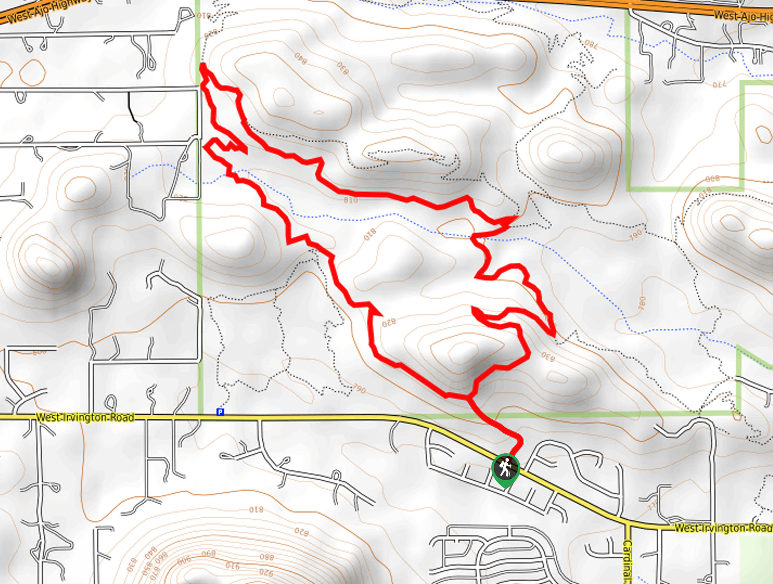
Bittersweet, Camaro, and Sunset Pass Loop
View Photos
Bittersweet, Camaro, and Sunset Pass Loop
Difficulty Rating:
The Bittersweet, Camaro, and Sunset Pass Loop is a moderately difficult 4.0mi hiking and mountain biking route in the south end of Tucson Mountain Park. This trail is a great pick for a casual nature walk, and we love all the cactus beside the trail. This route isn’t well-marked at the beginning, so bring a map or GPS route for reference. Expect heavy traffic.
Getting there
The trailhead for the Bittersweet, Camaro, and Sunset Pass Loop is on W Irvington Road.

About
| Backcountry Campground | No |
| When to do | October-May |
| Pets allowed | No |
| Family friendly | Yes |
| Route Signage | Average |
| Crowd Levels | High |
| Route Type | Loop |
Bittersweet, Camaro, and Sunset Pass Loop
Elevation Graph
Weather
Bittersweet, Camaro, and Sunset Pass Loop Description
The Bittersweet, Camaro, and Sunset Pass Loop is a beautiful, easy trail for hikers and mountain bikers. It’s mostly flat with lots of interesting cacti to admire on the side of the trail, especially when they bloom in the early spring. We like this route for an evening nature walk with family since it’s so beginner-friendly.
You can access the trail as designated on the map, but some users prefer the availability of parking on W Coyote Ridge Trail, joining the trail at the northwestern corner. Either way will get you on the trail. It can be hot out here, even in the winter, so bring lots of water with you.
From the trailhead, go right onto Bittersweet Trail as it climbs and then descends a rocky hill. Cross a wash and take a left onto Sunset Pass Trail. Take this up to the sharp left turn onto Bittersweet Trail. This area is where you’ll enter the trail if you park on Coyote Ridge TrailThe route heads directly southeast to the trailhead from this point.
Similar hikes to the Bittersweet, Camaro, and Sunset Pass Loop hike

Shantz, Cholla, and Cactus Forest Loop
The Shantz, Cholla, and Cactus Forest Loop is an easy trail in Tucson’s Saguaro National Park East. The star of…

Cactus Forest, Squeeze Pen, and Pink Hill Loop
The Cactus Forest, Squeeze Pen, and Pink Hill Loop is an easy trail in Tucson’s Saguaro National Park East. This…

Hugh Norris, Sendero Esperanza, and Dobbie Wash Loop
The Hugh Norris, Sendero Esperanza, and Dobbie Wash Loop is a bit of a mouthful, but it’s a great hike…
Comments