Marsh Marigold Lake
View Photos
Marsh Marigold Lake
Difficulty Rating:
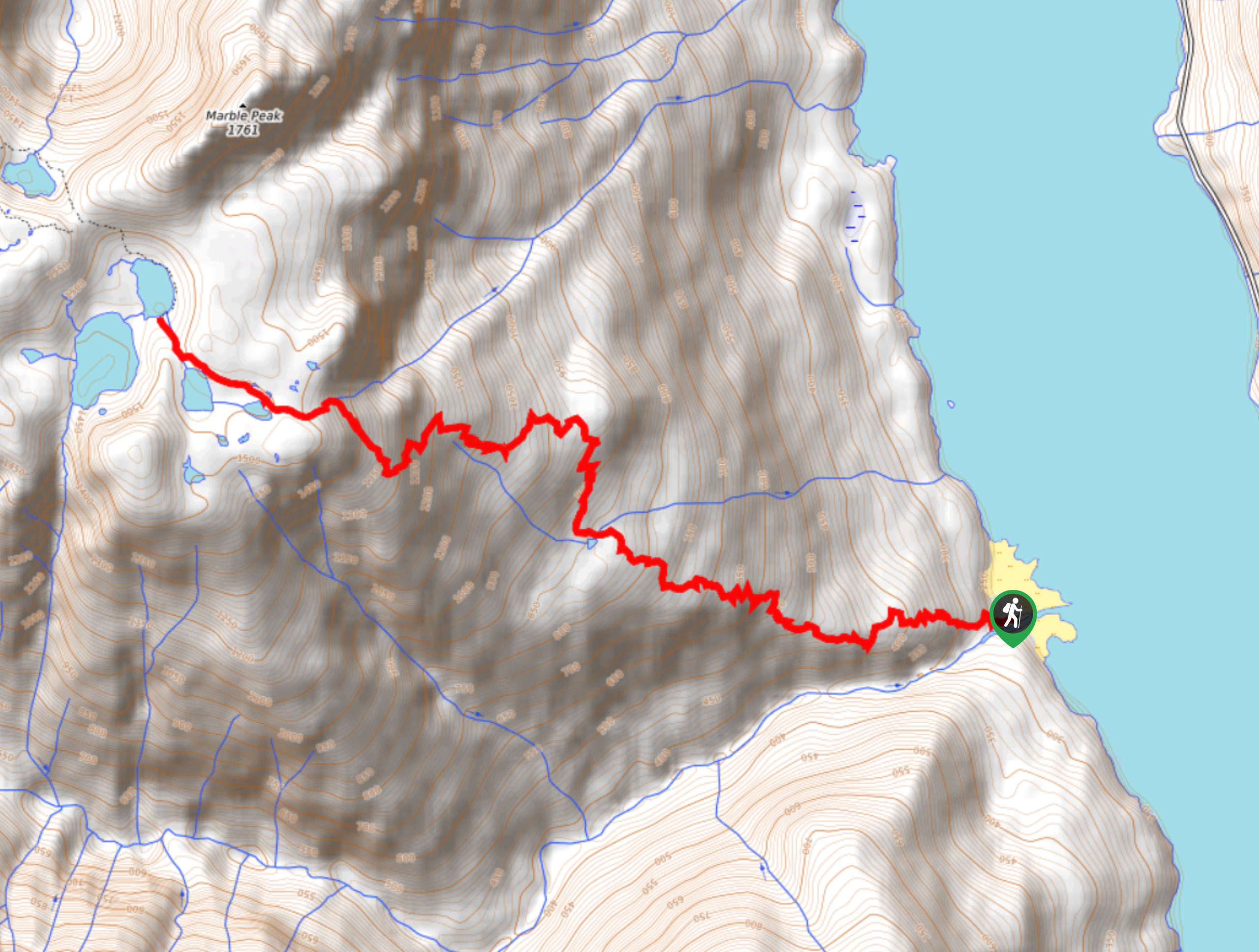
The trek up to Marsh Marigold Lake is a 8.7mi out-and-back hiking route that will reward you with awesome alpine views and the chance to visit three scenic lakes. The trail climbs uphill through a long series of switchbacks that wind through a beautiful stretch of mixed forest to reach the rocky landscape around the lakes. The trailhead is only accessible by boat, so hikers will need to make arrangements to cross Buttle Lake safely.
Getting there
The trail leading up to Marsh Marigold Lake sets out from the Phillips Creek Marine Campground. This campsite is accessible by boat only, so hikers will need to paddle across Buttle Lake to reach the trailhead.

About
| When to do | May-October |
| Backcountry Campsites | Phillips Creek Marine Campground |
| Pets allowed | Yes - On Leash |
| Family friendly | No |
| Route Signage | Average |
| Crowd Levels | Low |
| Route Type | Out and back |
Marsh Marigold Lake
Elevation Graph
Weather
Marsh Marigold Lake Description
Hiking to Marsh Marigold Lake is a full-day adventure due to the winding uphill route and the inaccessibility of the trailhead. The trail sets out from the Phillips Creek Marine Campground on the western shore of Buttle Lake and doesn’t have any roads leading into it. Hikers will first need to paddle across the lake to reach the trailhead. The lake usually experiences high winds in the middle hours of the day, so make sure to cross over either before noon or after 5 pm to have the most favourable conditions. The route itself also has a high elevation gain of 4367ft; however, this is spread across countless switchbacks to lessen the hike’s difficulty. Make sure to wear proper hiking footwear and bring plenty of snacks and water for the long uphill journey.
While the route up to Marsh Marigold Lake may be a long uphill climb, the views overlooking Strathcona Provincial Park are well worth the effort. After making your way across Buttle Lake—an entire journey in itself—you will set out on a gradual climb through a mixed forest of hemlock, douglas fir, and yellow cedar trees along a path that very quickly transitions into a long series of winding switchbacks. Reaching the top of the trail, you will pass by Limestone and Globe Flower lakes before arriving at the final destination of Marsh Marigold Lake. The terrain in this area is an almost desert-like rock dotted with mixed vegetation and seems out of place in the alpine landscape. From here, you can look out over the tranquil lakes and surrounding mountain peaks that include Marble Peak to the north and Morrison Spire to the west. It might be a bit tricky to get to, but Marsh Marigold Lake is one hike that should be on your list of trails in Strathcona Provincial Park.
Setting out from the trailhead next to the campground, follow the trail to the west as it heads into the tree cover and climbs gently uphill. The trail has a nice variation in terrain throughout its length, and hikers will experience a mix of gravel, dirt, loose rock, and rocky bluffs at various stages of the hike. As you make your way up the hillside, the trail will follow a series of switchbacks that lessen the physical strain of the ascent.
As you make your way closer to Marsh Marigold Lake, you will notice that the yellow cedars become more prevalent in the surrounding landscape as you gain elevation and eventually break out of the tree cover. Along the final approach to the lake, you will cross over some rocky terrain with a light smattering of vegetation that resembles a desert landscape more than the lush forests and rugged peaks of British Columbia.
Take some time to explore this scenic area around Limestone, Globe Flower, and Marsh Marigold Lakes. As you walk along the rocky shores, you will have some pretty awesome views of the surrounding mountains that stand high above the calm waters of the lakes and offer a stark contrast to the blue sky above. After you’ve spent enough time exploring and admiring the picturesque landscape, make your way back along the trail to return to the Phillips Creek Marine Campground.
Insider Hints
Cross Buttle Lake before noon or after 5 pm to avoid high winds while out on the water.
The most popular launch point for crossing the lake is the Augerpoint Trailhead.
Bring lots of water and snacks for the winding uphill journey.
Similar hikes to the Marsh Marigold Lake hike
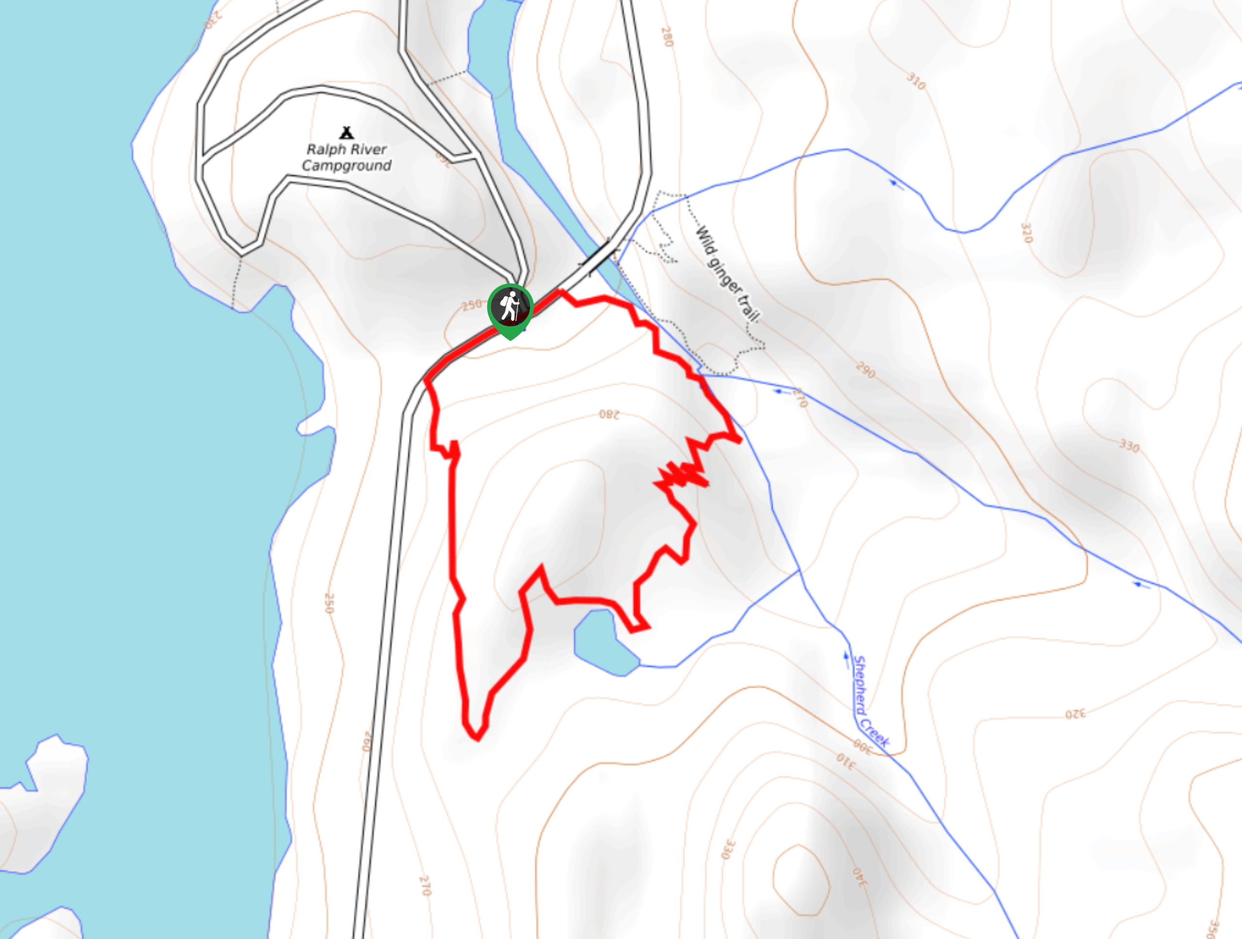
Shepherd Creek Trail
The Shepherd Creek Trail is a quick 1.1mi hike in Strathcona Provincial Park that offers a perfect way…
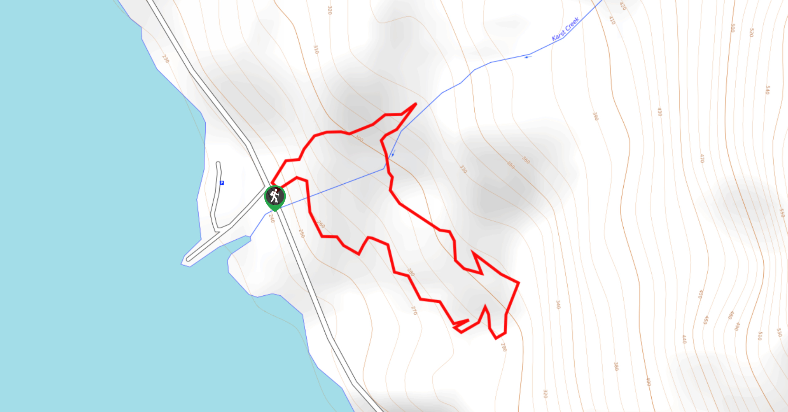
Karst Creek Trail
The Karst Creek Trail is a 0.8mi hiking loop that will take you through a beautiful stretch of…
Old Cabin Loop
The Old Cabin Loop is a 1.5mi scenic hiking route within Strathcona Provincial Park that travels around a…
Comments