Arnot Creek Trail
View Photos
Arnot Creek Trail
Difficulty Rating:
The Arnot Creek Trail is an unassumingly beautiful adventure through the tree-burned valley bounded by craggy granite bluffs. Located amongst towering Sierra summits, wandering along the snowmelt stream, hiking the Arnot Creek Trail makes for a relaxing experience.
Getting there
Access the trailhead off Stanislaus NF Road 7N83.

About
| Backcountry Campground | Backcountry Camping, wilderness permit required. |
| When to do | June-October |
| Pets allowed | Yes - On Leash |
| Family friendly | Yes |
| Route Signage | Average |
| Crowd Levels | Low |
| Route Type | Out and back |
Arnot Creek Trail
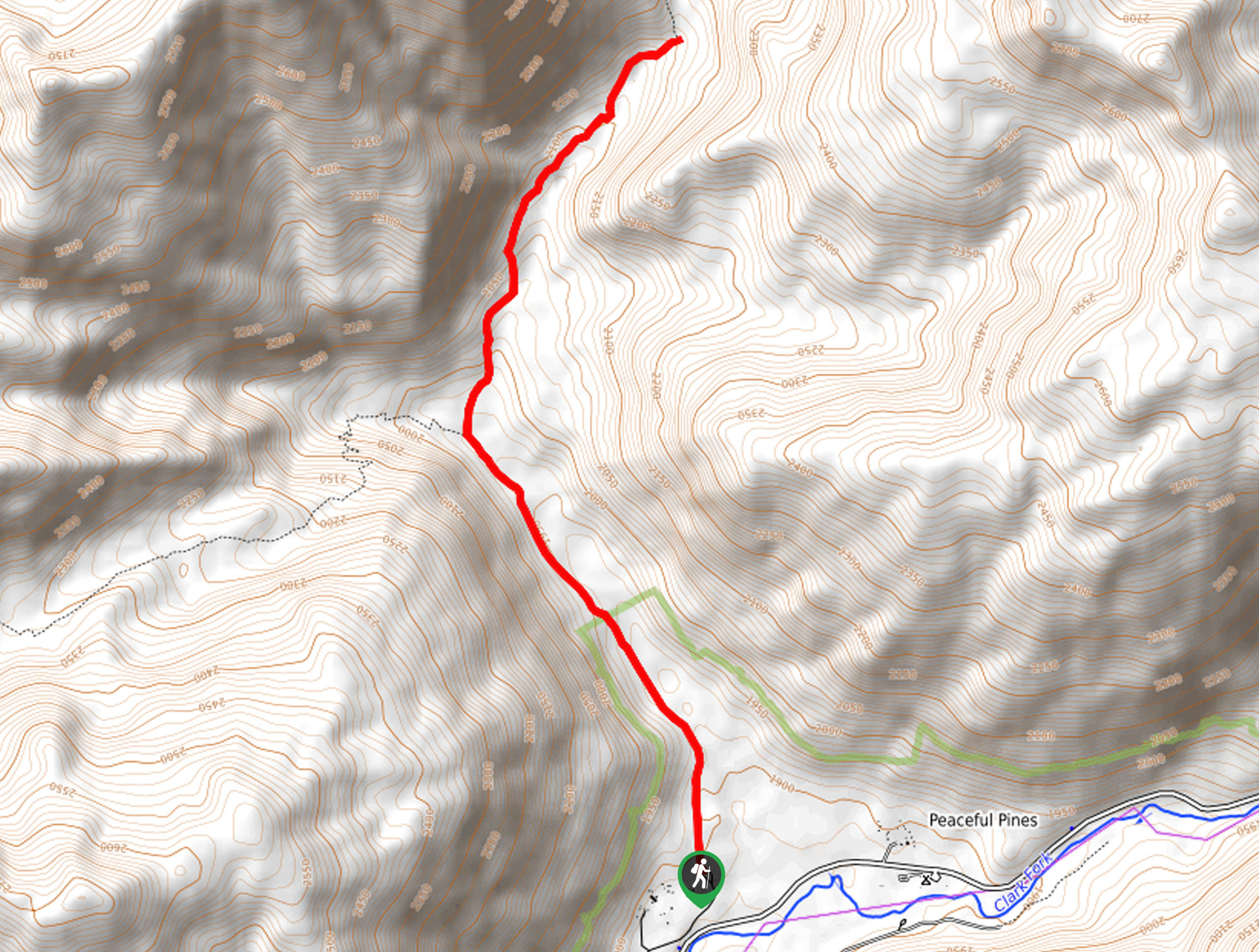
Elevation Graph
Weather
Arnot Creek Trail Description
The Arnot Creek Trail would be an excellent addition to your Stanislaus National Forest hiking itinerary. This wonderful trail offers a great workout, motivating adventurers with beautiful scenery every step of the way. Note much of this path is exposed, so make sure to wear SPF and a sunhat to avoid overexposure. Additionally, the terrain is rocky and uneven, so take your time and mind your footing!
Setting out from the Arnot Creek Trailhead, track north along the Stanislaus NF Road 7N39Y. This path will travel up a gradual incline through Woods Gulch and along Arnot Creek. As you hike further into the wilderness, you will notice that there is plenty of tree burn from a previous wildfire. Enjoy the scenes of the encompassing granite bluffs and sights of Iceberg Peak. Eventually, you will reach an intersection, veer right onto the Highland Lakes-Arnot Creek Loop.
Hike this scenic path northeast along the gurgling waters of Arnot Creek. Though you can continue along this route longer, we turned around at the bend between Iceberg Peak and Lightning Mountain. When you are ready to head back, simply retrace your steps the way you came to the trailhead.
Similar hikes to the Arnot Creek Trail hike
Folger Peak Hike
The Folger Peak Hike is an awesome adventure that boasts 360-degree, panoramic vistas of the high country. This wonderful adventure…
Long Gulch Ridge Loop
Adventure the Long Gulch Ridge Loop for an exciting, scenic experience in the Stanislaus National Forest. This shared route travels…

Eagle Meadow Hike
Hiking the Eagle Meadow Trail makes for a unique experience. Hike amongst equestrians through the expansive meadowlands along Eagle Creek…
Comments