Cat Lake Trail
View Photos
Cat Lake Trail
Difficulty Rating:
The Cat Lake Trail is a short 0.9mi hiking route that loops around Cat Lake and offers scenic woodland views. With a short overall distance, easy terrain, and minimal elevation changes, this trail is a perfect hiking option for families with young children that are looking to get out and explore the outdoors. This route is also dog friendly, making it a great place for your best friend to play in the water after a leisurely walk.
Getting there
To reach the parking area for the Cat Lake Trail from Squamish, drive north on BC-99 N and make a right turn onto Cheekeye Forest Service Road. After 1.3mi, you will reach the parking area at the Cat Lake Recreation Site.

About
| When to do | Year-Round |
| Backcountry Campsites | Cat Lake Recreation Site |
| Pets allowed | Yes |
| Family friendly | Yes |
| Route Signage | Average |
| Crowd Levels | Low |
| Route Type | Circuit |
Cat Lake Trail
Elevation Graph
Weather
Cat Lake Trail Description
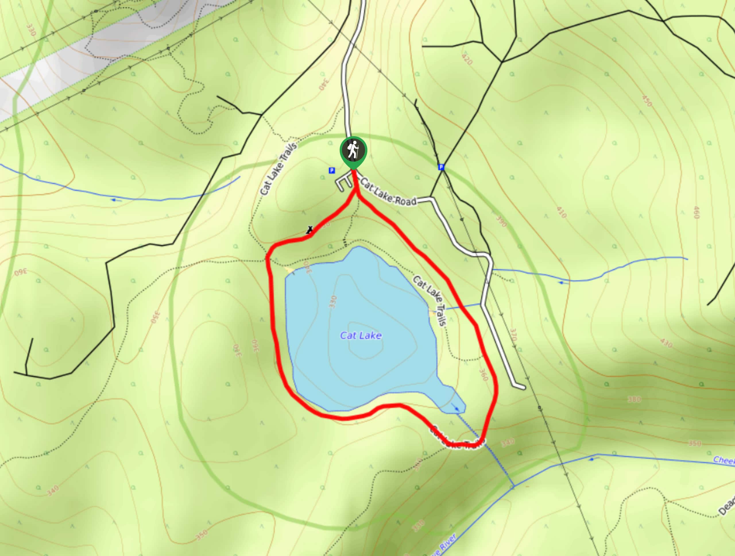
The Cat Lake Trail is a short hiking route just north of Squamish that meanders for 0.9mi around the shores of the lake. This trail is more of a leisurely walk through the Cat Lake Recreation Site than a true hike, so if you are looking for a longer or more challenging trail, you might consider tackling other nearby routes like those around Brohm or Alice lakes.
While this trail might not be very long, it does offer some scenic woodland views, as well as the opportunity to experience the beauty and tranquility of Cat Lake. Here, you can meander along the forested path as you gaze out over the calm, mirror-like waters of the lake before wrapping up your quick hike and jumping in for a swim. The Cat Lake Trail is a great little hike to get out and stretch your legs along the trail during a long weekend of camping at the nearby recreation site.
Setting out from the parking area, pick up the trail off of Cat Lake Road and follow it south, heading right at the fork to follow the trail in a counterclockwise direction around the lake. Here, you will pass through the campsites of the Cat Lake Recreation Site before arriving at a five-way intersection in the trail. Take the second trail on your left to continue south around the shores of the lake.
Passing by the beach access point and wooden dock stretching out into the water, hikers will continue south, following the trail as it eventually turns east and arrives at a fork along the southern shore of Cat Lake. Head straight through the fork and cross over the creek to continue on the trail as it leads north, running parallel to Cat Lake Road and the shore of the lake itself.
From here, you will cross over another creek and pass by a beach access point along the final stretch of the trail. This will once again pass through the campsites found within the recreation site on the way to return to the parking lot. Having completed the Cat Lake Trail, take some time to explore the network of hiking routes in the area or jump in the cool waters of the lake for a quick swim. There is a lot to do in the surrounding area, so make a camping weekend of it and hit the trails around Cat Lake.
Insider Hints
Several washroom facilities can be found near the campsite area.
There are several beaches and docks around the lake that you can use to access the water.
The area is home to a decent network of trails. If you are looking to extend your hike, there are several routes that branch off around the camping area.
Similar hikes to the Cat Lake Trail hike
Four Lakes Trail
The Four Lakes Trail is a 4.5mi hiking route that travels through Alice Lake Provincial Park on a…
Wonderland Lake Loop
The Wonderland Lake Loop is a short trail that sets out from the top of the Sea to Sky Gondola…
Coho Park Trail
The Coho Park Trail is a short 1.7mi hiking route that takes hikers through a beautiful stretch of…
Comments