
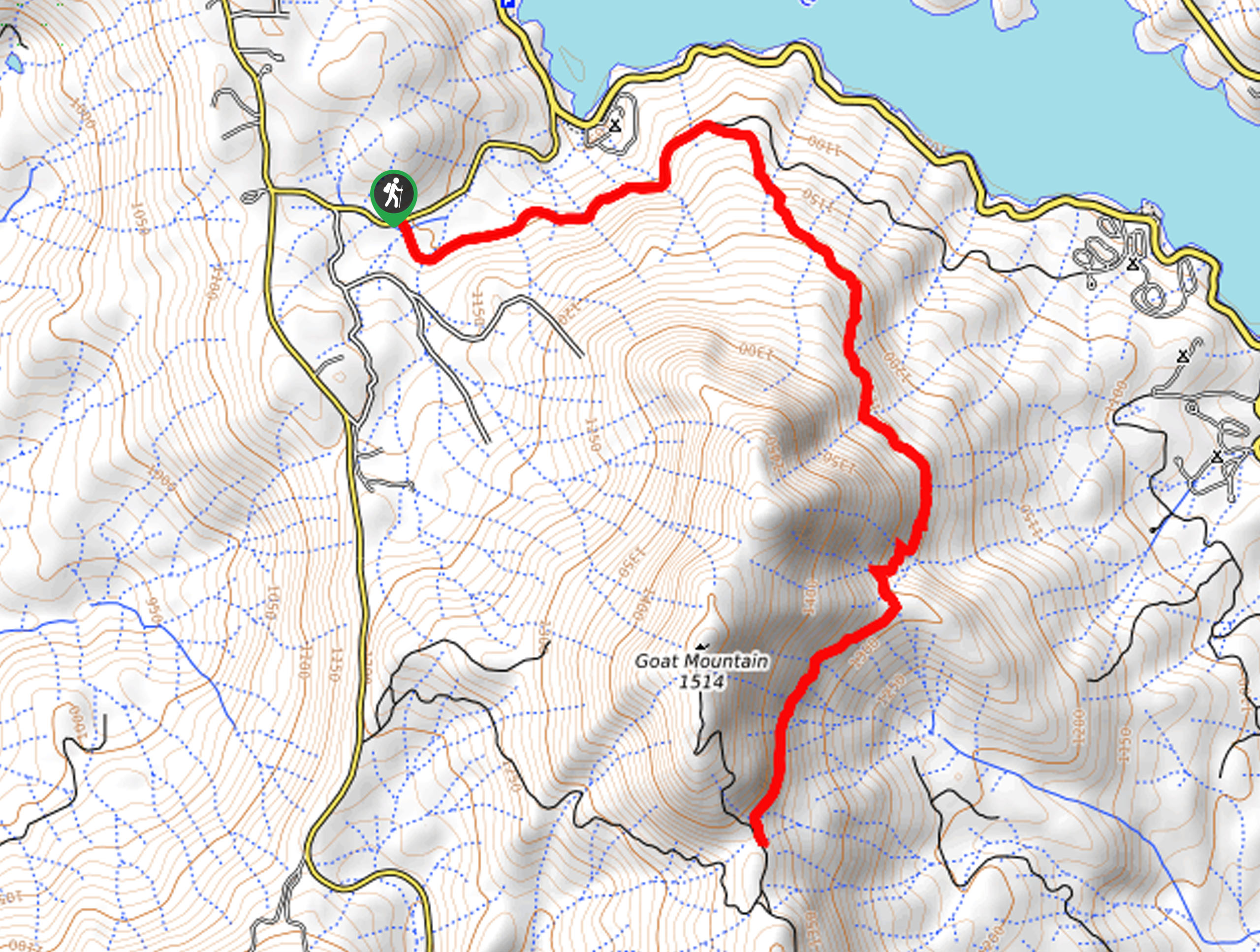
Goat Mountain Trail
View Photos
Goat Mountain Trail
Difficulty Rating:
The Goat Mountain Trail is perhaps the greatest of all time. This epic excursion boasts mesmerizing vistas of the High Sierra and Bass Lake below. Offering great views and a good workout, what more could you ask for?
Getting there
The Goat Mountain Trail departs from the Cedar Bluff Trailhead off Road 426.

About
| Backcountry Campground | No |
| When to do | Year-round |
| Pets allowed | Yes - On Leash |
| Family friendly | Older Children only |
| Route Signage | Average |
| Crowd Levels | Moderate |
| Route Type | Out and back |
Goat Mountain Trail
Elevation Graph
Weather
Goat Mountain Trail Description
The Goat Mountain Hike would be a great addition to your Sierra NF itinerary. Wander through the mixed coniferous forest along the dirt track along the mountainside, exposing panoramic views of the High Sierra. Shared with mountain bikers, this route is single-track in areas, so it is important to be mindful of passers-by. Accessible year-round, you can enjoy a different perspective of the trail with the help of microspikes or snowshoes. Note this is the shorter route up to the summit.
Setting out from the trailhead, the Goat Mountain Hike follows the Cedar Bluff Road into the forestlands. Hiking east, the path will guide you over several snowmelt streams. When hiking in the springs, you might just have to do some rock hopping. Soon the path will divert northeast, where you will confront an intersection. Here, veer left along a more primitive route. From here, the route will begin to climb more intensely, offering awesome views of Bass Lake and distant panoramas of the snow-capped Sierra Nevada Peaks.
Follow this path through the woodlands, and you will ultimately reach a junction with the Goat Mountain Electronics Site Road. Here, turnaround, and retrace your footing along the path back to the trailhead.
Similar hikes to the Goat Mountain Trail hike
Post Corral Meadows Trail
A popular backpacking route turned epic day hike, the Post Corral Meadows Trail is an epic back-country expedition. Hike amongst…
Chiquito Pass Trail
The Chiquito Pass Trail is arguably one of the most scenic adventures in the Sierra National Forest. Wander up through…
Wuh-Ki'o Trail
The Wuh-Ki'o Trail is an unassumingly picturesque adventure in the Sierra National Forest. Traveling through meadowlands, brush, over bridges, and…
Comments