Moro Rock Trail
View Photos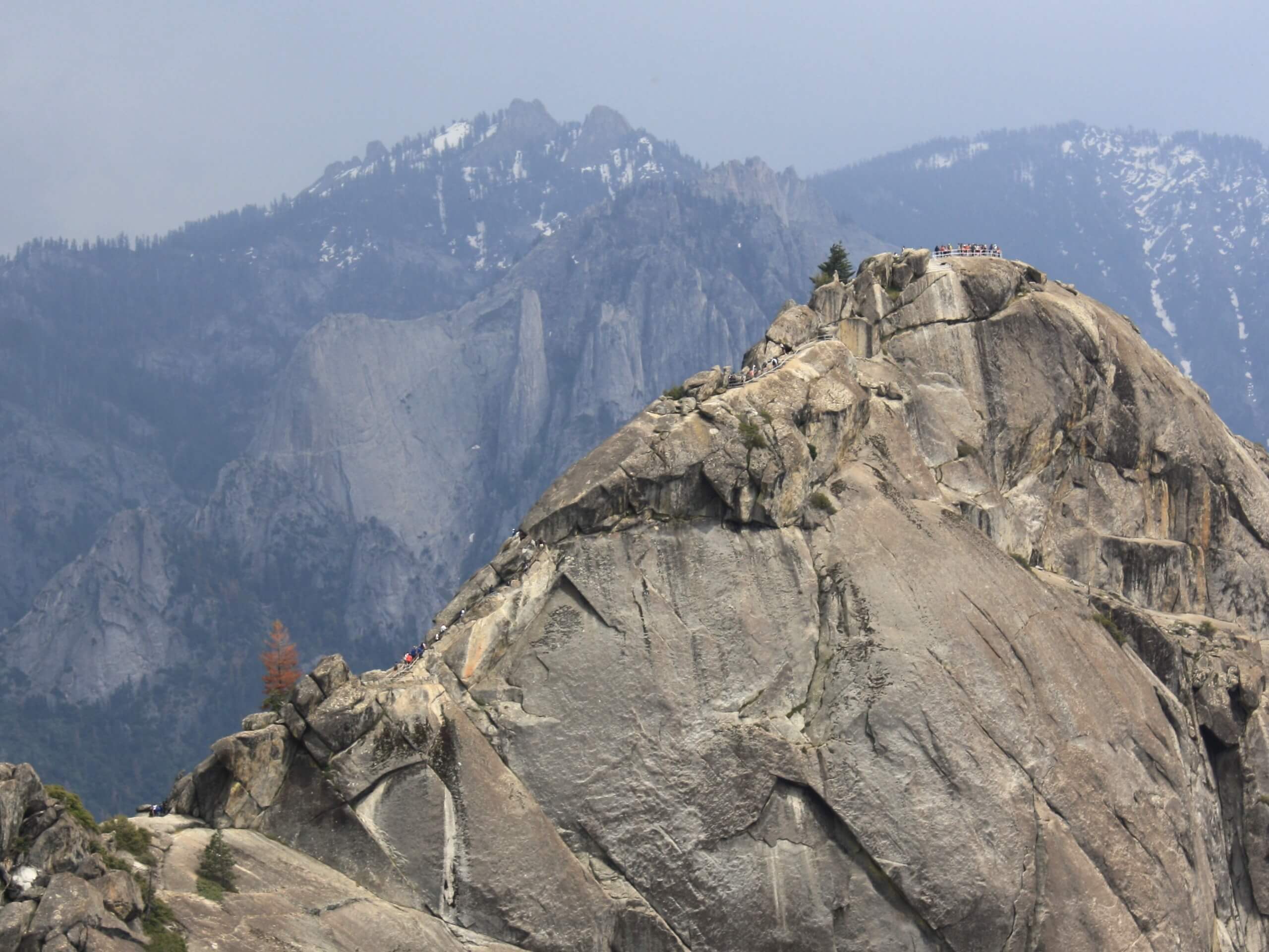
Moro Rock Trail
Difficulty Rating:
The Moro Rock Trail is a wonderful adventure in the Sequoia National Park that boasts incredible views of the Great Western Divide. Climb up a 350-step staircase to the summit of the granite monolith and you will be rewarded for your efforts with the breathtaking alpine scenery.
Getting there
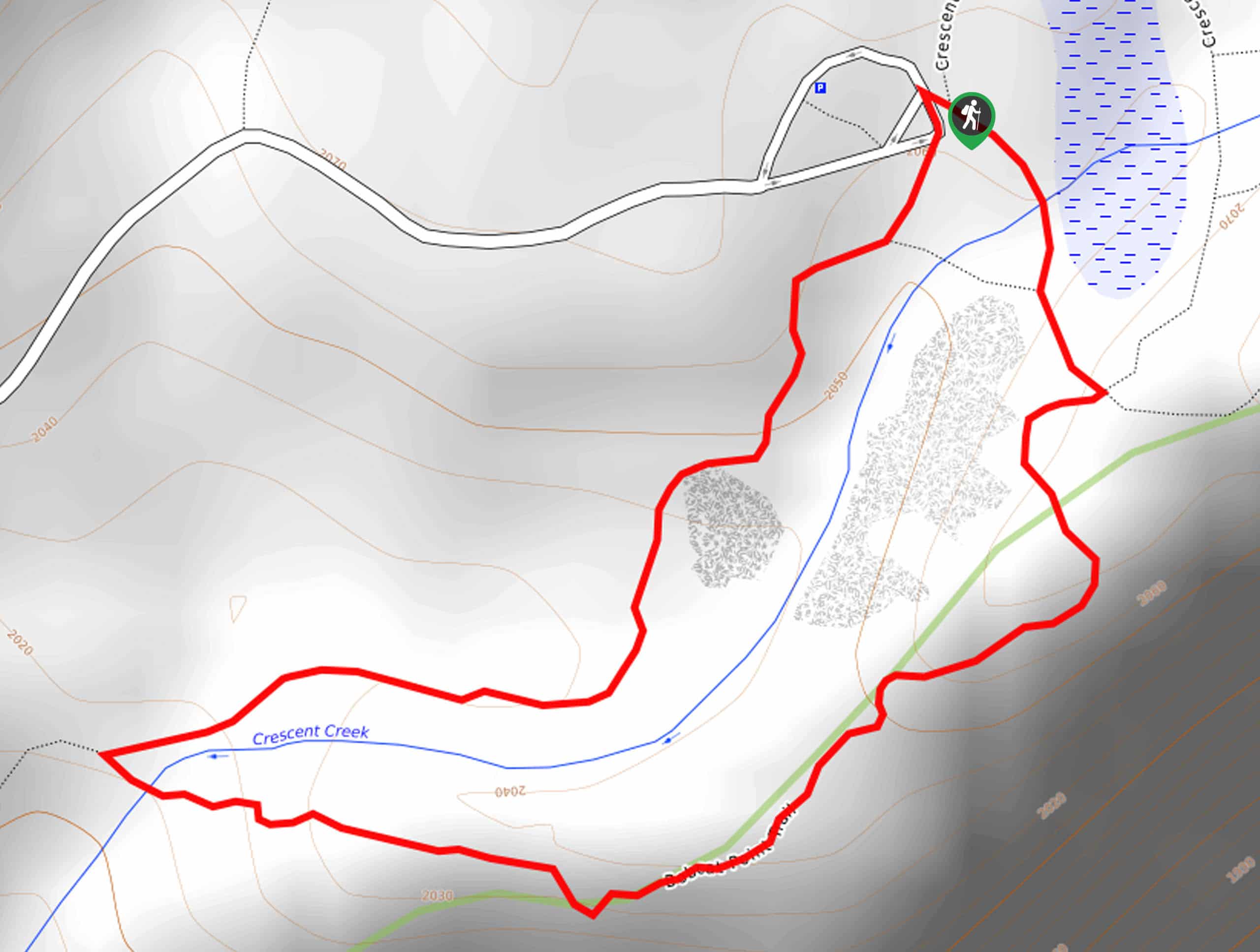
The Moro Rock Trail departs from the Moro Rock Trailhead off Moro Rock Loop.

About
| Backcountry Campground | No |
| When to do | May-October |
| Pets allowed | No |
| Family friendly | Yes |
| Route Signage | Good |
| Crowd Levels | High |
| Route Type | Out and back |
Moro Rock Trail
Elevation Graph
Weather
Moro Rock Trail Description
The Moro Rock Trail is an amazing adventure well worth a trip into the Sequoia National Park. Traveling up 300-odd steps to the summit of the granite outcrop, this route demands some stamina—though hikers of most skill levels and ages should be able to easily manage. Maintain on the established path at all times and keep an eye on children as the drop-offs on either side are precipitous.
Note the trail is closed in the winter months due to hazardous conditions, and in summer, free shuttles run from Giant Forest Museum to the Moro Rock parking area. The road closes to private vehicles, and shuttles on weekends are the only way to reach Moro Rock. Note entrance to the park costs $35USD per vehicle or $20USD per person for pedestrians or cyclists.
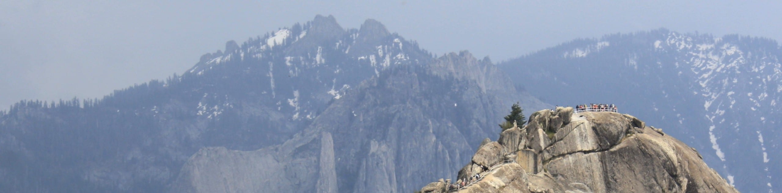
Indulge yourself in 360-degree, panoramic views of the High Sierra along the Moro Rock Trail. The rock in and of itself is a spectacular sight! The gigantic granite feature can be enjoyed from above or down below. Those with a fear of heights may want to experience the grandeur of the geological feature from the ground as the narrow path is bound by dramatic bluffs.
This route sees plenty of traffic, notably on summer weekends, so come prepared to share the trail. Those seeking a more tranquil experience are encouraged to head out in the early morning to avoid the rush and watch the sunrise. Don’t forget to charge your camera; the scenery along this route is picture-perfect! We love this hike if you can’t already tell, and we know you will too!
Embark on your adventure along the Moro Rock Trail from the trailhead off Moro Rock Loop. Setting you from here, you will be guided south, gradually climbing through the mixed coniferous forest of sugar and ponderosa pines. You will eventually graduate the timberline by navigating the first set of stairs, climbing up onto Moro Rock. From here, the path will increase in intensity as you climb up via several stone steps.
Take your time, and take breaks as needed as you ascend the granite outcrop. Navigating the narrow path, you will quickly be rewarded with impressive scenery. Once you ultimately reach the trail’s end, you will be overwhelmed by the 360-degree views. Notice the San Joaquin Valley and the foothills in the west and the Great Western Divide in the east. Revel in the beauty of the dramatic landscape, then carefully retrace your footing back down to the trailhead.
Trail Highlights
Moro Rock
Moro Rock is an impressive granite outcrop in the Sequoia National Park that stands at an elevation of 6725ft. The first staircase up to the top of the dome was constructed of wood in 1917 so that eager explorers, such as yourself, could hike up and enjoy the scenery from atop the outcrop without having to scale the sheer cliffside. Ultimately, these stairs were replaced in 1931 by the National Park Service, which carved a staircase into the rock. Those brave enough to climb up the vertiginous steps to the top of the dome-shaped granite monolith are rewarded with incredible views of the Great Western Divide.
Frequently Asked Questions
How many steps are there up to the summit of Moro Rock?
There are over 350 steps up to the top of Moro Rock.
Is the Moro Rock Trail difficult?
Though short, the Moro Rock Trail is steep, demanding the ascent of over 350 steps—so expect to sweat!
What can you see from atop Moro Rock?
From the summit of Moro Rock visitors will be granted breathtaking views of the Great Western Divide.
Insider Hints
Keep an eye on the skies—this rock is prone to lightning strikes
Head out at dawn or dusk to avoid the rush
After rainfall the terrain is extremely slippery
Make sure you are acclimated to the area’s elevation before heading out
Charge your camera—the views are picture-perfect
Leave your pup at home, pets are not allowed on this route
Similar hikes to the Moro Rock Trail hike

Eagle and Bobcat Loop Hike
The Eagle and Bobcat Loop Hike is an amazing adventure that the whole family can enjoy. Wander through luxuriant meadows…
Bobcat Point Loop Hike
Seeking incredible vistas of the Sierra Nevada Mountain Range? The Bobcat Point Loop Hike is an incredible adventure in the…

Huckleberry and Alta Loop Hike
The Huckleberry and Alta Loop Hike is a beautiful adventure that offers a wealth of incredible scenery for hikers to…
Comments