
Ladybug Camp Trail
View Photos
Ladybug Camp Trail
Difficulty Rating:
The Lady Bug Camp Trail offers a tranquil experience in the Sequoia National Park. This enchanting adventure travels through lush forestlands, picturesque meadows, along meandering creeks, and into a sequoia grove—what more could you ask for? Mountain views? This trek checks that box too.
Getting there
The Ladybug Camp Hike departs from the Ladybug Trailhead in the South Fork Campground off South Fork Drive.

About
| Backcountry Campground | No |
| When to do | Year-round |
| Pets allowed | No |
| Family friendly | Older Children only |
| Route Signage | Average |
| Crowd Levels | High |
| Route Type | Out and back |
Ladybug Camp Trail
Elevation Graph
Weather
Ladybug Camp Trail Description
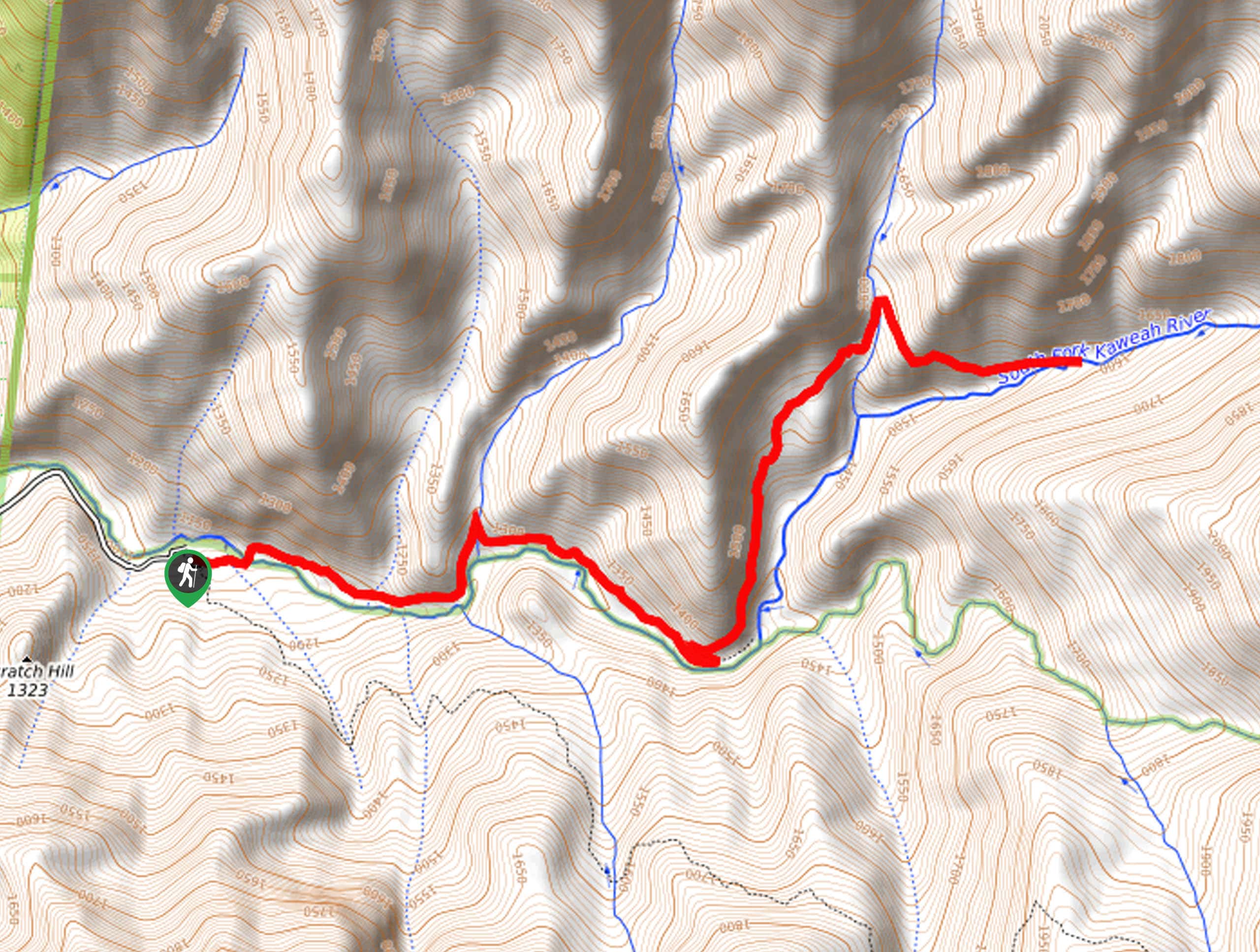
The Ladybug Camp Trail is a beautiful footpath that intermediate hikers and families with older children can enjoy. Immerse yourself into the vibrant wilderness and revel in the unrivaled scenery. Be sure to keep an eye out for orange lizards in the Kaweah River as you wander. Note the road to the trailhead is rough and rugged, so we suggest driving in a vehicle with high ground clearance. Don’t forget entrance to the park costs $35USD per vehicle or $20USD per person for pedestrians or cyclists.
Embark on your excursion along the Ladybug Camp Trail from the Ladybug Trailhead. Setting out from here, you will be guided eastwardly along the Ladybug Trail and over a footbridge above the South Fork of the Kaweah River. Beyond this point, the path meanders in the river valley through lush meadows and shaded tree stands. Eventually, you will reach an intersection at the Ladybug Camp—you still have some gas left in the tank, veer left onto the Whiskey Log Trail.
Follow this forested trail further into the wilderness to Cedar Creek. Here the path ends, but you will find a more primitive path that meanders into South Grove. Admire the towering sequoias, then retrace your steps along the route back to the trailhead.
Similar hikes to the Ladybug Camp Trail hike

Eagle and Bobcat Loop Hike
The Eagle and Bobcat Loop Hike is an amazing adventure that the whole family can enjoy. Wander through luxuriant meadows…
Pinto Lake Trail
Beckoning the exploration of intrepid spirits and experienced hikers, the Pinto Lake Trail is a no walk in the park.…

Huckleberry and Alta Loop Hike
The Huckleberry and Alta Loop Hike is a beautiful adventure that offers a wealth of incredible scenery for hikers to…
Comments