Big Baldy Ridge Trail
View Photos
Big Baldy Ridge Trail
Difficulty Rating:
The Big Baldy Ridge Trail is an amazing adventure that exhibits a diversity of flora and fauna in addition to breathtaking views of Kings Canyon and the Sierra Nevada Mountains. Demanding a modest effort, this route requires some stamina and navigational skills.
Getting there
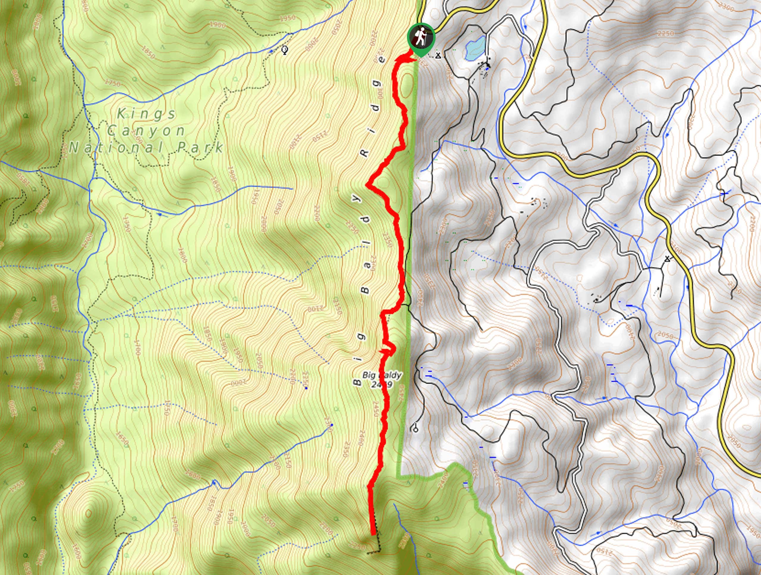
Access this hike via the Big Baldy Trailhead off Generals Highway.

About
| Backcountry Campground | No |
| When to do | March-November |
| Pets allowed | No |
| Family friendly | Older Children only |
| Route Signage | Poor |
| Crowd Levels | High |
| Route Type | Out and back |
Big Baldy Ridge Trail
Elevation Graph
Weather
Big Baldy Ridge Trail Description
Those seeking an intermediate hike in the Kings Canyon National Park will enjoy this nature trail. Explore forests of mixed conifers adorned with carpets of lush ferns before topping the timberline into the rocky oasis. Marvel at the remarkable views of the Sierra Nevada Mountain Range while getting in a wicked workout. This trail is not well marked, so the trail GPS will prove useful. Additionally, as much of the path is exposed be sure to pack plenty of water and dress in layers as insurance against changing conditions. Note entrance to the park costs $35USD per vehicle or $20USD per person for pedestrians or cyclists.
Embark on your adventure along the Big Baldy Ridge Hike from the Baldy Trailhead. Setting out from here, you will be guided southwardly; keep left at the first intersection. Gradually climbing, this undulating route will lead you through stands of coniferous forests before graduating the timberline. Gradually ascending the incline, the tree shade will become increasingly sparse, exposing awe-inspiring vistas of the Sierra Nevada Mountains. Soon you will summit Big Baldy, but this is not your adventure’s end.
Follow this route south to the craggy ridge that boasts incredible alpine panoramas. Revel in the beauty and grandeur of the mountainous landscape, then turn around and head back the way you came to the trailhead.
Similar hikes to the Big Baldy Ridge Trail hike

Eagle and Bobcat Loop Hike
The Eagle and Bobcat Loop Hike is an amazing adventure that the whole family can enjoy. Wander through luxuriant meadows…
Pinto Lake Trail
Beckoning the exploration of intrepid spirits and experienced hikers, the Pinto Lake Trail is a no walk in the park.…

Huckleberry and Alta Loop Hike
The Huckleberry and Alta Loop Hike is a beautiful adventure that offers a wealth of incredible scenery for hikers to…
Comments