
Soldier Wash Loop
View Photos
Soldier Wash Loop
Difficulty Rating:
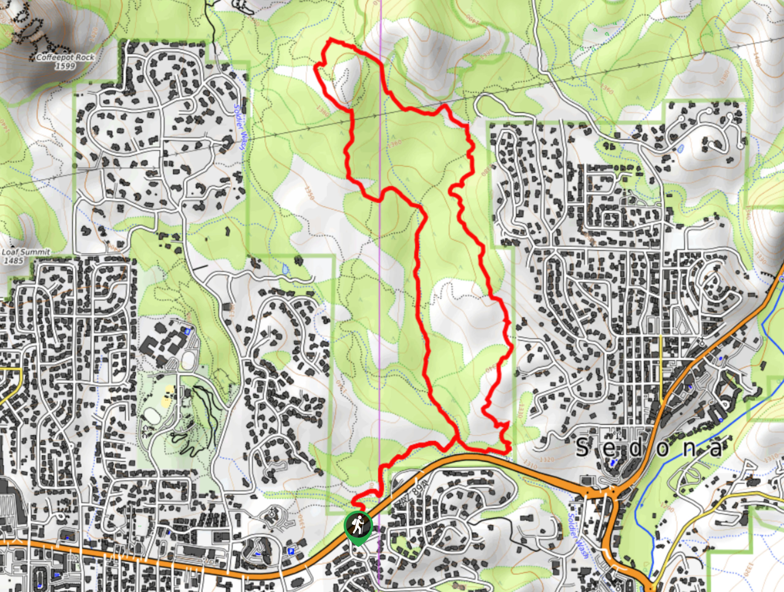
Soldier Wash Loop is a 4.2mi hike in Sedona that shows off the high desert scenery that this region is known for. This hike is good for all levels with just a touch of elevation gain and modest mileage. Keep an eye out for mountain bikers on this hike and remember to share the trail. Expect light traffic.
Getting there
The trailhead for the Soldier Wash Loop is off State Route 89A.

About
| Backcountry Campground | No |
| When to do | Year-round |
| Pets allowed | Yes - On Leash |
| Family friendly | Yes |
| Route Signage | Average |
| Crowd Levels | High |
| Route Type | Loop |
Soldier Wash Loop
Elevation Graph
Weather
Soldier Wash Loop Description
The Soldier Wash Loop is a fun trail with gorgeous desert scenery. It’s not as busy as many other hikes in Sedona are, making it a great pick on weekends when more popular trails are packed. You’ll need to share this trail with mountain bikers, but the views make it worth it.
Note that this trail is well signed, but mostly for mountain bikers. There isn’t signage for this trail as it’s known to hikers. Bring a map of your own or download a GPS track to follow.
From the trailhead, take Crusty Trail to the right. You’ll take a left onto Grand Central Trail, which runs right through the wash. Continue straight on here, going straight through where Manzanita Trail intersects and then again where Powerline Plunge intersects.
Take a left onto ant Hill Loop Trail and then a right onto Jordan Trail. Stay left onto Javelina and head back to the road, turning right onto Crusty again to reach the trailhead.
Similar hikes to the Soldier Wash Loop hike

Margs Draw Trail
Margs Draw Trail is a bit of a hidden gem. This trail doesn’t get as much traffic as other nearby…

Baby Bell, Llama, and Bail Loop
The Baby Bell, Llama, and Bail Loop is a 3.6mi hike in Sedona near Bell Rock and Courthouse…

Herkenham Trail
Herkenham Trail is a 2.0mi out and back trail in the Coconino National Forest near Sedona. This route…
Comments