
Hiline Trail
View Photos
Hiline Trail
Difficulty Rating:
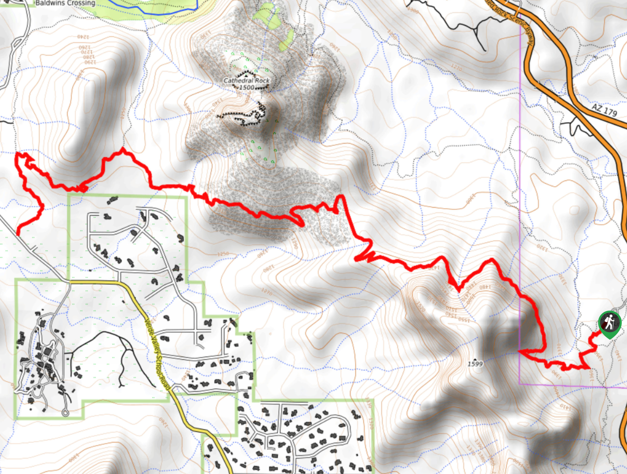
The Hiline Trail is a great pick for hikers in Sedona who want a perfect view of Cathedral Rock with a bit more distance and challenge than most other trails in the area. At 8.4mi long, it’s a fun moderate trip suitable for stronger beginners and older families. Expect moderate traffic on this hike, which is a refreshing break from the other packed trails around Cathedral Rock.
Getting there
The trailhead for Hiline Trail is off Red Rock Scenic Byway.

About
| Backcountry Campground | No |
| When to do | Year-round |
| Pets allowed | Yes - On Leash |
| Family friendly | Older Children only |
| Route Signage | Average |
| Crowd Levels | Moderate |
| Route Type | Out and back |
Hiline Trail
Elevation Graph
Weather
Hiline Trail Description
The Hiline Trail is a fantastic pick for hikers who want to enjoy a picture-perfect view of Cathedral Rock, but with a bit more effort required and a lighter crowd present than other trails. This 8.4mi hike is moderately difficult, letting you get your legs moving without being too demanding. The views are pristine!
Keep an eye out for mountain bikers on this trail, as you’ll need to do on many trails in the Sedona area.
From the trailhead, take Kaibab Trail to Yavapai Vista Trail to Slim Shady Trail. Take a right off slim Shady to Hiline Trail, hugging the base of the ridge above you. You’ll eventually climb up the ridge, which has an amazing view of Cathedral Rock. While the trail continues back down the ridge and ends at Baldwin Crossing Road, most hikers enjoy the viewpoint and then turn around.
If you want to finish out the hike, continue off the ridge and hike around the base of the butte in front of you. The trail then branches south to the road, where it ends.
Similar hikes to the Hiline Trail hike

Margs Draw Trail
Margs Draw Trail is a bit of a hidden gem. This trail doesn’t get as much traffic as other nearby…

Baby Bell, Llama, and Bail Loop
The Baby Bell, Llama, and Bail Loop is a 3.6mi hike in Sedona near Bell Rock and Courthouse…

Herkenham Trail
Herkenham Trail is a 2.0mi out and back trail in the Coconino National Forest near Sedona. This route…
Comments