
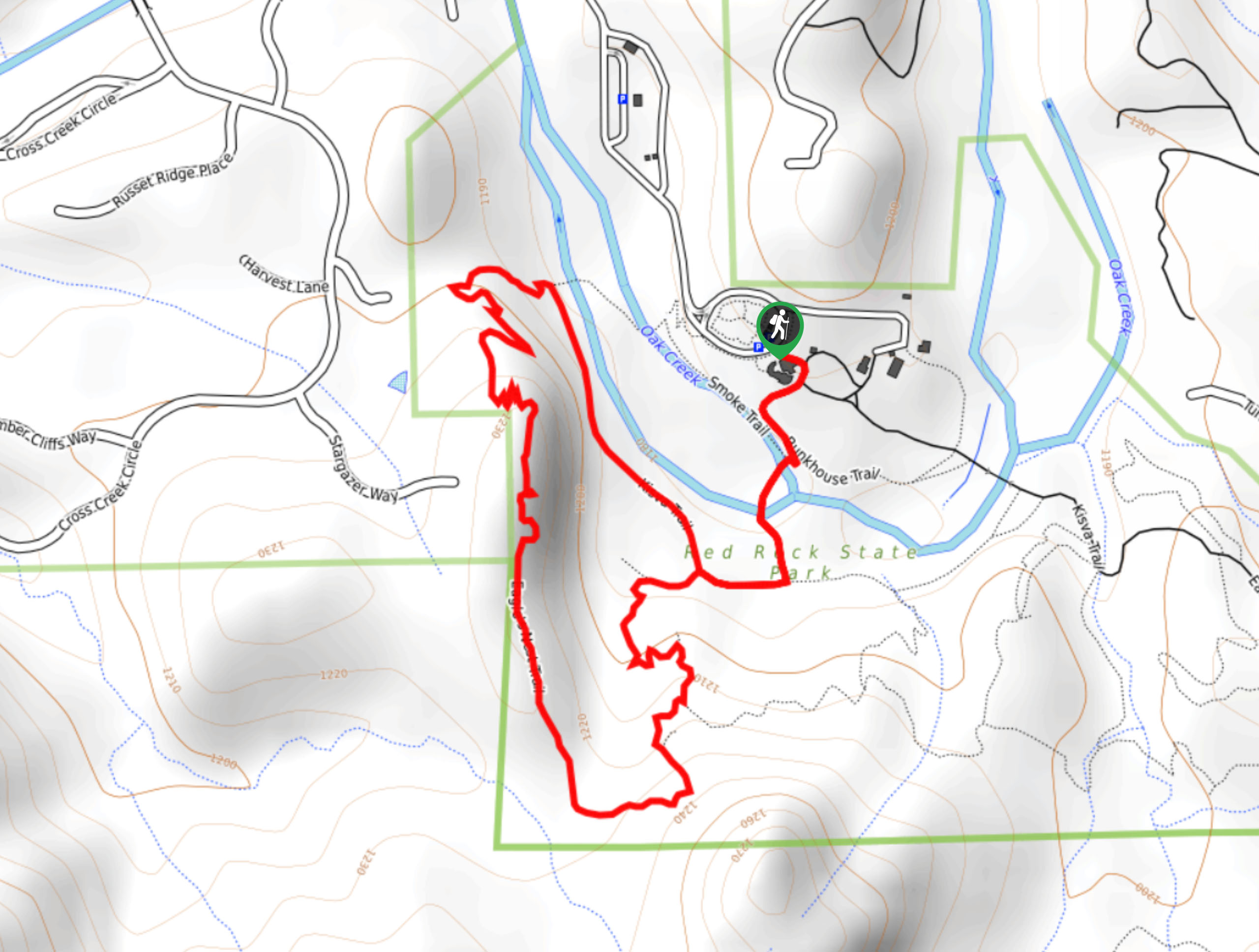
Eagles Nest Trail
View Photos
Eagles Nest Trail
Difficulty Rating:
Eagles Nest Trail is a 2.4mi moderately trafficked loop in Red Rock State Park. This trail is easy and scenic, with a great view of Sedona from the Eagles Nest. Since this route is frequented by mule deer, you might get to observe some wildlife en route. There is a modest entrance fee required for this hike that supports Arizona State Parks.
Getting there
The trailhead for the Eagles Nest Trail is in front of the Red Rock State Park Visitor Center.

About
| Backcountry Campground | No |
| When to do | Year-round |
| Pets allowed | No |
| Family friendly | Yes |
| Route Signage | Average |
| Crowd Levels | Moderate |
| Route Type | Loop |
Eagles Nest Trail
Elevation Graph
Weather
Eagles Nest Trail Description
The Eagles Nest Trail is a pleasant easy hike in Red Rock State Park south of Sedona. This hike offers a great view of the city and is a favorite with local deer, so you might be treated to a bit of wildlife watching. While this is a good route for the whole family, dogs are not permitted.
From the visitor center (which is worth a stop before or after your hike), take Bunkhouse Trail across Oak Creek. Turn right on Kisva Trail and then head left up the hill where the loop splits. Climb up the hill, staying right where a spur trail connects.
Atop the ridge, you can walk ahead with a great view of the surrounding landscape. Stroll to where the trail begins to twist and turn its way downhill, then turn right to walk underneath the ridge. If you’re short on time, stay straight to cross the creek and head back to the visitor center. If not, complete the loop and follow the same route back to the trailhead.
Similar hikes to the Eagles Nest Trail hike

Margs Draw Trail
Margs Draw Trail is a bit of a hidden gem. This trail doesn’t get as much traffic as other nearby…

Baby Bell, Llama, and Bail Loop
The Baby Bell, Llama, and Bail Loop is a 3.6mi hike in Sedona near Bell Rock and Courthouse…

Herkenham Trail
Herkenham Trail is a 2.0mi out and back trail in the Coconino National Forest near Sedona. This route…
Comments