
Fox Creek Trail
View Photos
Fox Creek Trail
Difficulty Rating:
Those seeking a wonderful day hike near Sun Valley, Idaho, will likely enjoy the Fox Creek Trail. This beautiful adventure explores blossoming meadows, meandering creeks, and lush woodlands while offering stunning views of the Boulder Mountains. Shared with bikers, hikers, and equestrians, this route boasts the opportunity to indulge in all sorts of recreational interests.
Getting there
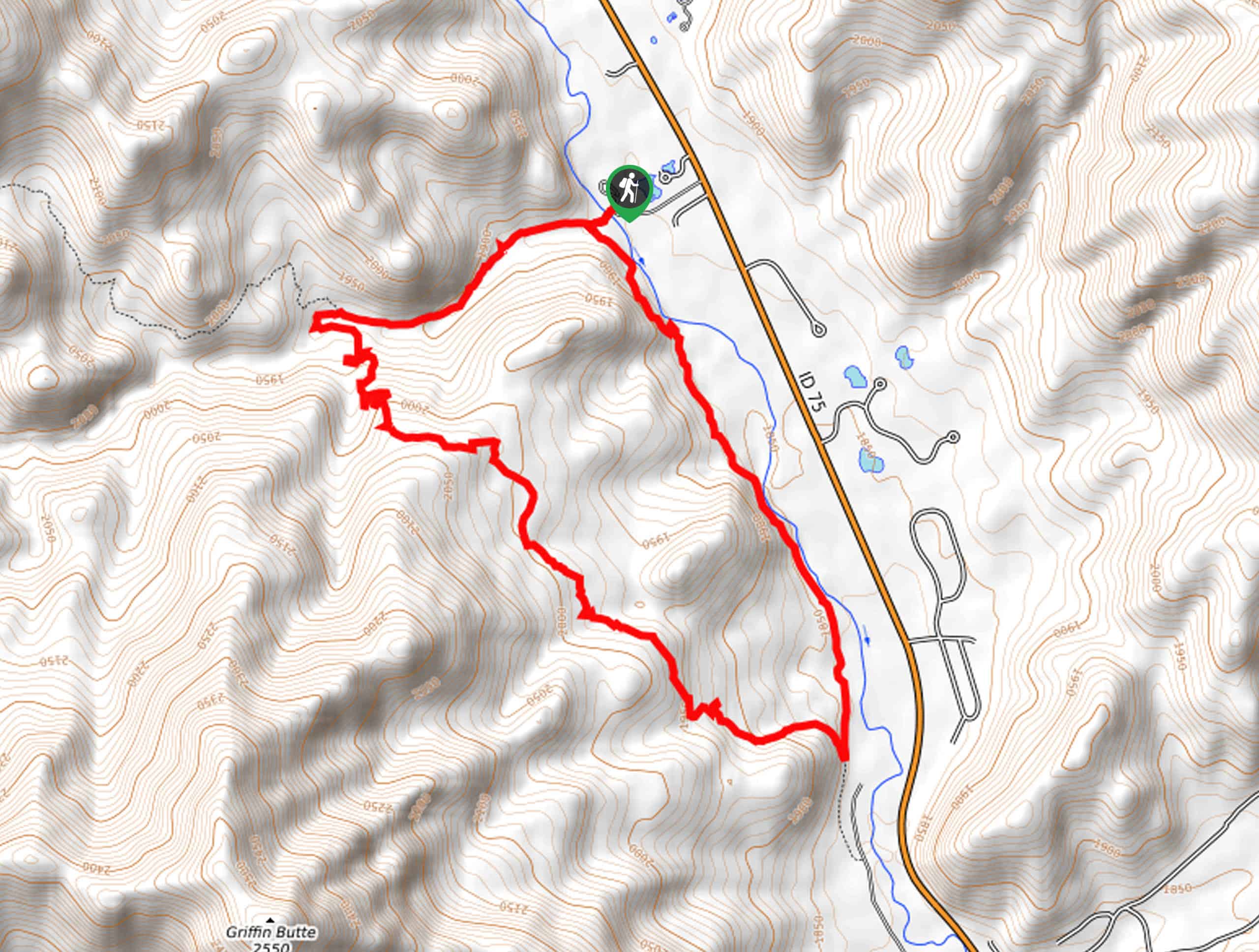
The Fox Creek Hike departs from the Fox Creek Trailhead off Forest Road 020.

About
| Backcountry Campground | No |
| When to do | Year-round |
| Pets allowed | Yes - On Leash |
| Family friendly | Yes |
| Route Signage | Average |
| Crowd Levels | Moderate |
| Route Type | Circuit |
Fox Creek Trail
Elevation Graph
Weather
Fox Creek Hike Description
Escape into the wilderness along the Fox Creek Trail in the Sawtooth National Forest. This hidden gem near Sun Valley and Ketchum is a favorite amongst Idahoans, so we thought we would share this beautiful hike with some of our favorite adventurers. Beckoning the exploration of bikers and equestrians in addition to foot traffic, this route is often uneven and rutted, so hikers are encouraged to be mindful of their footing. Additionally, after rainfall and in the spring, the terrain becomes unstable with mud, so avoid the area during this time, or simply turn around when you encounter these precarious areas. Note much of the path is exposed, so wear SPF and bring plenty of water! Lastly, it is important to be mindful of wildlife as you explore, including bears, deer, and waterfowl near the riverside.
The Fox Creek Trail offers more than just the opportunity to get out into the fresh air—it boasts the opportunity to connect with nature as it exhibits a diversity of flora and fauna. While this trail is open and accessible year-round, summer is our favorite time to wander this route when the meadows are abundant with an array of vibrant wildflowers, and the vegetation is lush! If you cannot get out in the warmer months, autumn adventures are equally as enchanting as the foliage is changing, and the trail wanders through corridors of lovely golden aspens. The truth is, no matter the season, the Fox Creek Trail provides a pleasant experience, and the stroll along Big Wood River is quite peaceful.
Your journey along the Fox Creek Trail begins from the trailhead off Forest Road 020. Setting out from here, the Fox Creek Loop travels southwest, over the footbridge above Big Wood River to a junction. Keep right along the Fox Creek Loop, meandering alongside the lazy moving creek. Alternating between the shade of the mixed woodlands and the unshaded meadows, the westbound trail will gently climb up to an intersection with the Chocolate Gulch Trail. Keep left, and the Fox Loop Trail will reroute you southwardly, demanding a more intense ascent via a set of switchbacks.
After some climbing, you will reach the hike’s highest point, which overlooks the Boulder Mountains and the valley below. Take a rest, rehydrate and revel in the expansive views of the mountainscape, then continue your trek, now descending through pine woodlands interspersed with aspens and scenic blossoming meadows. Now traveling southeast, you will be granted distant views of Ketchum. Eventually, the path will guide you to another trail fork. Veer left here, and you will be rerouted north alongside the Big Wood River.
The final leg of your adventure travels along the forested riverbanks, providing a retreat from the beating sun. As you wander the gently undulating route, you will be relaxed by the sounds and the scene of the running river. Keep an eye and ear out for bikers passing by, and you will ultimately cross a bridge over Fox Creek before confronting the intersection at the Big Wood River Bridge. Here, turn right and hop across the bridge and back to the trailhead and parking lot—marking the end of your exciting excursion.
Frequently Asked Questions
How long is the Fox Creek Trail?
The Fox Creek Trail is a 5.3mi circuit hike near Sun Valley, Idaho.
Are hikers permitted on the Fox Creek Trail?
The Fox Creek Trail is open to hikers, equestrians, and mountain bikers alike, but bikers must travel in a counterclockwise direction.
Insider Hints
Expect muddy conditions, notably in the spring and following rainfall
Be mindful of mountain bikers passing-by
Pack plenty of water and wear sun protection
Please keep your pets leashed
Bikers must travel counterclockwise
Bring insect repellent, the bugs can be relentless
When exploring in the winter months be sure to strap on a pair of snowshoes
Similar hikes to the Fox Creek Trail hike
Hyndman Creek Trail
The Hyndman Creek Trail is an enchanting adventure up the slopes of the highest peak in the Hyndman Mountains. Explore…
Heart Lake Trail
The Heart Lake Hike explores an area of tree burn that is abundant with lush regrowth in the Sawtooth National…

Warm Springs Loop Hike
Remarkable mountain views await you on the Warm Springs Loop Hike in the Sawtooth National Forest. What is a popular…
Comments