
Mount Hankin Bluffs Loop Trail
View Photos
Mount Hankin Bluffs Loop Trail
Difficulty Rating:
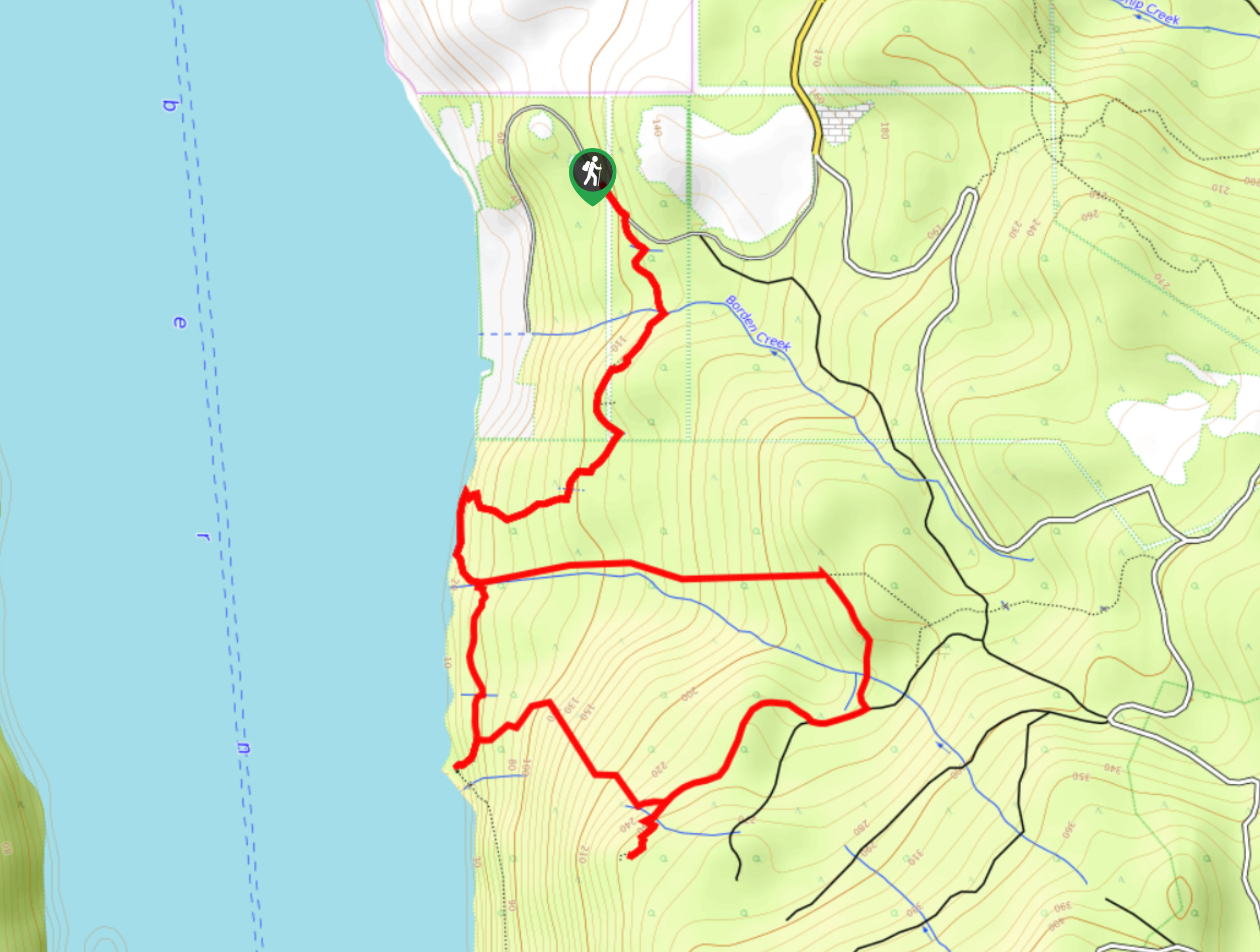
The Mount Hankin Bluffs Loop is a moderate length lollipop hiking route just south of Port Alberni that will expose you to some beautiful views overlooking the waters of the Port Alberni Inlet. While out on the trail, you will climb uphill through lovely stretches of forest terrain until you arrive at the bluffs to experience serene views of the ships and floating timber within the inlet. Although the trail is fairly well laid out, logging operations in the area can make navigation confusing at times. Be sure to keep an eye out for trail markers.
Getting there
To get to the trailhead for the Mount Hankin Bluffs Loop Trail from Port Alberni, make your way south for 0.8mi along 3rd Avenue and turn left onto Ship Creek Road. Follow this for 0.7mi and turn right onto Seizai Road. After 1.0mi, you will find the parking area on the left.

About
| When to do | March-November |
| Backcountry Campsites | No |
| Pets allowed | Yes - On Leash |
| Family friendly | Older Children only |
| Route Signage | Poor |
| Crowd Levels | Low |
| Route Type | Lollipop |
Mount Hankin Bluffs Loop Trail
Elevation Graph
Weather
Mount Hankin Bluffs Trail Description
Hiking the Mount Hankin Bluffs Loop is a fantastic experience if you enjoy hikes through the forest and breathtaking vistas overlooking picturesque bodies of water. Setting out from the roadside parking area, head south through the dense cover of the forest before traversing a section of recently forested terrain. Here, you will descend the hillside towards the water and experience some beautiful views, walking along the edge of the water until you arrive at South Camp Beach. At this point, you will climb up the steep hillside to eventually reach the viewpoint atop the bluffs. While taking in the stunning views overlooking the Alberni Inlet and surrounding forests, maybe stop for a quick picnic lunch with spectacular views. After spending some time on the bluffs, follow the trail to the northeast until you cross over Follinsbee Creek, following it to the west to descend the hillside on the return leg of the journey back to the parking area.
Similar hikes to the Mount Hankin Bluffs Loop Trail hike
Fir Baby Trail
The Fir Baby Trail is a great hiking route on the eastern edge of Port Alberni, BC, that will lead…
Roger’s Creek Nature Trail
Hiking the Roger’s Creek Nature Trail is an amazing family-friendly adventure just outside of Port Alberni that will expose you…
China Creek Falls Hike
The China Creek Falls Hike is a short 1.7mi out-and-back route that will take you through a charming…
Comments