
Scarlett Canyon Hike
View Photos
Scarlett Canyon Hike
Difficulty Rating:
Scarlett Canyon is a route in Phoenix that shows off a small canyon in a suburban park. This trail is used by hikers, mountain bikers, and horseback riders, but it doesn’t usually get too busy. Some of the difficulty rating comes from the footing–be ready to navigate some big boulders that might be tough for dogs and small kids to get over on their own. Sturdy boots are recommended for this hike.
Getting there
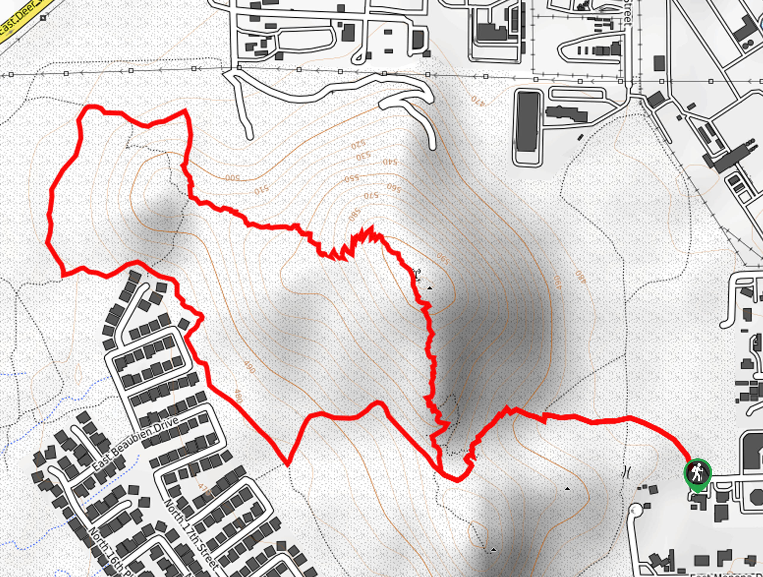
The trailhead for the Scarlett Canyon hike is at the end of E Rose Garden Lane.

About
| Backcountry Campground | No |
| When to do | October-May |
| Pets allowed | Yes - On Leash |
| Family friendly | Yes |
| Route Signage | Poor |
| Crowd Levels | Low |
| Route Type | Loop |
Scarlett Canyon Hike
Elevation Graph
Weather
Scarlett Canyon Hike Description
The Scarlett Canyon hike is a neighborhood trail that follows a lesser-known, officially unnamed route through a canyon in the saddle of two low mountains. This route is used by mixed traffic and doesn’t get very busy. Note that it’s not well-marked, so we definitely recommend bringing a GPS route to refer to.
This route has some very rocky sections and there is terrain that could be challenging for small kids and dogs. We recommend doing as the bikes and horses do and sticking to the flat, easy trails instead of heading up the mountain if you want the easiest trail possible.
From the trailhead, head towards the canyon. Climb up to the base of the loop and stay right. After the highpoint of the trail, descend off the hill and bear left to pass the houses and Bluebell Mine. Hike up over the saddle again and then retrace your steps to the trailhead.
Similar hikes to the Scarlett Canyon Hike hike

Palisade to Basalt Loop
The Palisade to Basalt Loop is a short, easy trail in the Deem Hills Recreation Area. This hike is 1.4mi

Two Bit and Rattle Saddle Loop
The Two Bit and Rattle Saddle Trail is a moderately challenging hike in the Phoenix’s Mountain Preserve near Piestewa Peak.…

Ma-Ha-Tauk and Crosscut Loop
The Ma-Ha-Tauk and Crosscut Loop is a moderate hike in Phoenix’s South Mountain Preserve. With pleasant views and not much…
Comments