
Dixie Mountain Two Summit Loop
View Photos
Dixie Mountain Two Summit Loop
Difficulty Rating:
The Dixie Mountain Two Summit Loop is a mi moderate hike in Phoenix’s Sonoran Desert Preserve. This hike is suitable for strong beginners. It leads you through rolling hills flanked by saguaro, cholla, and nesting owls. You’ll summit two peaks, one of which is Dixie Mountain. Take in views of the mountains of the preserve and the city surrounding you with an ever-changing vantage point. Expect heavy traffic on this hike.
Getting there
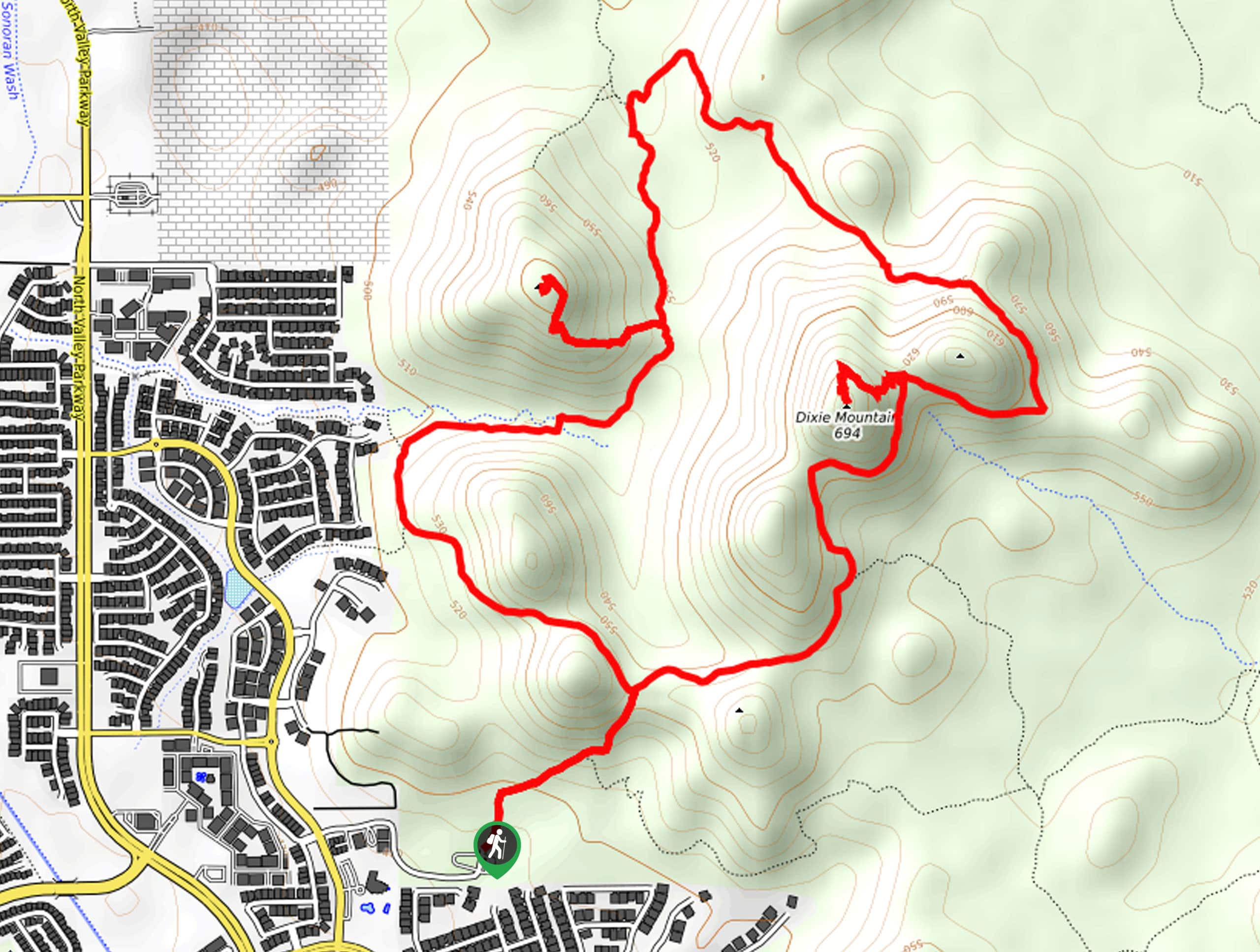
The trailhead for the Dixie Mountain Two Summit Loop is at the end of W Desert Vista Trail.

About
| Backcountry Campground | No |
| When to do | October-May |
| Pets allowed | Yes - On Leash |
| Family friendly | Older Children only |
| Route Signage | Average |
| Crowd Levels | High |
| Route Type | Loop |
Dixie Mountain Two Summit Loop
Elevation Graph
Weather
Dixie Mountain Two Summit Loop Description
The Dixie Mountain Two Summit Loop is a hike in Phoenix’s Sonoran Desert Preserve that shows off the beauty of the Sonoran Desert. This hike is lined by saguaro (sometimes with nesting owls in their arms), cholla, and rolling mountain peaks. You’ll reach the top of one of the smaller hills after summiting Dixie Mountain.
This hike is moderate and we’d consider it suitable for strong beginners and better. As with all hikes in the Phoenix area, make sure you bring lots of water with you and consider wearing sun protection. Time your hike outside of the heat of the day.
From the trailhead, our route travels counterclockwise. You’ll hike on Hawk’s Nest Trail, staying left at the first fork. The second fork is where the loop splits. Go right onto Dixie Mountain Loop. stay left at the next fork and then take a left to climb uphill on the trail to the summit. Take a moment to appreciate this vantage point before making your way down the mountain.
Stay left at the fork to continue on the Dixie Mountain Loop as it travels northwest. The route will turn south, and you’ll take a right to ascend and then descend a smaller peak. Continue along the Dixie Mountain Loop as it leads you back to the trailhead.
Similar hikes to the Dixie Mountain Two Summit Loop hike

Palisade to Basalt Loop
The Palisade to Basalt Loop is a short, easy trail in the Deem Hills Recreation Area. This hike is 1.4mi

Two Bit and Rattle Saddle Loop
The Two Bit and Rattle Saddle Trail is a moderately challenging hike in the Phoenix’s Mountain Preserve near Piestewa Peak.…

Ma-Ha-Tauk and Crosscut Loop
The Ma-Ha-Tauk and Crosscut Loop is a moderate hike in Phoenix’s South Mountain Preserve. With pleasant views and not much…
Comments