Tegg’s Nose Walk
View Photos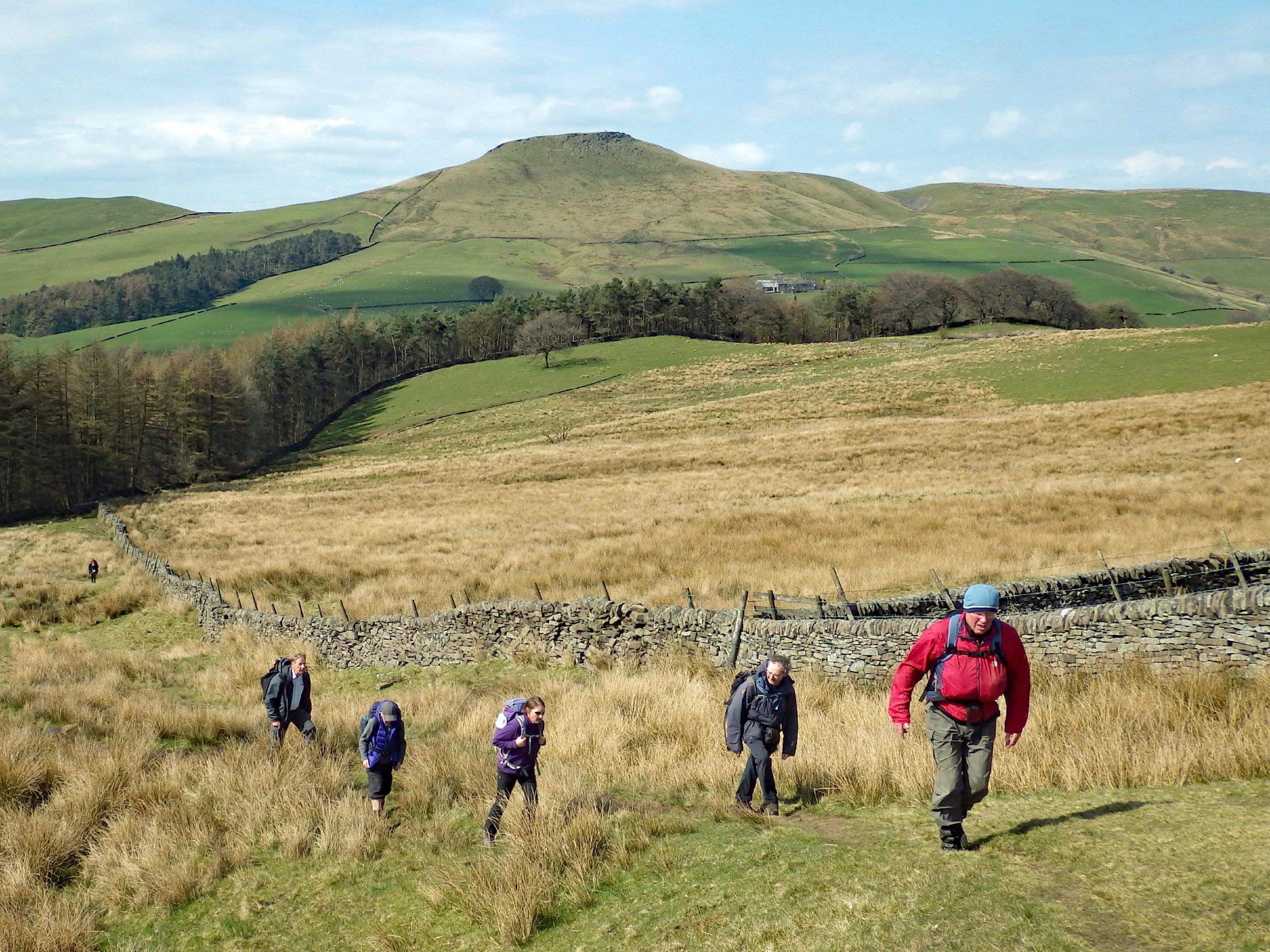
Tegg’s Nose Walk
Difficulty Rating:
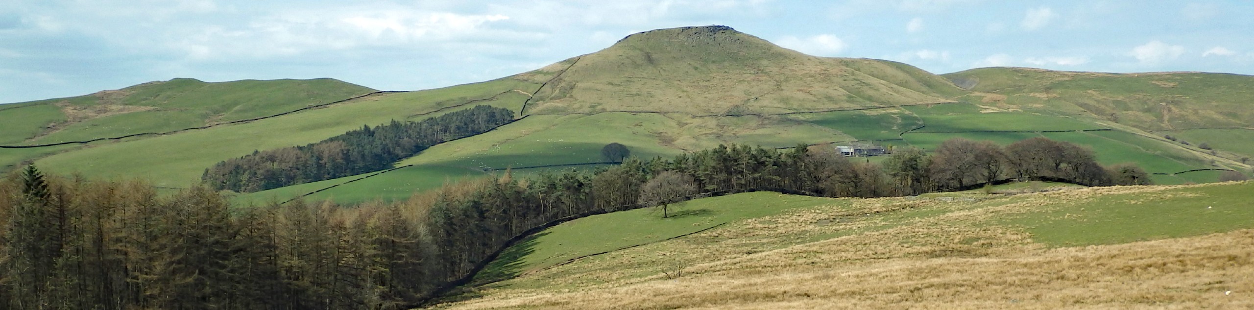
If you are searching for a fairly short walk with some nice variation in terrain and spectacular views overlooking scenic woodlands and rolling green hills, then look no further. The Tegg’s Nose Walk is a 2.6mi circuit that will lead you through serene stretches of forest along the foot of the hill and past several scenic reservoirs before climbing uphill for a commanding view over the farms and villages of the surrounding area. There is a bit of elevation gain along the route, but it is more than manageable for walkers of most skill levels.
Getting there
To get to the trailhead for the Tegg’s Nose Walk from Macclesfield, head to the southwest for 1.2mi along Buxton Old Road, where it will turn slightly left and transition into Buxton Road/A537. You will find the car park on the right in 0.8mi.

About
| When to do | March-October |
| Backcountry Campsites | No |
| Pets allowed | Yes - On Leash |
| Family friendly | Yes |
| Route Signage | Average |
| Crowd Levels | Moderate |
| Route Type | Circuit |
Tegg’s Nose Walk
Elevation Graph
Weather
Tegg’s Nose Walk Description
The Tegg’s Nose Walk is a popular route for taking a quick stroll when you haven’t much time, and as such, it can see a large amount of foot traffic and a limited amount of parking during peak hours. Make sure to arrive early enough to secure a spot in the car park if you are planning to attempt this walk on the weekend. Additionally, there are a few steep bits, so wear proper footwear when setting out for this walk.
While it may only be a short walking route, this trail offers spectacular views over the beautiful Cheshire landscape that you just won’t find anywhere else. The route descends from Tegg’s Nose Country Park and offers some views overlooking the Macclesfield Forest before skirting along the edge of the hill and the Tegg’s Nose Reservoir to climb atop the ridge. From here, you will have a commanding view of the vibrant green terrain that serves as a patchwork of small villages and farms nestled within the hilly landscape. For only a short jaunt of uphill walking, the views along the Tegg’s Nose Walk are more than enough of a reward for your effort, with the added bonus of being able to spot a wide variety of wild bird species along the route!
Setting out from the car park, follow the path to the southeast that will take you downhill through the forest along Saddler’s Way. After 0.1mi, pass through the gate and continue on for 0.2mi until you meet up with the road. Follow it to the right and press on for another 0.1mi, where you will find a track along a stone wall branching off to your right.
Take this path, and you will quickly come to a small gate, at which point you should keep left and continue heading south for 0.2mi until you come to a second gate. Pass through and make your way along the steps, turn left at the junction, and continue along the steps until you come to a stream. Make your way across the water and keep right along the path to walk parallel to the stream and eventually arrive at the edge of the Tegg’s Nose Reservoir.
Here, you will have a fantastic opportunity to view over 15 different bird species that inhabit the area in and around the water’s edge. Pause for a moment to survey the landscape, scouring the surface of the two reservoirs and the surrounding brush with the hopes of spotting Canadian Geese, Cormorant, Mallard, Tufted Duck, and Grey Heron, just to name a few.
After experiencing the beautiful wildlife, continue along the trail as it passes between the two calm bodies of water, with the Tegg’s Nose reservoir on the right and the Bottoms Reservoir on your left. Upon arriving at the gate, pass through and keep to the right to walk along the dam wall and into the forest. Take the path to the left of the car park and pass through a series of kissing gates before following the trail on an uphill climb through the forest that leads up to the top of Tegg’s Nose.
After roughly 0.2mi, the path will break out of the tree cover and bend to the right on a more direct route to the summit that will take you through some lighter brush covered with heather, holly, gorse, and hawthorn. This landscape offers great birding opportunities as well, so carefully navigate through the brush for the chance to see nearly 20 different species like Robin, Goldfinch, Blackbird, Partridge, and Nuthatch take flight before you.
Enjoy the amazing views stretching out across the valley as you continue to gain elevation over the reservoirs and Macclesfield Forest below. After exiting the tree cover, keep left for 0.3mi, where you will head to the right and ascend a series of steps. After traversing the steps and arriving near the summit of Tegg’s Nose, you will likely be able to spot some Buzzards, Ravens, and Kestrels that prefer to spend their time at this higher elevation From the top of the stairs, make your way through the gate and head left, passing straight through any junctions for 0.3mi.
When you have reached the T-intersection, take the path to the right and follow it straight, passing through a gate to set out on the final stretch of the walk. After 0.2mi, you will pass through a kissing gate and make your way to the car park where you began your walk. From here, you can choose to either continue exploring the area around the summit of Tegg’s Nose to see some of the quarry operations that used to take place here or pick up a quick snack at the Tegg’s Nose Tea Room before heading home, having completed the Tegg’s Nose Walk.
Frequently Asked Questions
How much does it cost to park at Tegg’s Nose Country Park?
Pay and display parking is available at Tegg’s Nose Country Park and runs £2 for 1-3h, which should be plenty for this walk.
Why is it called Tegg’s Nose?
Although there is no definitive answer, possible suggestions at the name Tegg’s Nose stem from Norse settlers that made their way into the area. Old maps of the area refer to it as Tegge’s Naze, where Tegge could be the name of one such settler and Naze or Nose is reflective of a high point in the landscape.
Are there any birding opportunities along the Tegg’s Nose Walk?
Walking along this trail offers great chances to spot a number of different bird species that inhabit the area depending on the time of year. The landscape around the reservoirs at the foot of the hill is home to a large number of bird species, including Canadian Geese, Cormorant, Mallard, Tufted Duck, Teal, Coot, Little Ringed Plover, Mandarin Duck, Pochard, Moorhen, Great Crested Grebe, Grey Wagtail, Black Headed Gull, Grey Heron, Goosander, Goldeneye, and the Common and Green Sandpiper.
Further uphill, you will make your way through some light brush that offers the chance to see several species of Tit, Blackbirds, Robin, Goldfinch, Goldcrest, Nuthatch, Chaffinch, Partridge, Magpie, Crow, Chiff Chaff, Willow Warbler, Black Cap, Linnet, Song Thrush, Kestrel, Jackdaw, and rook.
At the exposed hilltop, you can spot Buzzards, Kestrels, and Ravens that prefer the rocky and rugged terrain and higher elevation that allows them to better spot their prey on the ground below.
Other amazing walks in Peak District National Park
Check out our guides to Kinder Scout, Mam Tor, Stanage Edge, Dovedale, and Padley Gorge. Or see all of our Peak District walks on 10Adventures.
Insider Hints
Parking is £2 for 1-3h or £3 for up to 10h, although the former should be enough time for this walk.
Pop into the Tegg’s Nose Tea Room to pick up some snacks for before or after your walk.
Try exploring the area around the summit of the hill, as it has some old quarry equipment that gives insight into the mining operations that once took place here.
Similar hikes to the Tegg’s Nose Walk hike

Valehouse Reservoir Circular
The Valehouse Reservoir Circular is a 3.1mi lollipop trail near Glossop that travels around the edge of the…

Three Edges Walk
The Three Edges Walk is a challenging circuit in Derbyshire that will take you along three escarpments that offer some…

Edale Rocky Ridges Walk
The Edale Rocky Ridges Walk is just that - an adventurous walk along a rugged ridgeline. While out on the…
Comments