Thorpe Cloud Walk
View Photos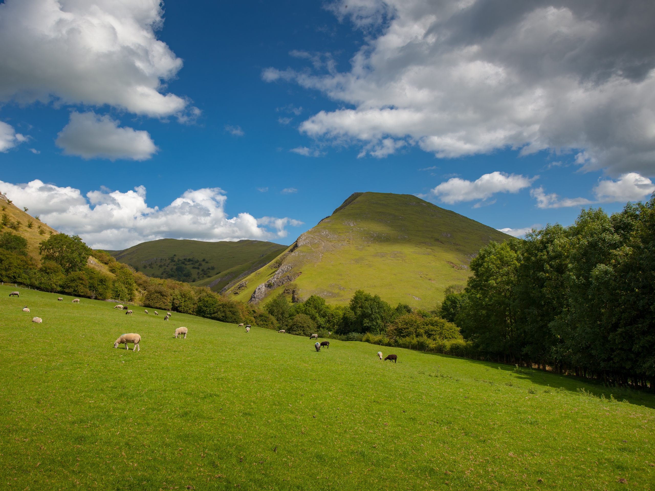
Thorpe Cloud Walk
Difficulty Rating:
Walking up Thorpe Cloud is a fantastic outdoor experience that will take you along a 1.8mi circuit through the rolling green hills of the borderlands between Staffordshire and Derbyshire. Along the walk, you will summit the hill for some breathtaking views across the dale and pass by the stepping stones across the River Dove. Made up of pleasant and easy-to-navigate terrain, this walk is perfectly suitable for all ages and skill levels.
Getting there
To reach the Thorpe Cloud parking area from Ashbourne, drive northwest on Buxton Road/A515 for 0.9mi and turn left onto Spend Lane. After 1.9mi, turn left onto Wintercroft Lane and follow it for 0.5mi. Continue straight along Thorpe Road for another 0.3mi and turn left to park your vehicle.

About
| When to do | Year-Round |
| Backcountry Campsites | No |
| Pets allowed | Yes - On Leash |
| Family friendly | Yes |
| Route Signage | Average |
| Crowd Levels | Moderate |
| Route Type | Circuit |
Thorpe Cloud Walk
Elevation Graph
Weather
Thorpe Cloud Trail Description
The Thorpe Cloud Walk is a fun route near the southern tip of the Peak District that is popular with all levels of walkers and dog walkers due to the pleasant terrain and scenic views. For this reason, you might experience quite a bit of foot traffic while out on your walk, so make sure to arrive early enough to secure parking and enjoy the trail without throngs of other people. Additionally, if the parking area is full, try heading to the nearby Dovedale Car Park to tackle this walk from a different starting point.
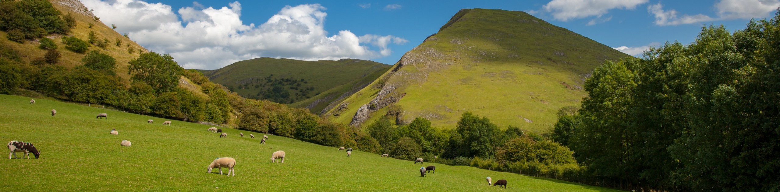
When you think of the pristine English countryside, the images that you might conjure up will be similar to the scenery that can be found along the Thorpe Cloud Walk. Rolling green hills, winding rivers, and quaint villages will stretch out before you from the scenic viewpoint at the summit of this limestone hill. With such amazing views and an easy-to-traverse path, there is no reason to hold off planning your next walk around Thorpe Cloud.
Setting out from your parked vehicle, make your way back to Thorpe Road and cross over to the other side, following it to the right for 225ft to pick up the trail. From here, follow the path north for 408ft, where you will come to a gate. Pass through the gate and head to the right along the trail as it runs parallel to a fence for 0.3mi and passes by a farm on the right. Once you have reached the intersection in the trail, take the path to the left and pass straight through the next junction to climb up to the summit of Thorpe Cloud.
Once you have reached the top of the 942ft peak, take some time to explore the hilltop and enjoy the breathtaking views that sweep across the vibrant green countryside. To the north, you will be able to look out across the dale and the meandering waters of the River Dove, and to the south, your sightline will stretch across the Midland Plain. After taking in the views, continue along the trail that descends the backside of the hill and leads down to the edge of the river.
Towards the edge of the River Dove, there is a stretch of rocky terrain, so watch your step as you walk the last few feet towards the junction in the trail. Once you reach the junction, you will have the option of taking a short detour to the left that will bring you to the edge of the river, where you can explore the stepping stones that were created during the Victorian Era to allow tourists to cross the river. Don’t cross over the river. Instead, head right at the aforementioned junction and follow the trail as it turns to the southeast.
Here, walkers will make their way around the foot of Thorpe Cloud for 0.4mi until they arrive at a junction in the trail. Head straight through and continue on for 0.3mi to once again pass by the farm from before (now on your left) and reach the first gate along the trail. Turn left and head through the gate to make your way back to Thorpe Road and your parked car. From here, you can either head home or pop into The Old Dog pub in Thorpe Village to celebrate your completion of the Thorpe Cloud Walk.
Trail Highlights
Thorpe Cloud
Located along the Derbyshire/Staffordshire border between the villages of Thorpe and Ilam, the Thorpe Cloud is an isolated limestone hill that provides a commanding view of the surrounding countryside, with a great sightline stretching north to south from the dale toward the Midland Plain.
Dovedale Stepping Stones
Spanning the River Dove in the shadow of Thorpe Cloud, these stepping stones were created during the Victorian Era as a means for the increasing number of tourists in the region to cross over the river. Try not to fall in as you hastily skip across the rushing water of the river!
Other amazing walks in Peak District National Park
Check out our guides to Kinder Scout, Mam Tor, Stanage Edge, Dovedale, and Padley Gorge. Or see all of our Peak District walks on 10Adventures.
Insider Hints
This easy trail is a popular spot for dog walking, so don’t forget your canine friends when you set out for your walk. Just remember to keep them on-leash, as there are grazing sheep in the area.
For movie trivia fans, Thorpe Cloud was used as a filming location in the 2010 Russell Crowe film Robin Hood.
Head out to The Old Dog in the nearby village of Thorpe for some post-walk refreshments.
Similar hikes to the Thorpe Cloud Walk hike

Valehouse Reservoir Circular
The Valehouse Reservoir Circular is a 3.1mi lollipop trail near Glossop that travels around the edge of the…

Edale Rocky Ridges Walk
The Edale Rocky Ridges Walk is just that - an adventurous walk along a rugged ridgeline. While out on the…
Ladybower Reservoir & Derwent Edge Walk
The Ladybower Reservoir & Derwent Edge Walk is a fantastic route that offers gorgeous views across the Peak District Landscape.…
Comments