Monsal Dale Walk
View Photos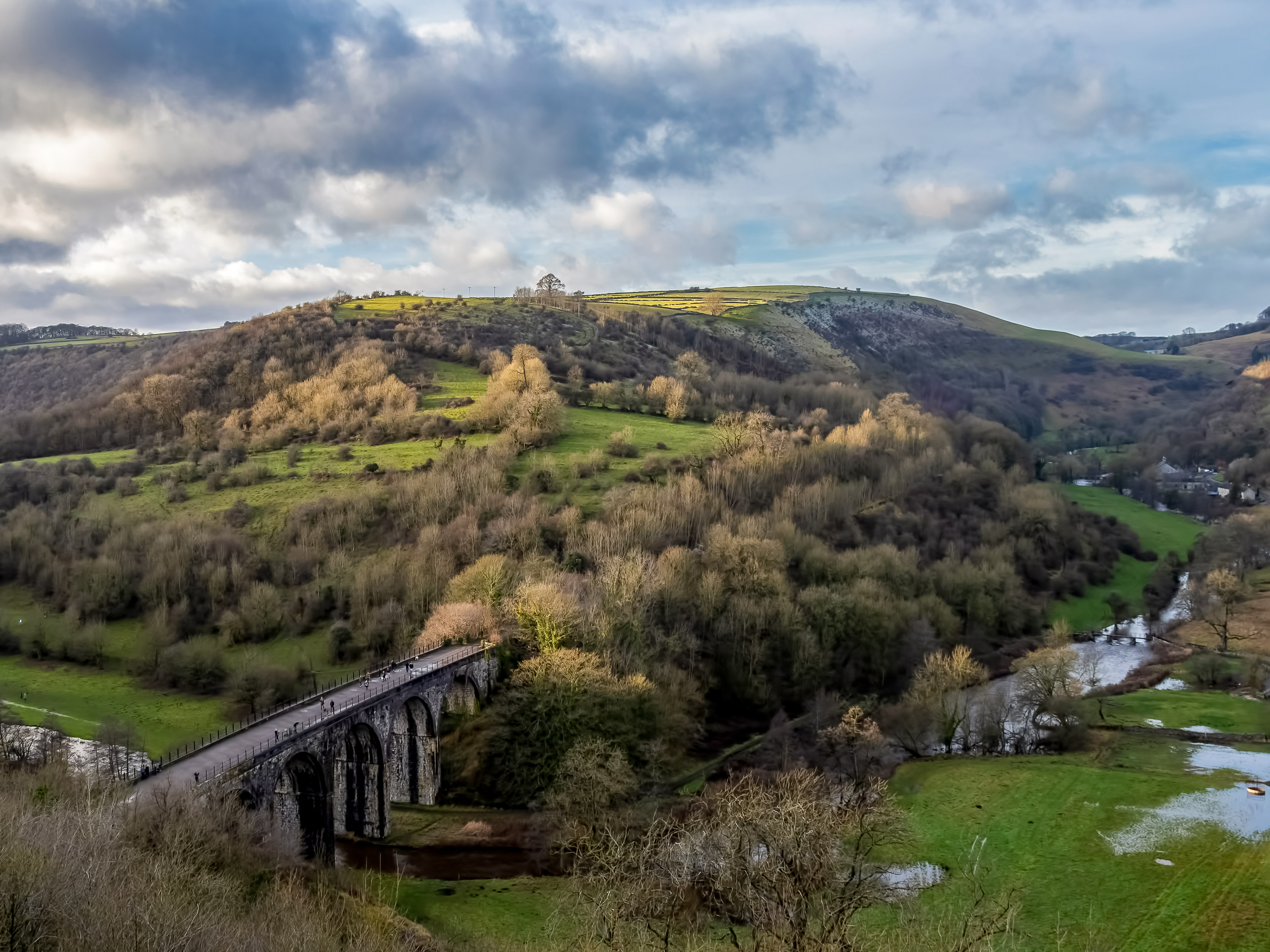
Monsal Dale Walk
Difficulty Rating:
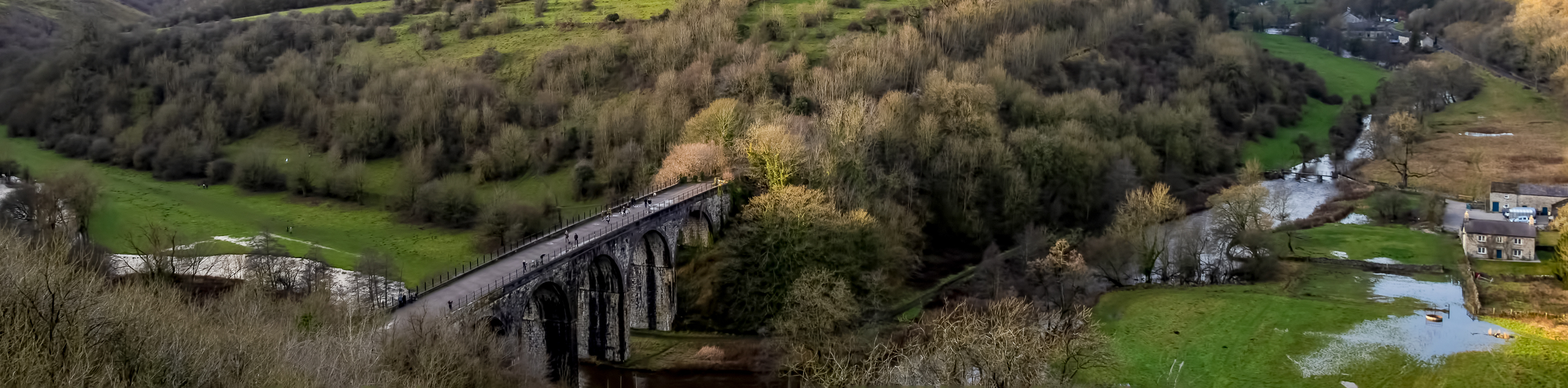
The Monsal Dale Walk is a fantastic walking route that will allow you to experience a number of different terrain types throughout the beautiful Derbyshire countryside. The trail sets out from Monsal Head and traverses some scenic farmland to the east before looping back to cross over the River Wye along the Monsal Dale Viaduct. After making your way over the impressive structure, you will stroll through the forests along the banks of the meandering River Wye before arriving back at the trailhead. This is a wonderful walk without much difficulty, that features some truly beautiful scenery.
Getting there
To reach the Monsal Head car park from Buxton, head southeast on the A6 for 9.1mi and turn left onto Buxton Road. After 0.3mi, turn left onto Vicarage Lane and follow it for another 0.3mi. Merge onto Ashford Lane/B6465 and follow it for 1mi before turning left onto Ashford Lane. In 95ft, you will find the car park on the right.

About
| When to do | March-November |
| Backcountry Campsites | Park House Camping |
| Pets allowed | Yes - On Leash |
| Family friendly | Yes |
| Route Signage | Average |
| Crowd Levels | Moderate |
| Route Type | Circuit |
Monsal Dale Walk
Elevation Graph
Weather
Monsal Dale Walk Description
The Monsal Dale Walk is a fun outdoor adventure that the entire family can enjoy; however, there are a few things to consider before setting out on your walk. Make sure to arrive early, as parking in Monsal Head can be limited and there are a number of visitors that come to the area to view the viaduct. Additionally, make sure to wear decent walking footwear, as there are some steep sections of trail along the forested parts of the walk.
As mentioned, this walking route is perfect for a fun day of family exploration in the picturesque Derbyshire countryside. From lush, open tracts of farmland to dense atmospheric forests, this trail will allow you to experience the natural beauty of the surrounding landscape, as well as the charming villages that can be found throughout the area.
Setting out from the trailhead in Monsal Head, make your way east along Butts Road for 0.4mi to pass by the beautiful stone Congregational Chapel on your left and enter into the quaint village of Little Longstone. After passing by the Packhorse Inn on your left and The Hollow Dining Rooms on your right, you will spot a stile on the right side of the road. Cross over this and pick up the trail on the other side to begin making your way through a scenic stretch of farmland.
Continue through the picturesque Derbyshire countryside for 0.4mi, passing through one gate and crossing over a stile to come to a junction in the trail. Follow this to the right to continue along the Monsal Trail and head back toward the village. Make your way straight along the tree-lined track for 0.6mi, crossing over Ashford Lane to arrive back at the car park. Continue past it and make your way through the trees to eventually arrive at the Monsal Dale Headstone Viaduct, an old railway crossing that spans the River Wye.
Make your way over the historic arched structure and continue along the trail for 200ft to turn left onto Brushfield Lane. Follow the wide, well-groomed track to the west for 0.9mi, passing through any gates and keeping the downhill slope of the forested river valley on your left side. Here, you will find a trail on your left. Follow this, as it turns to the south and eventually meets up with a gate in front of the Brushfield Hough Farm in 0.2mi. Pass through the gate and make your way along the track between the buildings, heading left to pass through a series of gates to meet up with the lane.
Follow the lane for 0.1mi, as it leads you over a stile and into the thick cover of the forest. Continue along the trail as it descends the steep hill towards the edge of the River Wye. One you have reached the junction at the bottom of the valley, follow it to the left for 0.1mi to meet up with the flowing water of the river. From here, continue along the western bank of the river for 0.7mi, where you will meet up with a fork in the trail. Keep left here and follow the path east on a route that will take you back to the viaduct.
After arriving back at the scenic bridge crossing, make your way back over the River Wye toward the village of Monsal Head to wrap up your journey along the Monsal Dale Walk. Before heading home, make sure to stop by The Stables pub or Hobb’s Cafe for some post-walk drinks and/or food.
Other amazing walks in Peak District National Park
Check out our guides to Kinder Scout, Mam Tor, Stanage Edge, Dovedale, and Padley Gorge. Or see all of our Peak District walks on 10Adventures.
Insider Hints
Arrive early, as parking near the trailhead can be limited.
Wear proper footwear, as parts of this walk are steep and can become slick when wet.
The Stables Pub and Hobb’s Cafe offer two great spots near the trailhead for pre/post-walk refreshments.
Similar hikes to the Monsal Dale Walk hike

Valehouse Reservoir Circular
The Valehouse Reservoir Circular is a 3.1mi lollipop trail near Glossop that travels around the edge of the…

Three Edges Walk
The Three Edges Walk is a challenging circuit in Derbyshire that will take you along three escarpments that offer some…

Edale Rocky Ridges Walk
The Edale Rocky Ridges Walk is just that - an adventurous walk along a rugged ridgeline. While out on the…
Comments