Hollins Cross Walk
View PhotosHollins Cross Walk
Difficulty Rating:
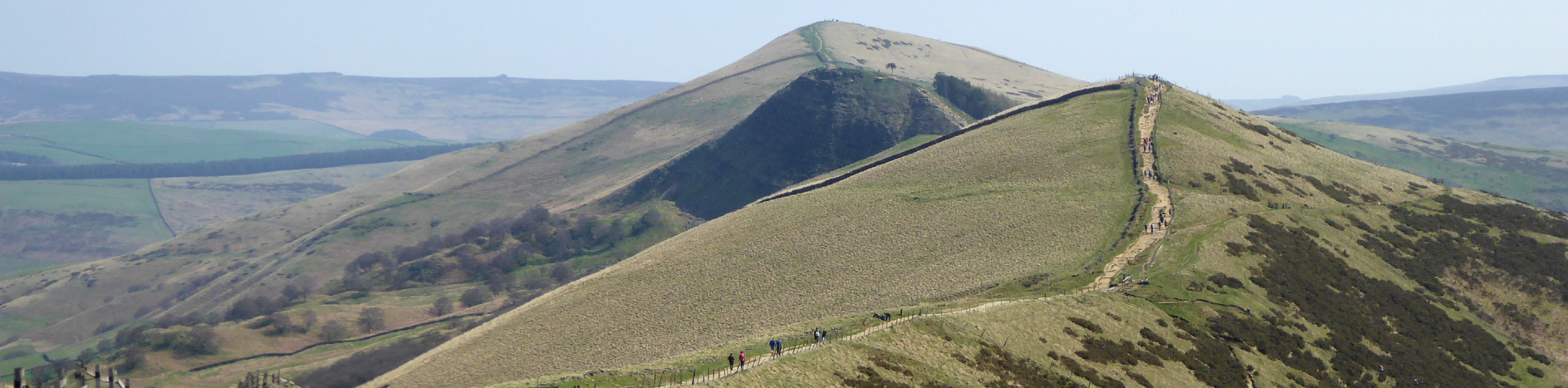
The walk to Hollins Cross is a spectacular journey along The Great Ridge that will allow you to experience some of the best views in Peak District National Park. While out on the trail, you will make your way along a number of prominent hills that include: Mam Tor, Hollins Cross, Back Tor, and Lose Hill, all while enjoying breathtaking views of the surrounding hills and valleys that make this area so beautiful. Due to the ultra-scenic views, this route is very popular, so make sure to arrive early to beat the crowds.
Getting there
To reach the car park for the Hollins Cross Walk from Chapel-en-le-Frith, head northeast along Sheffield Road for 4.2mi and turn left to enter the car park.

About
| When to do | March-November |
| Backcountry Campsites | No |
| Pets allowed | Yes - On Leash |
| Family friendly | Older Children only |
| Route Signage | Average |
| Crowd Levels | High |
| Route Type | Out and back |
Hollins Cross Walk
Elevation Graph
Weather
Hollins Cross Walk Description
Due to the location of Hollins Cross along the Great Ridge, this trail can become extremely busy during peak hours and on weekends. Make sure to arrive early to both secure parking and beat the crowds up onto the ridge. Additionally, this route features some uphill walking as you traverse the rugged ridgeline. Wearing proper walking footwear is recommended to stay comfortable on the trail.
Setting out from the car park, make your way north along the trail as it cuts through the forest and follows closely alongside the road for a short distance. As the path begins to change direction to the northeast, you will begin to climb more steeply uphill on the ascent of Mam Tor. From here, you will have some spectacular panoramic views of the surrounding area that will be present for the duration of the walk along The Great Ridge.
After passing by the Bronze Age hill fort, continue along the ridgeline and take in the views of farms and villages to the southeast, and the rugged terrain of Kinder Scout NNR to the northwest. After reaching the summit of Hollins Cross, you will pass by a monument dedicated to avid walker Tom Hyett that was raised by the Rambler’s Association in 1964. Continue east along the trail to traverse Back Tor and eventually arrive at the final summit on the walk, Lose Hill.
From this point, you will have some more spectacular views that stretch out in every direction, from the undulating ridgeline behind you towards Ladybower Reservoir to the east. After taking in the sights and pausing for a bit of a rest, head back along the same trail to gain the opposite perspective of the scenery on the return journey to the car park.
Other amazing walks in Peak District National Park
Check out our guides to Kinder Scout, Mam Tor, Stanage Edge, Dovedale, and Padley Gorge. Or see all of our Peak District walks on 10Adventures.
Similar hikes to the Hollins Cross Walk hike

Valehouse Reservoir Circular
The Valehouse Reservoir Circular is a 3.1mi lollipop trail near Glossop that travels around the edge of the…

Three Edges Walk
The Three Edges Walk is a challenging circuit in Derbyshire that will take you along three escarpments that offer some…

Edale Rocky Ridges Walk
The Edale Rocky Ridges Walk is just that - an adventurous walk along a rugged ridgeline. While out on the…
Comments